Sign in
 Profile
 Signout
The Central Board of Secondary Education (CBSE) conducted the Class 12 Geography board exam today, February 29, 2024. The exam was conducted between 10.30 am to 1.30 pm.
Now, as the exam is over, we bring you post-exam review, paper analysis and student feedback on the difficulty level of CBSE Class 12 Geography exam 2024. Compare your answers with the CBSE Class 12 Geography Question Paper 2024 Solved PDF available on this page.
👉 CBSE Class 12 Geography Question Paper 2024 with Answer Key Set - 1
👉 CBSE Class 12 Geography Question Paper 2024 with Answer Key Set - 2
👉 CBSE Class 12 Geography Question Paper 2024 with Answer Key Set - 3
CBSE Class 12 Geography Paper Review 2024
CBSE Class 12 Geography Exam 2024 is reviewed to be of moderate difficulty. Students disclosed that the question paper pattern was on the line of the official CBSE sample paper, and nothing was asked out of the prescribed syllabus of geography.
Note: The exam analysis provided here is completely based on the feedback and reviews shared by students and teachers. Exam analysis of the CBSE Class 12 Geography examination should be interpreted as a subjective assessment because individual viewpoints may differ.
Type of Questions Asked in CBSE Class 12 Geography Exam 2024
- The CBSE Class 12 Geography Exam 2024 was for 70 marks and had 30 questions. Students were given 3 hours to complete the paper. All questions were compulsory. However, internal choices were provided in some questions.
- The paper was divided into five sections:
|
Section A |
Multiple-choice-type questions |
1 mark each |
|
Section B |
Source-based questions |
3 marks each |
|
Section C |
Short-answer type questions |
3 marks each |
|
Section D |
Long-answer type questions |
5 marks each |
|
Section E |
Map-based questions |
5 marks each |
CBSE Class 12 Geography Exam Analysis 2024 - Students Reaction
Some of the general reviews by students are as follows:
- As per the students, the geography question paper difficulty level was easy to moderate.
- Students found the geography paper lengthy but manageable.
- Everything was based on the prescribed syllabus and NCERT.
- The MCQ section was easy and scoring.
- Map based questions were comparatively difficult.
- The language of the questions was direct in nature, which made it easy for the students to understand the demands of the questions.
Most of the questions on the paper fell within the easy-to-moderate range. Overall, the CBSE Class 12 geography paper was quite average for almost all the students, and students are expecting good marks in the exam.
CBSE Class 12 Geography Paper Analysis 2024 - Experts' Review
Subject experts reviewed the CBSE Class 12 geography paper and found it easy to moderate on the difficulty level. A detailed expert analysis can be checked below:
- The subject teachers opined that the paper was balanced and had a moderate difficulty level.
- No question was asked outside of the prescribed syllabus.
- The paper pattern followed the format that was provided in the official sample paper of CBSE.
- Students who covered the syllabus in depth will be able to score good marks in the paper.
- Long-answer-type questions were simple but lengthy.
CBSE Class 12 Geography Exam 2024 Analysis – Review by Teacher
Direct questions were easy to answer, while competency-based questions posed an average challenge. Students managed to complete the paper within the allotted time. The paper structure closely resembled the CBSE Sample Paper for the Session 2023-24.
Students exhibited excitement and satisfaction at the exam center, and it was evident on their faces. Conversations with students after the exam revealed overwhelmingly positive feedback. They stated that the paper was well-balanced and aligned with the CBSE curriculum. While case study questions were direct, some multiple-choice questions proved to be slightly tricky.
CBSE Class 12 Geography Exam 2024 Overall Analysis
The recent CBSE Class 12 Geography exam, held today on February 29, received positive feedback from students upon initial review. Here are some key observations:
- Balanced and Simple: Students found the paper to be well-balanced and simple, a positive aspect indicating an even distribution of questions across difficulty levels.
- Syllabus Adherence: It’s reassuring that the paper stayed within the prescribed syllabus, ensuring a fair evaluation of students’ preparedness without introducing unfamiliar topics.
- Emphasis on Analytical Ability: The inclusion of numerical questions to assess analytical skills is commendable, as it evaluates not only theoretical understanding but also practical application of concepts.
- Adequate Time Allocation: Allotting 3 hours for a 70-mark paper appears reasonable, allowing students ample time to tackle questions thoughtfully without feeling rushed.
- Structured Format: The paper’s division into five sections with specified numbers of questions and marks provides a structured framework beneficial for both students and examiners.
- Moderate Difficulty: The overall moderate difficulty level across all sections ensures that the exam appropriately challenges students’ comprehension and application abilities, distinguishing between varying levels of proficiency.
CBSE Class 12 Geography Paper Answer Key 2024 Set-1
Q.1. 'Neeru-Meeru' watershed management programme is associated with which of the following states?
(A) Rajasthan
(B) Tamil Nadu
(C) Andhra Pradesh
(D) Karnataka
Answer. (C) Andhra Pradesh
Q.2. Which of the following is a means of mass awareness regarding 'water conservation'?
(A) Writing letters to the people.
(B)Telephonic conversation
(C) Through T.V. and Print Media
(D) Personal contact with people
Answer. (C) Through T.V. and Print Media
Q.3. Which one of the following is the main objective of 'Jal Kranti Abhiyan' ?
(A) Per capita water availability assurance
(B) Rain-water harvesting
(C) Conservation of water resources
(D) Providing sufficient water for agriculture
Answer. (C) Conservation of water resources
4. Two statements are given below. They are Assertion (A) and Reason (R). Read them carefully and choose the correct option.
Assertion (A): "Free international trade can prove to be detrimental to the under-developed countries."
Reason (R): Under-developed countries are not at par to compete with developed countries.
Options:
(A) (A) is correct, but (R) is incorrect
(B) (A) is incorrect, but (R) is correct.
(C) Both (A) and (R) are correct and (R) is correct explanation of (A).
(D) Both (A) and (R) are correct, but (R) is not correct explanation of (A).
Answer. (D) Both (A) and (R) are correct, but (R) is not correct explanation of (A).
5. Which of the following fact, about jute cultivation in India, is true?
(A) West Bengal is the leading producer of jute.
(B) Jute is cash crop for Punjab and Haryana.
(C) Madhya Pradesh and Maharashtra are other leading jute producing states.
(D) India produces about 30% of the jute production of the world.
Answer. (A) West Bengal is the leading producer of jute.
6. Read the following information carefully and identify the correct option for the crop Grown in Kharif season. Mainly grown in semi-arid area in India. Gujarat and Maharashtra are the leading producer states,
Option:
(A) Cotton
(B) Tea
(C) Jute
(D) Sugarcane
Answer. (A) Cotton
7. Which one of the following states in India is the leading producer of manganese?
(A) Jharkhand
(B) Madhya Pradesh
(C) Odisha
(D) Bihar
Answer: (C) Odisha
8. Which one of the following is the largest coalfields in India?
(A) Jharia
(B) Raniganj
(C) Neyveli
(D) Bokaro
Answer: (A) Jharia
9. Which of the following waterways and their stretches are correctly matched?
(National Waterways) (Stretch)
(A) National Waterways No. 1 Godavari - Krishna
(B) National Waterways No. 2 Sadiya - Dhubri
(C) National Waterways No. 3 Allahabad - Haldia
(D) National Waterways No. 4 Kottapuram-Kollam
Answer: (D)
10. Match the Column-I with Column-II and choose the correct option:
Column-I Column-II
(Railway Zone) (Headquarters)
(a) Northern (i) Hajipur
(b) South Central (ii) Chennai
(c)Southern (iii) New Delhi
(d) East Central (iv) Secunderabad
Options:
(a) (b) (c) (d)
(A) (iv) (iii) (ii) (i)
(B) (iii) (iv) (ii) (i)
(C) (i) (ii) (iii) (iv)
(D) (ii) (iii) (iv) (i)
Answer. (B) (iii) (iv) (ii) (i)
11. Which of the following metro-cities is not linked with the 'Golden Quadrilateral'?
(A) Mumbai
(B) Chennai
(C) Hyderabad
(D) Delhi
Answer: (C) Hyderabad
12 Two statements are given below. They are Assertion (A) and Reason (R). Read them carefully and choose the correct option.
Assertion (A): "The gateways of the International trade are the porta and harbours."
Reason (R): Only heavy cargos are transported through ports and harbours in the world.
Options:
(A) (A) is correct, but (R) is incorrect.
(B) (A) is incorrect, but (R) is correct.
(C) Both (A) and (R) are correct and (R) is correct explanation of (A).
(D) Both (A) and (R) are correct, but (R) is not correct explanation of (A).
Answer. (A) (A) is correct, but (R) is incorrect.
13. Which one of the following is an example of oil port?
(A) Abadan
(B) Manchester
(C) Kochchi
(D) Dever
Answer. (A) Abadan
14. Two statements are given below. They are Assertion (A) and Reason (R). Read them carefully and choose the correct option.
Assertion (A): "Waterway is an important mode of transport both for passengers and cargo traffic in
India."
Reason (R): "It is fuel efficient and eco-friendly mode of transport."
Options:
(A) Both (A) and (R) are correct and (R) is correct explanation of (A).
(B) Both (A) and (R) are correct, but (R) is not correct explanation of (A).
(C) (A) is correct, but (RO) is incorrect.
(D) (A) is incorrect, but (R) is correct
Answer. (B) Both (A) and (R) are correct, but (R) is not correct explanation of (A).
15. Which one of the following is an important priority of high human development index' countries? Choose the most appropriate option.
(A) Education and healthcare
(B) Healthcare and territorial security
(C) Education and industrial development.
(D) Economic development and per capita income
Ans: (A) Education and healthcare
16. Which one of the followings differentiates the higher human development countries from others? Choose the most appropriate option.
(A) Higher gross domestic production
(B) Higher investment in social sector
(C) Higher industrialization
(D) Higher per capita income
Ans: B
17. How many countries are under 'high human development index' category?Choose the correct option.
(A) 51
(C) 53
(B) 52
(D) 54
Ans: C
19. Study the given map carefully and answer the questions that follow:
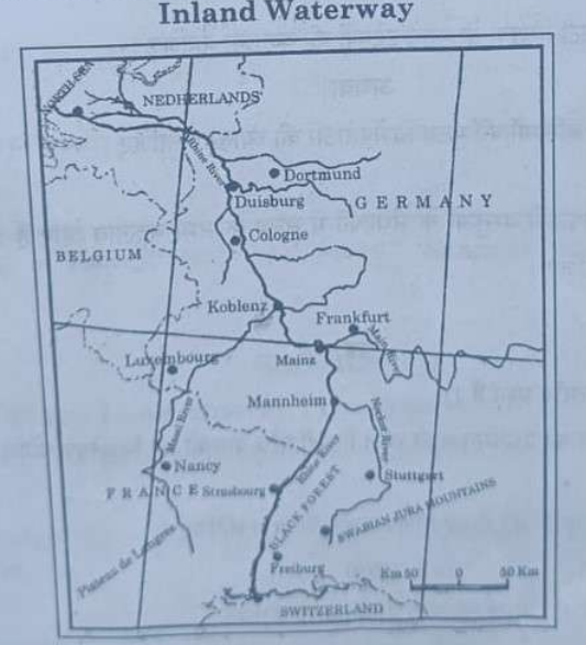
(19.1) Identify the given inland waterway and write its name.
(19.2) Mention its two tributaries joining from East.
(19.3) Write the names of terminal ports of the given waterways.
Note: The following question is for Visually Impaired Candidates only in lieu of Q. No. 19.
Explain the importance of inland waterways as the means of transportation in the world.
Ans: Inland waterways, such as rivers, canals, lakes, and reservoirs, play a significant role in transportation for several reasons:
-
Cost-Effective: Inland waterway transport is often more cost-effective compared to other modes of transportation, especially for bulk goods. It requires less fuel and infrastructure maintenance than road or rail transport.
-
Environmentally Friendly: Water transport is one of the most environmentally friendly modes of transportation, producing fewer emissions per ton of cargo transported compared to road or air transport. It also helps reduce traffic congestion and road accidents.
-
Efficient for Bulk Cargo: Inland waterways are particularly efficient for transporting bulk cargo, such as grains, coal, ores, and petroleum products. They can carry large quantities of goods in a single voyage, reducing the overall transportation costs.
-
Accessibility: Inland waterways provide access to areas that are not easily reachable by road or rail, especially in remote or landlocked regions. They can also connect to major ports, allowing for seamless transportation of goods between different modes of transport.
-
Reliability: Water transport is relatively less affected by weather conditions compared to other modes of transportation. Rivers and canals are typically navigable throughout the year, providing a reliable means of transportation.
-
Historical and Cultural Significance: Inland waterways have played a crucial role in the development of civilizations and trade routes throughout history. They are often associated with cultural heritage and are important for tourism and recreation.
20. (a) "Nature and human are inseparable elements in all geographical studies." Examine the statement.
Ans: Nature and humans are inseparable. The earth is the home of mankind. It may be in different forms. All types of life supports are provided by nature. They directly depend on nature. Nature and humans are inseparable and should be seen holistically. Physical features are described in metaphors using symbols from the human anatomy.
For example:- face of the earth, a nose of the glacier, eye of the storm, mouth of the river, neck of the isthmus, the profile of soil, etc.
OR
(b) Examine the main aspects of environmental determinism.
Ans: Environmental determinism is a theory that suggests that human behavior, culture, and societal development are primarily shaped by the physical environment. Here are the main aspects of environmental determinism:
-
Geographical Influences: Environmental determinism posits that factors such as climate, terrain, and resources heavily influence the development of human societies. For example, societies in arid regions may develop nomadic lifestyles due to the scarcity of water and resources.
-
Cultural Development: According to this theory, the physical environment directly impacts cultural practices and societal norms. For instance, societies in cold climates might develop a culture that values hard work and thriftiness to survive harsh winters.
-
Technological Advancement: Environmental determinism suggests that the availability of resources in an environment can influence the technological advancement of a society. For example, societies with access to abundant natural resources might develop advanced technologies for agriculture or transportation.
-
Economic Systems: The theory proposes that the physical environment plays a crucial role in shaping economic systems. For instance, societies in fertile agricultural regions might develop agrarian economies, while those in resource-rich areas might focus on mining or forestry.
-
Political and Social Structures: Environmental determinism suggests that the physical environment can influence the political and social structures of a society. For example, societies located in isolated regions might develop more insular political systems to protect themselves from external threats.
-
Criticism and Modern Views: Environmental determinism has been widely criticized for oversimplifying the complexities of human behavior and culture. Modern views emphasize the role of human agency and social factors in shaping societies, alongside environmental influences.
21. Explain the main features of periodic markets in rural areas of the world.
Ans: Periodic markets, also known as rural markets or haats, are an integral part of the economic and social fabric of rural areas in many parts of the world. These markets are characterized by several key features:
-
Irregular Frequency: Periodic markets do not operate daily like conventional markets but instead have fixed days of the week or month when they are open. This irregularity is often tied to local traditions, religious practices, or agricultural cycles.
-
Temporary Nature: These markets are temporary in nature, set up for a specific duration, such as a day or a few days, and then dismantled until the next scheduled market day.
-
Location: They are typically located at a central point in the region, making them accessible to people from surrounding villages and hamlets. This central location often has historical significance or is strategically chosen for its accessibility.
-
Goods and Services: A wide variety of goods and services are traded in periodic markets, including agricultural produce, livestock, handicrafts, textiles, household items, and even services like haircuts and medical consultations.
-
Social and Cultural Functions: These markets serve as important social hubs where people from different villages and communities gather not only to buy and sell goods but also to socialize, exchange news and ideas, and maintain social ties.
-
Economic Importance: Periodic markets play a crucial role in the local economy, providing livelihoods for traders, farmers, artisans, and service providers. They also contribute to the circulation of money in rural areas.
22. (a) Explain the main objectives of 'Smart Cities Mission' in India.
Ans: The 'Smart Cities Mission' in India was launched in 2015 with the aim of developing cities that provide core infrastructure, a clean and sustainable environment, and a high quality of life to their citizens through the application of smart solutions. The main objectives of the Smart Cities Mission include:
-
Core Infrastructure Development: To ensure availability of basic infrastructure such as adequate water and electricity supply, sanitation, efficient urban mobility and public transport, affordable housing, and robust IT connectivity.
-
Sustainable Environment: To promote sustainable urban development by adopting measures such as efficient waste management, promoting use of renewable energy, and enhancing green cover and open spaces.
-
Quality of Life: To improve the overall quality of life for citizens by providing better healthcare, education, safety and security, and recreational facilities.
-
Smart Solutions: To use technology and innovation to improve governance and service delivery, enhance efficiency in urban operations, and create a more inclusive and participatory environment for citizens.
-
Economic Development: To promote economic activities and employment opportunities by creating a conducive environment for businesses to thrive and by promoting entrepreneurship and skill development.
-
Inclusive Development: To ensure that the benefits of urban development are equitably shared among all sections of society, including the poor and marginalized.
OR
(b) Explain the main features of the dispersed settlements in India.
Ans: Three characteristics of dispersed settlement in India are :
(i) It appears in the form of isolated huts or hamlets of few huts in remote jungles.
(ii) It also appears on small with farms or pasture on the slopes.
(iii) Its extreme dispersion is caused by extremely fragmented nature of the terrain and land resource base of habitable areas.
23. "The composition of commodities in India's international trade has been undergoing a change over the years." Examine the statement with examples.
Ans: The share of agriculture and allied products has declined, whereas, shares of petroleum and crude products and other commodities have increased.
The shares of ore minerals and manufactured goods have largely remained constant over the years.
The decline in traditional items is largely due to the tough international competition. Amongst the agricultural products, there is a decline in the export of traditional items, such as coffee, cashew, etc., though an increase has been registered in floricultural products, fresh fruits, marine products and sugar, etc.
Engineering goods have shown a significant growth in the export. China and othe East Asian countries are our major competitors. Gems and jewellery contributes a larger share of India’s foreign trade.
India faced serious food shortage during 1950s and 1960s. The major item of import at that time was foodgrain, capital goods, machinery and equipment. The balance of payment was adverse as imports were more than export in spite of all the efforts of import substitution. After 1970s, foodgrain import was discontinued due to the success of Green revolution but the energy crisis of 1973 pushed the prices of petroleum, and import budget was also pushed up.
Foodgrain import was replaced by fertilisers and petroleum. Machine and equipment, special steel, edible oil and chemicals largely make the import basket. Examine the changing pattern of imports in Table 8.4 and try to comprehend the shifts.
The equipment manufacturers of metals and machine tools were the main items of capital goods. Import of food and allied products declined with a fall in imports of edible oils. Other major items of India’s import include pearls and semi-precious stones, gold and silver, metalliferrous ores and metal scrap, non- ferrous metals, electronic goods, etc.
24. Analyse any five factors affecting world distribution of population.
Ans: The world distribution of population is influenced by a variety of factors, including:
-
Physical Factors: These include factors like climate, terrain, and natural resources. People tend to settle in areas with temperate climates, fertile soil, and access to water for agriculture. For example, the majority of the world's population lives in the Northern Hemisphere, where there are more landmasses with suitable climates and resources.
-
Economic Factors: Economic opportunities play a significant role in population distribution. People are more likely to live in areas with good job prospects, access to markets, and infrastructure. Urban areas, for example, tend to have higher populations due to the concentration of economic activities.
-
Cultural and Social Factors: Cultural and social factors, such as language, religion, and family ties, can influence where people choose to live. For example, people may be more likely to live in areas where their cultural or religious practices are predominant.
-
Political Factors: Political factors, such as government policies, stability, and conflicts, can also impact population distribution. Political instability or conflict can force people to migrate to other areas, while government policies can encourage or discourage settlement in certain regions.
-
Technological Factors: Technological advancements, such as transportation and communication technologies, can also influence population distribution. Improved transportation makes it easier for people to move to and settle in different areas, while communication technologies can make remote areas more accessible and attractive for settlement.
25. (a) Examine the main characteristics of Co-operative Farming in the world.
Ans: Co-operative farming, also known as co-operative agriculture or agricultural co-operatives, is a form of collective farming where farmers pool their resources to jointly manage their farms. The main characteristics of co-operative farming in the world include:
-
Ownership and Control: Co-operative farms are owned and managed by the members themselves, who have equal voting rights regardless of their contribution to the co-operative.
-
Pooling of Resources: Members pool their land, labor, capital, and sometimes machinery to collectively operate the farm, enabling them to achieve economies of scale and reduce costs.
-
Democratic Governance: Co-operative farms are governed democratically, with decisions made collectively by the members through a democratic voting process.
-
Profit-Sharing: Profits generated by the co-operative are distributed among the members based on their contribution or according to a predetermined formula.
-
Risk-Sharing: Risks such as crop failure, price fluctuations, or natural disasters are shared among the members, reducing individual risk exposure.
-
Social Benefits: Co-operative farming promotes social cohesion and community development by fostering cooperation and mutual support among members.
-
Education and Training: Co-operatives often provide education and training to their members to improve agricultural practices, increase productivity, and enhance sustainability.
-
Market Access: By pooling resources, co-operatives can access markets more effectively, negotiate better prices for their produce, and reduce dependence on middlemen.
-
Sustainability and Environmental Conservation: Co-operatives often emphasize sustainable agricultural practices and environmental conservation to ensure the long-term viability of their farms.
-
Legal Structure: Co-operative farming is governed by specific legal frameworks in different countries, which define the rights and responsibilities of members, as well as the governance and management structure of the co-operative.
OR
(b) Examine the main characteristics of Dairy Farming in the world.
Ans: Dairy farming is a significant agricultural activity worldwide, characterized by several key features:
-
Livestock: Dairy farming primarily involves the raising and breeding of cattle, specifically dairy cows, for milk production. Other animals like goats and sheep are also raised for dairy in some regions.
-
Milk Production: The main goal of dairy farming is to produce milk, which is then processed into various dairy products such as milk, cheese, butter, and yogurt.
-
Nutritional Requirements: Dairy cows require a balanced diet rich in nutrients to maintain their health and maximize milk production. This includes a mix of grains, forages, and protein supplements.
-
Housing and Facilities: Dairy cows are housed in barns or sheds equipped with milking parlors. These facilities provide protection from harsh weather conditions and ensure the cows are comfortable.
-
Milking Process: Dairy cows are milked multiple times a day using automated milking machines or manual methods. Hygiene is crucial during this process to maintain milk quality.
-
Breeding and Genetics: Dairy farmers often use selective breeding to improve milk production, focusing on traits like milk yield, disease resistance, and calving ease. Artificial insemination is commonly used to introduce desirable genetic traits.
-
Health and Welfare: Dairy farmers are responsible for ensuring the health and welfare of their animals, including regular veterinary care, vaccination programs, and providing a clean and comfortable environment.
-
Sustainability and Environmental Impact: Modern dairy farming practices are increasingly focused on sustainability, including efficient resource use, waste management, and reducing environmental impact, such as greenhouse gas emissions and water pollution.
-
Economic Importance: Dairy farming is a significant sector in many economies, providing employment and income for millions of people globally. It also plays a crucial role in food security and nutrition.
26. Differentiate the small and large scale manufacturing industries in the world.
Ans:
| Small Scale Industries | Large Scale Industries |
| 1. Its manufacturing place (workshop) is outside the home/cottage of the producer. | Large scale industry is totally market-oriented industry, involving large scale production and technologically advanced methods of production of goods in large factory set up. |
| 2. It uses local raw materials, simple power-driven machines, and skilled labour. | It involves a large market, various raw materials, enormous energy, specialized workers, advanced technology, assembly- |
| 3. Countries like India, China, Indonesia and Brazil, etc. have developed labour-intensive small scale manufacturing in order to provide employment to their population. | This kind of manufacturing developed in the last 200 years, in the United Kingdom, north-eastern U.S.A. and Europe. |
27. (a) "The distribution of urban population over India has wide variations." Examine the statement.
Ans: The statement "The distribution of urban population over India has wide variations" suggests that the distribution of urban population across different regions of India varies significantly. This variation can be examined through several factors:
-
Regional Disparities: Urban population distribution can vary greatly from one state or region to another. For example, states like Maharashtra, Tamil Nadu, and Uttar Pradesh have large urban populations concentrated in major cities, while states in the northeast or central India may have lower urban populations and different settlement patterns.
-
Population Density: Urban areas in India vary in population density. Some cities like Mumbai and Delhi are densely populated, while others may have lower population densities despite being classified as urban.
-
Economic Development: Urban population distribution often reflects economic development. Regions with higher levels of economic development tend to have larger and more concentrated urban populations, as cities attract migrants seeking better economic opportunities.
-
Infrastructure and Services: Disparities in urban population distribution can also be attributed to variations in infrastructure and services. Cities with better infrastructure and amenities tend to attract more people, leading to higher urban populations.
-
Historical Factors: Historical factors such as colonial urban planning, ancient trade routes, and cultural practices can also influence the distribution of urban population in India. Cities that were historically important tend to have larger urban populations.
-
Government Policies: Government policies related to urban development, industrialization, and regional planning can also impact the distribution of urban population. Policies that promote industrial growth in certain regions, for example, can lead to a higher concentration of urban population in those areas.
OR
(b) "If development is not engendered, it is endangered." Examine the statement in the context of inclusive development.
Ans: The statement "If development is not engendered, it is endangered" underscores the critical importance of gender inclusivity in development efforts. Inclusive development recognizes that development outcomes must benefit everyone in society, regardless of gender, and that failure to do so can jeopardize the sustainability and effectiveness of development initiatives. Here's how the statement can be examined in the context of inclusive development:
-
Social Inclusion: Gender inclusivity is a key aspect of social inclusion. Development that does not address gender disparities risks leaving behind a significant portion of the population, particularly women and girls, leading to societal imbalances and tensions.
-
Economic Development: Gender equality is not just a moral imperative but also an economic one. Women's participation in the economy is crucial for sustainable economic growth. Neglecting this aspect of development can hinder overall economic progress.
-
Health and Education: Gender-inclusive development ensures that women have access to healthcare and education, which are fundamental rights. Failing to prioritize these aspects can lead to higher rates of maternal mortality, lower levels of education among girls, and overall poorer health outcomes.
-
Political Participation: Inclusive development involves ensuring that women have equal opportunities for political participation. Excluding women from decision-making processes can lead to policies that do not adequately address the needs of all citizens.
-
Sustainability: Gender-inclusive development is often more sustainable in the long term. By empowering women and ensuring their participation in development processes, communities are better equipped to address challenges and adapt to changes.
-
Community Development: Inclusive development recognizes that communities thrive when everyone is included. Ignoring gender dynamics can lead to social unrest and conflict within communities.
28. (a) Describe any two sources of air pollution in India and suggest any three measures to overcome the air pollution.
Ans: Air pollution in India arises from various sources, but two significant contributors are vehicular emissions and industrial activities.
-
Vehicular Emissions: The rapid increase in the number of vehicles, especially diesel-powered ones, contributes significantly to air pollution. Diesel vehicles emit particulate matter, nitrogen oxides, carbon monoxide, and volatile organic compounds, which degrade air quality.
-
Industrial Activities: Industries, particularly those using coal and other fossil fuels, release a range of pollutants, including sulfur dioxide, nitrogen oxides, and particulate matter. Poorly regulated industries often do not have adequate pollution control measures in place.
To overcome air pollution, several measures can be implemented:
-
Promotion of Clean Transportation: Encouraging the use of electric vehicles, promoting public transportation, and improving vehicle emission standards can reduce vehicular emissions.
-
Stringent Pollution Control Measures for Industries: Implementing strict emission norms for industries, promoting cleaner production technologies, and regular monitoring of industrial emissions can help reduce pollution from industrial sources.
-
Afforestation and Green Cover: Planting trees and creating green spaces can help absorb pollutants and improve air quality. Additionally, it can reduce the heat island effect in urban areas, which contributes to local air pollution.
OR
(b) Describe any two sources of water pollution in India. Suggest any three measures to overcome the water pollution.
Ans: Two significant sources of water pollution in India are industrial effluents and untreated sewage:
-
Industrial Effluents: Industries release various pollutants into water bodies, including heavy metals, chemicals, and organic compounds. These can contaminate water, making it unsuitable for human use and harmful to aquatic life.
-
Untreated Sewage: Lack of proper sewage treatment facilities results in the direct discharge of untreated sewage into rivers and other water bodies. This sewage contains pathogens, nutrients, and other contaminants that degrade water quality.
Measures to overcome water pollution:
-
Improved Sewage Treatment: Implementing better sewage treatment facilities can significantly reduce the amount of untreated sewage entering water bodies. This includes building more treatment plants and upgrading existing infrastructure.
-
Regulation and Enforcement: Stricter regulations and their effective enforcement can help control industrial pollution. Industries must treat their effluents before discharge and adhere to prescribed pollution control standards.
-
Public Awareness and Participation: Educating the public about the importance of clean water and involving them in water management can lead to better conservation practices and pollution prevention efforts.
29.1 Name the major seaport located on the west coast of Canada.
Ans: Port of Vancouver
29.2 Name the international airport of Chile.
Ans: Arturo Merino Benítez International Airport
29.3 Name the canal connecting the Red Sea and the Mediterranean Sea.
Ans: Suez Canal
29.4 Name an important area of subsistence gathering in Africa.
Ans: The Kalahari Desert
29.5 Name an area of nomadic herding in Asia.
Ans: Tibetan Plateau
29.6 Name the eastern terminal station of Trans-Canadian Railway.
Ans: Halifax
29.7 Name an area of extensive commercial grain farming in Australia.
Ans: Murray-Darling Basin
30. Locate and label any five of the following geographical features with appropriate symbols on the given political outline map of India :
30.1 A state leading in the production of coffee.
Ans: Karnataka
30.2 An oil refinery in Uttar Pradesh.
Ans: Mathura Refinery
30.3 An important coal mining area in West Bengal.
Ans: Raniganj Coalfield.
30.4 A major seaport along the coast of Goa.
Ans: Mormugao Port Authority
30.5 A state with highest population density.
Ans: Bihar
30.6 An international airport in Gujarat.
Ans: Sardar Vallabhbhai Patel International Airport (AMD)
30.7 An iron-ore mining area in Chhattisgarh.
Ans: Bailadila Iron Ore Mine
CBSE Class 12 Chemistry Answer Key 2024 and Question Papers, Download PDF All SETs


 Quiz
Quiz