-
Question 1
5 / -1
Which of the following sources of energy has the maximum potential in India?
Solution
- Energy is the capacity of a physical system to perform work. Energy exists in several forms such as heat, kinetic or mechanical energy, light, potential energy, electrical, or other forms. Energy is the ability to do work. Energy sources could be classified as Renewable and Non-renewable.

Solar Energy has the maximum potential in India
Solar Energy
- Sun is the primary source of energy.
- Sunlight is a clean, renewable source of energy.
- It is a sustainable resource, meaning it doesn't run out, but can be maintained because the sun shines almost every day.
- More and more people are wanting to use clean, renewable energy such as solar, wind, geothermal steam, and others.
- It is called 'Green Power'.
- It lights our houses by day, dries our clothes and agricultural produce, keeps us warm and lots more. Its potential is however much larger
Advantages
- It is a perennial, natural source and free
- It is available in plenty
- It is non-polluting
- It does not emit any greenhouse gases.
- Solar energy offers decentralization in most (sunny) locations, meaning self-reliant societies.
- One of the biggest advantages of solar energy is the ability to avoid the politics and price volatility that is increasingly characterizing fossil fuel markets.
- It doesn’t result in the destruction of forests and eco-systems that occurs with most fossil fuel operations.
Disadvantages
- Dependent on change in seasons/weather – hence they may not be used always
- Requires high initial investments for productive use
- Solar systems don’t work at night directly but the battery bank, which stores energy during the day-time can be used during the night.
- Solar electricity storage technology has not reached its potential yet.
- Solar panels are bulky. This is particularly true of the higher-efficiency, traditional silicon crystalline wafer solar modules.

Wind Energy
- The wind is the natural movement of air across the land or sea. The wind when used to turn the blades of a windmill turns the shaft to which they are attached. This movement of the shaft through a pump or generator produces electricity.
Advantages
- It is environment friendly
- Its freely and abundantly available
- Disadvantages
- High investment requirement
- Wind speed is not uniform all the time which affects power generated
Ocean energy
- Oceans cover 70 per cent of the earth’s surface and represent an enormous amount of energy. Although currently under-utilized, Ocean energy is mostly exploited by just a few technologies: Wave, Tidal, Current Energy, and Ocean Thermal Energy.
Tidal Energy
- The tidal cycle occurs every 12 hours due to the gravitational force of the moon. The difference in water height between low tide and high tide is potential energy. Similar to traditional hydropower generated from dams, tidal water can be captured in a barrage across an estuary during high tide and forced through a hydro-turbine during low tide.
- The capital cost for tidal energy power plants is very high due to high civil construction and high power purchase tariff. To capture sufficient power from the tidal energy potential, the height of high tide must be at least five meters (16 feet) greater than low tide. The total identified potential of Tidal Energy is about 12455 MW, with potential locations identified at Khambat & Kutch regions, and large backwaters, where barrage technology could be used.
Therefore Option 1 is the correct answer.
-
Question 2
5 / -1
Which of the following is the terminal stations of East- west Corridor?
Solution
The correct answer is Both 1 and 2.
 Key Points
- The two terminals of the East-West corridor are Silcher in Assam and Porbandar in Gujarat.
- The East-West corridor of the golden quadrilateral is 3,300 kilometers in length and connecting Silchar and Porbandar.
- National Highways 27 is associated with the East-West corridor.
National Highways
- According to the Ministry of Roads, Transport and Highways, there are 599 National Highways in India.
- Over a period of time, the numbering of National Highways in India has been renewed.
- The Ministry has released details of National Highways in the country on its official website.
- The National highways are a network of trunk roads owned by the Ministry of Road Transport and Highways. It is constructed and managed by the National Highway Authority of India (NHAI), the National Highways and Infrastructure Development Corporation Limited (NHIDCL), and the public works departments (PWD) of state governments.
-
Question 3
5 / -1
The High Yielding Varieties (HYVs) of wheat were first developed in ________.
Solution
The correct answer is option 4, i.e. Mexico.
- In Mexico, Prof. Norman Borlaug and his associates developed new varieties of wheat which were early-maturing, highly productive and disease resistant and these varieties were imported and planted in selected regions of India having adequate irrigation facilities.
- It was conclusively demonstrated that the yields from the new varieties exceeded 25 to 100 per cent compared to the yields from traditional varieties.
- High Yielding Variety Seeds (HYV seeds) are seeds that are of better quality than normal quality seeds.
- The produce from these seeds is a bit more compared to the normal ones.
- These seeds are a better option of seeds in order to obtain a healthy and surplus crop.
- These seeds have a good immune system to fight with insects and other diseases.
-
Question 4
5 / -1
Which of the following statement is related to "Pawan Hans?"
Solution
The correct answer is option 1.
Key PointsPawan Hans
- Pawan Hans is the helicopter service operating in hilly areas and is widely used by tourists in north eastern sector.
- Pawan Hans Limited also provides helicopter services to petroleum sector as well as to tourists.
- Pawan Hans is a joint venture by the government of India and the state-owned ONGC which holds a 49 per cent stake in the company.
- Government-owned helicopter service Pawan Hans has been sold to Star9 Mobility Pvt Ltd.
- It helps them reach offshore sites and inaccessible areas of the north-eastern states and interior parts of Jammu and Kashmir, Himachal Pradesh, and Uttarakhand.
-
Question 5
5 / -1
Which of the following crops is grown throughout the year in the southern states of India?
Solution
The correct answer is Rice.
- Rice crops are grown throughout the year in the southern states of India.
Key Points
- Rice is a Kharif crop.
- Rice growing in India varies for different parts of the country based on the varying altitude and climate.
- Factors of growth: Temperature, rainfall, soil types, water availability.
- Since a mean temperature is found in the eastern and western regions which are favourable for rice cultivation it is grown throughout the year.
- In northern and western parts only one crop is grown owing to high rainfall and low winter temperature from May to November.
 Additional Information
| Name | Details |
| Maize | - Maize is a cereal grain.
- In India, it is grown in the Kharif season with high temperatures and rainfall.
|
| Finger millet | - Finger millet is also known as ragi is grown as grain or forage.
- It is small millet
- In India, it is grown in different seasons in different parts of the country.
|
| Sorghum | - It is known as great millet.
- In India, it is grown in different seasons in different parts of the country
|
-
Question 6
5 / -1
'It can be placed and located at any place' - this line is appropriate for which of the following industries?
Solution
The industry refers to economic activity that is concerned with the production of goods, extraction of minerals, or the provision of services. Industries can be classified on the basis of raw materials, size, and ownership.

Footloose industry:
- Footloose industries can be located in a wide variety of places.
- They are not dependent on any specific raw material, weight loss, or otherwise.
- They largely depend on component parts which can be obtained anywhere.
- Diamond and Computer chips industries are types of footloose industries.
- The cotton textile industry uses a non-weight-losing raw material and is generally located in a large urban center, e.g. Mumbai, Ahmedabad, Surat, etc. but it is not a footloose industry as it requires agro-based raw material.
- These are called footloose as these types of industries are prone to relocation.
Hence, the line 'It can be placed and located at any place' - is appropriate for the footloose industry.

Basic industries:
- Basic and non-basic are the two broad industry categories.
- Basic industries consist of small and large businesses that sell primarily to external customers.
- Basic industries are those which supply their raw materials to industries that manufacture other goods.
- An example is the iron and steel industry which supplies steel to the automobile industry.
- These are the industry that produces materials that are supplied to other industries, and which is important in a country's economy
Small scale industries:
- Small scale industries (SSI) are those industries in which manufacturing, providing services, productions are done on a small scale or micro scale.
- For example, these are the ideas of Small scale industries: Napkins, tissues, chocolates, toothpicks, water bottles, small toys, papers, pens.
Iron and steel industry:
- This is a feeder industry whose products are used as raw material for other industries.
- The inputs for the industry include raw materials such as iron ore, coal, and limestone, along with labor, capital, site, and other infrastructure.
-
Question 7
5 / -1
Which of the following states are leading producers of Manganese in India?
Solution

Manganese:
- Manganese is an important raw material for smelting iron ore and is also used for manufacturing ferroalloys.
- Manganese deposits are found in almost all geological formations, however, it is mainly associated with Dharwar system.
- Odisha was the leading producer of Manganese, presently it is holding the third position.
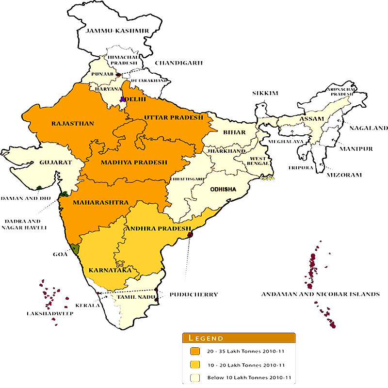
- Madhya Pradesh, the leading manganese ore producing State, accounted for 33% of the total production in 2018-19, followed by Maharashtra (27%) and Odisha (16%)
- Major mines in Odisha are located in the central part of the iron ore belt of India, particularly in Bonai, Kendujhar, Sundergarh, Gangpur, Koraput, Kalahandi, and Bolangir.
- Karnataka is another major producer and here the mines are located in Dharwar, Ballari, Belagavi, North Canara, Chikkmagaluru, Shivamogga, Chitradurg, and Tumakuru.
- Maharashtra is also an important producer of manganese, which is mined in Nagpur, Bhandara, and Ratnagiri districts.
- The disadvantage to these mines is that they are located far from steel plants.
- The manganese belt of Madhya Pradesh extends in a belt in Balaghat-Chhindwara-Nimar-Mandla and Jhabua districts.
- Telangana, Goa, and Jharkhand are other minor producers of manganese.
Hence, option 1 is the correct answer.
-
Question 8
5 / -1
Which of the following is the longest National Highway?
Solution
The correct answer is NH7.
Key PointsNational Highway
- National Highway 7 is renamed as National Highway 44.
- The longest National Highway is NH 44, which runs between Srinagar in Jammu and Kashmir and Kanyakumari in Tamil Nadu.
- The shortest National Highway is NH 766EE, which spans 4.27 km (2.65 mi), from Hettikeri to Belekeri port in Karnataka.
- The Leh–Manali Highway connecting Leh in Ladakh to Manali in Himachal Pradesh is the world’s second highest-altitude motorable highway.
- The first National Highway in India was the old NH-1. It linked the National capital Delhi to Attari in Punjab near Indo-Pak Border. As per the new numbering system, NH 1 runs between Union Territories of Jammu, Kashmir, and Ladakh.
Additional InformationNational Highways Authority of India (NHAI)
- National Highways Authority of India (NHAI) was set up under NHAI Act, 1988.
- It is under the administrative control of the Ministry of Road Transport and Highways.
- It has been entrusted with the National Highways Development Project, along with other minor projects for development, maintenance and management.
- National Highways Development Project (NHDP) is a project to upgrade, rehabilitate and widen major highways in India to a higher standard. The project was started in 1998.
-
Question 9
5 / -1
Choose the correct statement related to Oil India Limited (OIL):
1. Oil India Limited operates under the administrative set up of the Ministry of Petroleum and Natural Gas.
2. It is engaged in the exploration, production and transportation of crude oil and natural gas.
3. It was incorporated in 1969 as a company.
Solution
The correct answer is 1 and 2
Key PointsOil India Limited (OIL)
- Oil India Limited (OIL) operates under the administrative setup of the Ministry of Petroleum and Natural Gas. Hence, statement 1 is correct.
- It is engaged in the exploration, production, and transportation of crude oil and natural gas. Hence, statement 2 is correct.
- It was incorporated in 1959 as a company. Hence, statement 3 is not correct.
Functions:
- It constructed Asia’s first cross-country pipeline covering a distance of 1,157 km from Naharkatiya oilfield in Assam to Barauni refinery in Bihar.
- It was further extended up to Kanpur in 1966.
- It has also constructed another pipeline in the western region of India of which Ankleshwar-Koyali, Mumbai High- Koyali and Hazira-Vij aipur-Jagdishpur (HVJ) are the most important.
- Recently, a 1256 km long pipeline connecting Salaya (Gujarat) with Mathura (U.P.) has been constructed.
- It supplies crude oil from Gujarat to Punjab (Jalandhar) via Mathura.
- OIL is in the process of constructing of 660 km long pipeline from Numaligarh to Siliguri
-
Question 10
5 / -1
In which of the following regions are Pygmies found?
Solution
The correct answer is Equatorial forest.
- Short people known as pygmies are scattered across equatorial Africa, where they speak various languages, inhabit different types of forests, and hunt and gather food in diverse ways.
- A new study shows the pygmies of Western Central Africa descended from an ancestral population that survived intact until 2800 years ago when farmers invaded the pygmies' territory and split them apart.
Key Points
- The equatorial region covers only 6 % of the Earth's surface. It contains more than 1/2 of the world's plant and animal species. It is also known as the Rain forest, Selvas, or the Evergreen forest. The equatorial region extends from 0° to 10° in the North as well as South. It is distributed in the continents of South America, Africa, and Asia.
Additional Information
- Sahara is the largest desert in the world. The Sahara is bordered in the west by the Atlantic Ocean, in the north by the Atlas Mountains and the Mediterranean Sea, in the east by the Red Sea, and in the south by the Sahel—a semiarid region that forms a transitional zone between the Sahara to the north and the belt of humid savannas to the south.
- The Kalahari Desert is a large semi-arid sandy savannah in Southern Africa extending for 900,000 square kilometers, covering much of Botswana, and parts of Namibia and South Africa.
- The Pampas, vast plains extending westward across central Argentina from the Atlantic coast to the Andean foothills, bounded by the Gran Chaco (north) and Patagonia (south).
-
Question 11
5 / -1
The subject matter of geography is studied through specialised number of branches. Which of the following does NOT fall under the category of Human Geography?
Solution
Geo “ Earth” and Graphy “ to describe” the literal meaning of geography is to describe the earth’s surfaces.
- In other words “Geography is largely the study of the interaction of all physical and human phenomena and landscapes created by such interactions.”
- It is about how, why, and where human and natural activities occur and how these activities are interconnected.
Key PointsVariable phenomena on the earth’s surface can be treated separately or in the association. They are classified and categorized into physical phenomena and human phenomena. Thus geography has three main branches :
- Physical Geography: Physical geography is concerned with the study and explanation of the physical phenomenon, encompassing the other such fields like geology, meteorology, zoology, and chemistry
- Human Geography: Human Geography is the synthetic study of the relationship between human societies and the earth’s surface.
- Human geography has a number of sub-branches.
- Anthropogeography: It largely deals with racial phenomena in their spatial context.
- Cultural geography: It focuses on the origin, components, and impact of human cultures, both material and non-material.
- Economic geography: It refers to the study of the location and distribution of economic activities at the local, regional, national, and world scales.
- Political geography: It is the study of political phenomena in their spatial context. The main focus remains on the creation and transformation of the political and administrative region.
- Historical geography: Spatial and temporal trends of geographical phenomena are studied in Historical geography.
- Social geography: It is the analysis of social phenomena in space. Poverty, health, education, and livelihood are some important fields of study in social geography.
- Population geography: It is the study of various dimensions of the population like its population distribution density, composition, fertility, mortality, migration, etc.
- Settlement geography: It is the study of Rural/Urban settlements, their size, distribution, functions, hierarchy, and various other parameters of the settlement system.
- Regional Geography: Aspects such as delineation of regions, their geographical characteristics, and processes of change constitute regional geography.
Hence, environmental geography is not a part of Human Geography.
-
Question 12
5 / -1
Very high grade Iron Ore is found in which district?
Solution
The correct answer is Durg and Baster.
- Coal and iron are among the more important of the minerals of Madhya Pradesh.
- Manganese is another important mineral that occurs in Madhya Pradesh in the Balaghat and Chhindwara districts.
Key Points
- The Madhya Pradesh and Chattisgarh belt is the largest producer of iron ore in India.
- Bulk of the supplies comes from Dharwad rocks of Durg, Bastar and Jabalpur districts.
- The Bailadila range in Bastar and Dhalli-Rajhara range in Durg are the main producing regions.
- The haematite ore is rich in iron contents (65 to 70 per cent).
- The Bailadila mines are the largest mechanized iron ore mines in Asia.
- The other iron mining centres are in Raigarh, Bilaspur, Mandia, Balagat and Surguja districts.
-
Question 13
5 / -1
Identify the crop on the basis of the following characteristics:
1. India is the largest producer as well as the consumer in the world.
2. They are grown preferably on Sandy-loamy soil.
3. Top Producing States: Madhya Pradesh > Rajasthan > Maharashtra > Uttar Pradesh > Karnataka.
Solution
The correct answer is Pulses.
Key Points
- Pulses
- Temperature: Between 20-27°C
- Rainfall: Around 25-60 cm.
- Soil Type: Sandy-loamy soil.
- Top Pulses Producing States: Madhya Pradesh > Rajasthan > Maharashtra > Uttar Pradesh > Karnataka.
- India is the largest producer as well as the consumer of pulses in the world.
- These are the major source of protein in a vegetarian diet.
- Major pulses grown in India are Tur (Arhar), Urad, moong, Masur, peas, and gram.
- Being leguminous crops, all these crops except Arhar help in restoring soil fertility by fixing nitrogen from the air. Therefore, these are mostly grown in rotation with other crops.
- National Food Security Mission for Pulses, Pulses Development Scheme, and Technological Mission on Pulses are a few of the government’s plans to support pulses production.
- Hence, Option 3 is correct.
-
Additional Information
- Rice
- Temperature: Between 22-32°C with high humidity.
- Rainfall: Around 150-300 cm.
- Soil Type: Deep clayey and loamy soil.
- Top Rice Producing States: West Bengal > Punjab > Uttar Pradesh > Andhra Pradesh > Bihar.
- It is the staple food crop of the majority of Indian people. India is the second-largest producer of rice in the world after China. In states like Assam, West Bengal, and Odisha, three crops of paddy are grown in a year. These are Aus, Aman, and Boro. National Food Security Mission, Hybrid Rice Seed Production, and Rashtriya Krishi Vikas Yojana are few government initiatives to support rice cultivation.
- Wheat
- Temperature: Between 10-15°C (Sowing time) and 21-26°C (Ripening & Harvesting) with bright sunlight.
- Rainfall: Around 75-100 cm.
- Soil Type: Well-drained fertile loamy and clayey loamy (Ganga-Satluj plains and black soil region of the Deccan)
- Top Wheat Producing States: Uttar Pradesh > Punjab > Madhya Pradesh > Haryana > Rajasthan.
- India is the second-largest producer after China. This is the second most important cereal crop and the main food crop, in north and north-western India. The success of the Green Revolution contributed to the growth of Rabi crops especially wheat. Macro Management Mode of Agriculture, National Food Security Mission, and Rashtriya Krishi Vikas Yojana are few government initiatives to support wheat cultivation.
- Maize
- Temperature: Between 21-27°C
- Rainfall: High rainfall.
- Soil Type: Old alluvial soil.
- Top Maize Producing States: Karnataka > Maharashtra > Madhya Pradesh > Tamil Nadu > Telangana
- India is the seventh-largest producer worldwide. It is used both as food and fodder. The use of modern inputs such as High-Yielding Variety seeds, fertilizers, and irrigation have contributed to the increasing production of maize. Technology Mission on Maize is one of the government’s initiatives for Maize.
-
Question 14
5 / -1
Which of the following is non-ferrous metal?
Solution
Key PointsNon-ferrous metals:
Hence, Lead is not a non-ferrous metal from the list.
Additional InformationFerrous metals: Ferrous metals include steel, cast iron, and titanium, as well as alloys of iron with other metals (such as stainless steel).
-
Question 15
5 / -1
Dry farming practices are largely found in the areas of
Solution
Dry farming, also called Dryland Farming, the cultivation of crops without irrigation in regions of limited moisture, typically less
Key Points
Dry farming:
- Dry farming is the cultivation of crops in regions with an annual rainfall of less than 75 cm.
- Crop failure is most common due to prolonged dry spells during the crop period.
- These are arid regions with a growing season (period of adequate soil moisture) of less than 75 days.
- 68% of the cultivated area in Indian agriculture comes under dryland.
- It contributes about 44% of the total food production and plays a critical role in India's food security.
- These regions grow hardy and drought-resistant crops such as ragi, bajra, moong, gram, and guar (fodder crops).
Hence, option 3 is the correct answer.
-
Question 16
5 / -1
Majority of the iron ore found in India is of which quality?
Solution
The correct answer is Haematite.
- The majority of the iron ore found in India is of Haematite quality.
Key Points
- Hematite and magnetite are the most prominent of the iron ores found in India.
- Of these two hematite is considered to be the most important iron ore because of its high-grade quality & lumpy nature, which is consumed by a large number of steel & sponge iron industries in the country.
- Iron ores are mainly Magnetite (Fe3O4), Haematite (Fe2O3), Siderite (FeCO3).
Additional Information
- The iron and Steel Industry took birth in India in the year 1870 when Bengal Iron Works Company established its plant at Kulti, West Bengal.
- Large scale iron and steel production was started in 1907 by TISCO established at Jamshedpur (Jharkhand).
- As per the data from the International Iron and Steel Institute (IISI) India is the 7th largest producer of steel in the world.
- At present India is the 5th largest CrudeSteel producing country in the world.
- India is the largest producer of sponge iron in the world.
-
Question 17
5 / -1
Which group of steel plants were established in India before independence?
Solution
Iron and Steel Industry
- It is a feeder industry whose products are used as raw materials for other industries.
- Raw materials include iron ore, coal, and limestone. etc
- lt is considered a heavy industry because all the raw materials, as well as finished goods, are heavy and bulky entailing heavy transportation costs.
- Currently, India is the 2nd largest crude steel producer globally and with a capacity of over 100 million tonnes.
- India is the largest producer of sponge iron in the world.
- Statewise Odisha is the largest producer of steel in India followed by Jharkhand.
- The Government has taken various steps to boost the sector including the introduction of National Steel Policy 2017 and allowing 100 percent Foreign Direct Investment (FDI) in the steel sector under the automatic route.
Key Points| Steel Plant | Description |
| Rourkela Steel Plant | - Rourkela Steel Plant (RSP), in Rourkela, Odisha is the first integrated steel plant in the public sector in India.
- It was set up with West Germany collaboration with an installed capacity of 1 million tonnes.
- On 3 February 1959, then president Rajendra Prasad inaugurated RSP's first blast furnace named 'Parvati'.
|
| Bhilai Steel Plant | - Bhilai Steel Plant is situated in Chhattisgarh.
- Bhilai is a city in the district of Durg.
- The Bhilai Steel Plant (BSP) is India's first and main producer of steel rails.
- It was established in the year 1955.
|
| Durgapur Steel Plant | - Durgapur Steel Plant in West Bengal was set up in collaboration with the government of the United Kingdom and started production in 1962.
- This plant lies in Raniganj and Jharia coal belt and gets iron ore from Noamundi.
|
| Bokaro Steel Plant | - Bokaro Steel plant is located in Bokaro, Jharkhand and was the fourth public sector plant which was established in 1964 with the help of Russia.
- It was later merged with SAIL.
- It is the first Indian steel plant which has been built by using maximum products like equipment, raw material and other things from India itself.
- Currently, it operates 5 blast furnaces and has the capacity to produce 5.8 MT of liquid steel.
- The major products of this plant are hot rolled and cold rolled coils, galvanized clean sheets, hot rolled plates and sheets.
|
| Jamshedpur Steel Plant | - Tata Iron & Steel Company
Limited was founded on
August 26, 1907. - Jamshedpur - Tata Steel Plant is a subsidiary of the Tata Group.
- Among the first steel plants in Asia, which continuously produce steel at the same site for over 100 years.
- Formerly known as Tata Iron and Steel Company Limited (TISCO)
|
| Visvesvaraya Steel Plant | - Visvesvaraya Iron and Steel Plant (VISL), a unit of Steel Authority of India Limited.
- It is a plant involved in the production of alloy steels and pig iron.
- It is located in the city of Bhadravathi, India.
- It was started as the Mysore Iron Works on 18 January 1923 by Sir M Visvesvaraya.
- It is now a steel plant under the jurisdiction of the Steel Authority of India Limited.
|
| IISCO | - IISCO Steel Plant of Steel Authority of India Limited is an integrated steel plant located at Burnpur, a neighbourhood in Asansol city, West Bengal, India.
- Established in 1918, the Indian Iron & Steel Company, once the flagship of the Martin Burn group.
- It was amalgamated with SAIL in 2006 and renamed IISCO Steel Plant.
|
Thus, Jamshedpur, IISCO, Visvesvaraya group of steel plants were established in India before independence.
-
Question 18
5 / -1
Which among the following is/are major functions of the National Highways Authority of India?
Solution
The correct answer is All of the Above.
Key PointsFunctions of NHAI
- Developing, maintaining, and managing National Highways (NH) across the country.
- Collecting fees/tolls on NH, regulating and controlling the plying of vehicles on NH for proper management.
- Developing and providing consultancy and construction services on a national and international level. Also, conducting research activities that help develop, maintain and manage highways or other facilities thereat.
- Advising the Central government on issues related to NH.
- Formulating and implementing schemes for NH development.
- Constructing offices and residential buildings for NHAI employees.
- Providing facilities and amenities to NH users necessary for the smooth flow of traffic on such highways.
-
Question 19
5 / -1
Culturable waste land is a category of land use in India which
Solution
The correct answer is None of the above.
 Important Points
- The culturable waste land is left uncultivated for more than 5 agricultural years.
- It is a category of uncultivable land. So, options 1, 2, and 3 are NOT correct.
Additional Information
- Area sowed more than once in an agricultural year plus the net sown area is known as the Gross cropped area.
-
Question 20
5 / -1
The largest port of India is:
Solution
According to the Ministry of Shipping, 95% of India’s foreign trade is mainly via seaports. These ports play a crucial role in the International North-South Trade Corridor (INSTC), which connects the Indian Ocean to trade with the Eurasian trade corridors and the Arctic.
Mumbai Port:
- The western coast city of Mumbai is home to India’s largest port by size and shipping traffic.
- The port is situated in a natural harbor with water reaching depths of 10-12 meters, allowing easy docking and passage for large cargo ships.
- The Mumbai Port is critical to the Indian economy and trade operations as it handles 20% of the foreign trade.
- It was the first container terminal in India, which handled over 2 million TEU per year.
- It has four jetties that control several imports and exports, including manganese, crude, and petroleum oil, textiles, tobacco, liquid chemicals, leather, and heavy machinery.
Hence, option 2 is the correct answer.
Kandla Port:
- The Kandla Creek area located 90 kilometers away from the Gulf of Kutch is home to the Port of Kandla.
- It is one of the oldest ports in India and was constructed back in the 1950s following the India-Pakistan partition.
- It was the first export processing port in India.
Kolkata Port:
- The Port of Kolkata is the fourth busiest in India and has annual traffic of 796,000 TEU.
- Also dubbed as “Gateway of Eastern India,” the port manages cargo that arrives from Australia and Southeast Asia.
- It utilizes two dock systems - Haldia docks and Kolkata docks.
- It’s a natural river port and can comfortably accommodate ships up to 500 feet in length.
-
Question 21
5 / -1
Which of the following is a non-renewable source of energy?
Solution
CONCEPT:
- Non-renewable sources of energy are those which are exhaustible and cannot be replaced, once they have been used.
- They are also known as conventional sources of energy.
- For example Oil, natural gas, coal, and nuclear energy.
EXPLANATION:
- Fossil fuels are non-renewable sources of energy. Therefore option 3 is correct.
- Hydro, the Sun, and wind are renewable sources of energy.
-
Question 22
5 / -1
Which of the following is NOT an advantage of geothermal energy?
Solution
Geothermal Energy:
The heat that comes from the earth's subsurface is known as geothermal energy.
- It can be present in the minerals and fluids underneath the earth's surface, as well as in the hot molten rock known as magma.
- Mile deep wells are drilled into underground lakes to access steam and hot water, which can then be used to power turbines attached to electricity generators.
- Dry steam, flash, and binary geothermal power plants are the three types of geothermal power plants.
- Hotspots over crust are idea for geothermal energy as more heat can be obtained.
Advantages
- It can be extracted without burning a fossil fuel such as coal, gas, or oil.
- Geothermal fields produce only about one-sixth of the carbon dioxide that a relatively clean natural-gas-fueled power plant produces.
- Binary plants release essentially no emissions.
- Unlike solar and wind energy, geothermal energy is always available, 365 days a year, so reliable source of energy.
- It is a renewable energy source.
- It is least polluting as compared to other conventional energy sources.
The initial cost of geothermal energy is very high, so it's NOT an advantage of geothermal energy.
-
Question 23
5 / -1
Which one of the following indicates a population pyramid with wide base narrowing as the age Cohorts progress?
Solution
Correct Answer: High fertility and high mortality rates.
Key Points
- A Population Pyramid is a graph that shows the age-sex distribution of a given population. It is a graphic profile of the population's residents. Sex is shown on the left/right sides, age on the y-axis, and the percentage of the population on the x-axis. Each grouping (ex: males aged 0-4) is called a cohort.
- A wide base means there are lots of young people, and suggests a high birth rate. A narrow base means a smaller proportion of young people, suggesting a low birth rate. A wide middle, tall pyramid means an aging population, suggesting that there is a long life expectancy.
- There are three main trends in populations that affect the shape of a population pyramid. The first is when there are both high fertility and high mortality rates among younger members. This type of population, known as “expansive,” creates a sharp triangle shape in the graph.
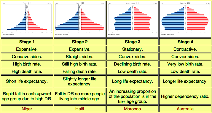

- A sharply tapering pyramid sitting on a broad base, reflecting high fertility and high mortality rates among the younger age groups.
Additional Information
- The Demographic Transition Model was developed by the American demographer Warren Thompson in 1929. DTM depicts the demographic history of a country. It refers to the transition from high birth and high death rates to low birth and low death rates regime as a country develops from a pre-industrial to an industrialized economic system.
-
Question 24
5 / -1
When was the Inland Waterways Authority of India set up?
Solution
The correct answer is 1989.
Key Points
- The Inland Waterways Authority of India was set up in 1986 for the development, maintenance, and regulation of National Waterways in the country.
- At present, there are only three National Waterways in the country.
- Ten other waterways are being considered for up-gradation as National Waterways.
The three national Waterways are:
- National Waterway 1 : The Allahabad-Haldia stretch of the Ganga-Bhagirathi Hooghly river system (1620 km);
- National Waterways 2 : The Sadiya-Dhubri stretch of the Brahmaputra river (891 km);
- National Waterways 3 : The West Coast Canal from Kottapuram to Kollam alongwith Udyogmandal and Champakar canals (205 km).
-
Question 25
5 / -1
The level of urbanisation in India in 2011 was____
Solution
The correct answer is option 2.
Key Points
Urbanisation in India -
- The level of urbanisation is measured in terms of the percentage of the urban population to the total population.
- The level of urbanisation in India in 2011 was 31.16 per cent, which is quite low in comparison to developed countries.
- Hence the correct answer is option 2.
- The total urban population has increased eleven-fold during the twentieth century.
- Enlargement of urban centres and the emergence of new towns have played a significant role in the growth of the urban population and urbanisation in the country.
-
Question 26
5 / -1
Consider the following factors:
1. Raw Materials
2. Power
3. Transport
4. Labour
Which of the factors given above regarding the location of industries is/are not correct?
Solution
The correct answer is None of the above.
Key Points
- The location of industries is influenced by several factors like access to raw materials, power, market, capital, transport, and labour.
- Raw Materials:
- Industries using weight-losing raw materials are located in the regions where raw materials are located like the pulp industry, pig iron industries, etc.
- Raw materials that lose weight after getting converted in pure form are called weight-losing raw material. Eg. Iron ores, coal, etc.
- Therefore, an optimum location for iron and steel industries should be near raw material sources.
- Similarly, industries based on perishable raw materials are also located close to raw material sources.
- Power:
- Power provides the motive force for machines, and therefore, its supply has to be ensured before the location of any industry.
- Like aluminium and synthetic nitrogen manufacturing industries tend to be located near sources of power because they are power-intensive and require a huge amount of electricity.
- Transport:
- Areas having good transportation facility helps in reducing the transportation cost and also provide better connectivity with the markets.
- All major industrial plants are located on the trunk rail route.
- Raw materials like limestone, dolomite, manganese and fire clay are gross (weight losing).
- Therefore to reduce transportation cost, the best location for the iron and steel plants is near the source of raw materials.
- Labour:
- Industries require skilled labour.
- In India, labour is quite mobile and is available in large numbers due to the large population.
Additional Information
- Market:
- Markets provide outlets for manufactured products.
- Heavy machine, machine tools, heavy chemicals are located near the high demand areas as these are market-orientated.
- The cotton textile industry uses a non-weight-losing raw material and is generally located in the large urban centre.
- Petroleum refineries are also located near the markets as the transport of crude oil is easier and several products derived from them are used as a raw material in other industries.
-
Question 27
5 / -1
Which type of pattern of rural settlements are found in plain areas or wide intermontane valleys where the roads are rectangular and cut each other at right angles?
Solution
The correct answer is a Rectangular pattern.
Key Points
On the basis of forms or shapes of the settlements -
Linear pattern
- In such settlements houses are located along a road, railway line, river, canal edge of a valley or along a levee.
Rectangular pattern
- Such patterns of rural settlements are found in plain areas or wide intermontane valleys.
- The roads are rectangular and cut each other at right angles
- Hence the correct answer is option 2.
Circular pattern -
- Circular villages develop around lakes, and tanks and sometimes the village is planned in such a way that the central part remains open and is used for keeping the animals to protect them from wild animals.
Star-like pattern
- Where several roads converge, star-shaped settlements develop by the houses built along the roads.
-
Question 28
5 / -1
According to the Census of India 2011, More than ______ per cent of the urban population in India lives in Class I towns.
Solution
The correct answer is 60.
Key Points
- India - Class-wise number of towns and cities and their population, 2011 -
| Class | % of Total Urban Cities Population Population |
| I | 60.45 |
| II | 10.96 |
| III | 15.43 |
| IV | 8.45 |
| V | 4.21 |
- From the above Table that more than 60 per cent of the urban population in India lives in Class I towns.
- Hence the correct answer is option 3.
- Out of 468 cities, 53 cities/ urban agglomerations are metropolitan cities.
- Six of them are mega cities with populations of over five million each.
- More than one-fifth (21.0%) of the urban population lives in these mega cities.
-
Question 29
5 / -1
Which of the following regions are famous for uranium and copper deposits?
Solution
Canadian Shield region is famous for uranium and copper deposits.

Mineral deposits in the Canadian Shield region:
- Canadian Shield, one of the world’s largest geologic continental shields
- It is centered on Hudson Bay and extending for 8 million square km (3 million square miles) over eastern, central, and northwestern Canada from the Great Lakes to the Canadian Arctic and into Greenland, with small extensions into northern Minnesota, Wisconsin, Michigan, and New York, U.S.
- The Canadian Shield is one of the world's richest areas in terms of mineral ores.
- Iron ore, nickel, gold, uranium, and copper are mined in the Canadian Shield region.
- It is filled with substantial deposits of nickel, gold, silver, and copper.
- The largest and one of the best-known mining areas is Sudbury, Ontario.
- The Northwest Territories have recently been the site of several major diamond discoveries.

- The mineral deposits in North America are located in three zones: the Canadian region north of the Great Lakes, the Appalachian region, and the mountain ranges of the west.
- Coal mined in the Appalachian region.
- Western Cordilleras have vast deposits of copper, lead, zinc, gold, and silver.
- Chota Nagpur plateau is a storehouse of mineral resources such as mica, bauxite, copper, limestone, iron ore, and coal.
- The Damodar valley is rich in coal and it is considered the prime center of coking coal in the country.
Hence, it is clear that only the Canadian Shield region has the widespread deposition of uranium and copper.
-
Question 30
5 / -1
The Jal Kranti Abhiyan launched by the Government of India aims at
Solution
Jal Kranti Abhiyan (2015-16):
- Water is a recyclable resource but its availability is limited and the gap between supply and demand will be widening over time.
- Climate change at the global scale will be creating water stress conditions in many regions of the world.
- India has a unique situation of high population growth and rapid economic development with high water demand.
- The Jal Kranti Abhiyan was launched by the Government of India in 2015–16 with an aim to ensure water security through the per capita availability of water in the country.
- People in different regions of India had practiced the traditional knowledge of water conservation and management to ensure water availability
- The Jal Kranti Abhiyan aims at involving local bodies, NGOs, and citizens, at large, in creating awareness regarding its objectives.
Proposed activities:
- Selection of one water-stressed village in 672 districts of the country to create a ‘Jal Gram’.
- Ídentification of the model command area of about 1000 hectares in different parts of the country, for example, UP, Haryana (North), Karnataka, Telangana, Tamil Nadu (South), Rajasthan, Gujarat (West), Odisha (East), Meghalaya (North-East).
- Abatement of pollution:
- Water conservation and artificial recharge.
- Reducing groundwater pollution.
- Construction of Arsenic-free wells in selected areas of the country.
- Creating mass awareness through social media, radio, TV, print media, poster and essay writing competitions in schools.
- Jal Kranti Abhiyan is designed to provide livelihood and food security through water security.
Hence, all of the options are correct.
-
Question 31
5 / -1
What are the main factors of migration in India?
I. Poverty
II. health care
III. Education
Solution
The correct answer is I, II, and III.
Key Points
- The movement of organisms in large numbers from one place to another place is termed migration.
- The push and pull factors operate together for a person to migrate.
- The push factors make the place of origin less attractive and compel a person to migrate because of unemployment, poverty, violence, political strife, etc.
- The pull factors make the place of destination seem more attractive such as better living conditions, educational and cultural development, regular work, high wages, etc.
- Adults are more likely to migrate than any other age group.
- Rural to urban migration is far the major portion of migration. It is because of growing urbanization.
- The migration affects the overall population of the region.
- Migration can be of various types:
- Temporary
- Permanent
- Voluntary
- Permanent
- Main factors affecting migration in India:
- Work/Employment
- Business
- Education
- Marriage
- Poverty
- Health care
-
Question 32
5 / -1
Which of the following pairs of crop and product is/are correctly matched ?
1. Food crop : Ragi
2. Cash crop : Jute
3. Plantation crop : Coconut
Select the correct answer using the code given below :
Solution
The correct answer is 1, 2, and 3.
Key Points
- Major crops of India
- The agricultural crop year in India is from July to June.
- The Indian cropping season is classified into two main seasons-(i) Kharif and (ii) Rabi based on the monsoon.
- The Kharif cropping season is from July –October during the southwest monsoon and the Rabi cropping season is from October-March (winter).
- The crops grown between March and June are summer crops.
- Rabi crops are sown in winter from October to December and harvested in summer from April to June.
- Ragi
- It is mentioned in India by the ancient Sanskrit writers who refer to it as ‘Rajika’.
- Commonly called Ragi in India, this millet is a staple food for the rural folk of south India.
- Ragi dosa, ragi roti, ragi balls, biscuits, crisps, and bread are common preparations made in Southern states.
- In India, Karnataka and Tamilnadu are the major Ragi growing states, besides Andhra Pradesh, Maharastra, Uttar Pradesh, and Bihar.
- In India, there are two species of Finger millet, viz., Wild species, Eleusine indica, and cultivated species, Eleusine coracana.
- Whole grains are usually ground and sued to make porridges, puddings, cakes, and pancakes.
Additional Information
| Types of Crops | Description | Major Crops |
Foodgrains | Crops that are used for human consumption | Rice, Wheat, Maize, Millets, Pulses, and Oilseeds |
Commercial Crops | Crops that are grown for sale either in raw form or in semi-processed form | Cotton, Jute, Sugarcane, Tobacco, and Oilseeds |
Plantation Crops | Crops which are grown on Plantations covering large estates | Tea, Coffee, Coconut, and Rubber |
Horticulture | Sections of agriculture in which Fruits and Vegetables are grown | Fruits and Vegetables |
- Hence, Option 4 is correct.
-
Question 33
5 / -1
In which state of India has there been large scale transformation of the barren and unculturable waste lands into other kinds of land-use?
Solution
Wastelands are formed due to both natural and man-made reasons such as snow-covered areas, coastal saline area forest blank, barren hill-ridges, etc.
- Deforestation, overgrazing, over-cultivation and unskilled irrigation also majorly contribute to the formation of wastelands.
Key Points
Land Use and wasteland of different states-
- Bihar: About 63% of the area of the state is under cultivation, and nearly 72% of this is the net sown area.
- Forests account for nearly 17% of the state.
- The remaining 20% is either left barren or is unculturable/culturable wasteland.
- Degraded and wastelands in Bihar account for 1,371 thousand ha.
- West-Bengal: About 60% of the total area of the state is under cultivation and 24% of the cultivated land comprising 1.28 M ha is under irrigation.
- Forestlands account for 12% and land not available for cultivation account for 18% of the total geographical area of the state.
- Out of 8,875 thousand ha of the state, 2,140 thousand ha (24% of TGA) are affected by various kinds of degradations.
- Andhra Pradesh: Agriculture is the mainstay of nearly 73% of the population.
- Traditional agriculture predominates, except in the coastal and irrigated areas, where high-intensity agriculture is practised.
- Of the total geographical area of the state, about 40% is under cultivation, which is below the national average of 45%.
- The total area of degraded lands in the state is about 9,193 thousand ha.
Tamil Nadu: Hilly areas have a major portion under forests and natural vegetation cover, and the plains are intensively cultivated. Cultivable lands account for about 50% and forests about 16% of the TGA. Degraded and wastelands area of the state totals to 2,997 thousand ha, which is about 23% of TGA.
Additional Information
- Jammu & Kashmir had the largest area of wastelands in the country, which was more than double of wastelands in Rajasthan, the state with the second-largest area of wastelands in the country.
- These two states are followed by Madhya Pradesh and Maharashtra in terms of the maximum area of wastelands.
-
Question 34
5 / -1
The first urban settlement to reach a population of one million was _______?
Solution
The correct answer is London.
Key Points
Urban Settlements -
- Unlike rural settlements, urban settlements are generally compact and larger in size.
- They are engaged in a variety of nonagricultural, economic and administrative functions.
- The exchange of goods and services is performed sometimes directly and sometimes through a series of market towns and cities.
- Thus, cities are connected directly as well as indirectly with the villages and also with each other.
- Rapid urban growth is a recent phenomenon.
- Until recent times, few settlements reached the population size of more than a few thousand inhabitants.
- The first urban settlement to reach a population of one million was the city of London.
- Hence the correct answer is option 1.
-
Question 35
5 / -1
Which of the following watershed development projects is sponsored by the Central Government aims at enabling the rural population to conserve water?
Solution
The correct answer is Haryali.
Key Points
- Hariyali is a watershed development and management program implemented by the central and state governments.
- The project is being implemented at the Grama Panchayat level with people's participation.
- The main objectives of the Hariyali program are:
- Harvesting every drop of rainwater for purposes of irrigation, plantations to create sustainable sources of income for the village community as well as for drinking water supplies.
- Overall development of rural areas by creating regular sources of income for the Panchayat from rainwater harvesting and management.
- Employment generation and poverty alleviation in rural areas.
- All the district level, ZP/DRDA shall be the nodal authority for the implementation of all the area development programs under the supervision and guidance of the State Government and the Government of India.
- A meeting of the Gram Sabha/ Ward Sabha shall be convened for the preparation of the Action Plan/Watershed Treatment Plan.
Additional Information
- The Gram Panchayat shall maintain a separate account for the watershed project and all receipts from ZP/DRDA will be credited to this account.
- The Gram Panchayat shall constitute Self Help Groups (SHGs) in the watershed area.
- Neeru-Meeru is a programme in Andhra Pradesh was taken up constructions of various water harvesting structures dug out ponds, check dams through people participation.
- Arvary Pani Sansad programme is associated with Rajasthan.
-
Question 36
5 / -1
Match List-I with List-II using the correct code given below:
| List – I | | List – II |
A | Solar Energy | I | Ocean waves |
B | Tidal Energy | II | Steam from earth |
C | Geothermal Energy | III | Atomic fission |
D | Gobar gas plant | IV | Flat plate collector |
| | V | Anaerobic digestion |
Solution
Explanation:
Tidal Energy
- The periodic rise and fall of the water level of the sea(Ocean waves), which are carried by the action of the sun and the moon on water of the earth are called the tide. Tidal energy can furnish a significant portion of all such energies which are renewable in nature. The large scale up and down movement of the seawater represents an unlimited source of energy.
- If some part of this vast energy of ocean waves some energy can be converted into electrical energy.
Solar Energy
- The surface of the earth receives from the sun about 1014 kW of solar energy, which is approximately five orders of magnitude greater than currently being consumed from all resources. The solar collector is used to catching solar radiation for harnessing solar energy for various purposes.
- A solar collector is a mechanical gadget, which catches the brilliant solar energy for use as a wellspring of energy for the heating of water or the generation of power.
There are four principle classifications of solar collectors.
- Low temperature unglazed
- Concentrating
- Flat plate
- Evacuated tube
Geothermal Energy
- Geothermal energy is primarily energy from the earth’s own interior.
- The natural heat in the earth has manifested itself for thousands of years in the form of volcanoes, lava flows, hot springs and geysers.
- The interior of the earth consists of a central molten core surrounded by the region of semi-fluid material called the mantle.
- This is covered by the crust, which has a depth of 30 – 90 km. The temperature in the crust increases with the depth at the rate of about 30°C/km below the crust.
Gobar gas plant
- An alternative way of obtaining gaseous fuel is through the anaerobic digestion of wet livestock waste to produce biogas, a mixture of methane (40% to 70%), and carbon dioxide. The production of biogas is of particular significance for India because of its large cattle population.
-
Question 37
5 / -1
What is Inter-cropping?
Solution
The correct answer is the grow two or more crops in definite row patterns.
Key Points
- Intercropping:
- Inter-cropping is growing two or more crops simultaneously on the same field in a definite pattern.
- A few rows of one crop alternate with a few rows of a second crop.
- Example, soybean + maize, or finger millet (bajra) + cowpea (lobia).
- The crops are selected such that their nutrient requirements are different.
- This ensures maximum utilisation of the nutrients supplied and also prevents pests and diseases from spreading to all the plants belonging to one crop in a field.
- This way, both crops can give better returns.
Additional Information
- Mixed Cropping:
- It is a type of agriculture that involves planting two or more plants simultaneously in the same field. But No planting pattern followed.
- In general, the theory is that planting multiple crops at once will allow the crops to work together.
- For example, wheat + gram, or wheat + mustard, or groundnut + sunflower.
- This reduces risk and gives some insurance against the failure of one of the crops.
- Sequence Cropping is the growing of different crops on a piece of land in a pre-planned succession.
- Recall Period is the time period between two cropping seasons.
-
Question 38
5 / -1
Which one of the following is a pull factor for migration?
Solution
The correct answer is High wage.
Key Points
Migration is the movement of either people or animals from one area to another.
- Migration can be used for the journey from one place to another or the act of movement.
- There are many economic, social, and physical reasons why people emigrate and they can usually be classified into push and pull factors.
- Pull factors “pull” people to a new home and include things like better opportunities.
- Good opportunities for work, better health services, and Higher wages are the pull factors of migration.
Additional Information
- Push factors “push” people away from their homes and include things like war. Poverty is the Push factor of migration.
Hence, Better opportunities for work, health facilities and higher wages are the pull factors of migration.
-
Question 39
5 / -1
The gathering is practised in
Solution
The correct answer is Amazon Basin.
Key PointsGathering
- Gathering is practiced in high latitude zones of North Canada, Northern Eurasia, and Southern Chile, low latitude zones of Amazon Basin, tropical Africa, and interiors of South-East Asia.
- This activity requires small capital investment and a low level of technology.
- Valuable plants, leaves, bark, etc are collected and after simple processing, they are sold in local markets.
- These products cannot compete the world market as synthetic products are lower in price and of better quality.
-
Question 40
5 / -1
Which of the following statement is advantages of pipelines as a means of transport in India?
Solution
The correct answer is All of the above.
Key Points
Pipeline Transport
- The pipeline transport network is a new arrival in the transportation of India.
- Transport of crude oil, petroleum products, and natural gas from oil and natural gas fields to refineries, fertilizer factories, and big thermal power plants. '
- Even solids can be transported through pipelines when converted into a slurry.
Advantages of Pipeline:
- They are ideally suited to transport liquids and gases. Hence, statement 1 is correct.
- Pipelines can be laid through difficult terrains as well as underwater. Hence, statement 3 is correct.
- It involves very low energy consumption.
- It needs very little maintenance.
- Pipelines arc safe, accident-free, and environmentally friendly. Hence, statement 2 is correct.
Disadvantages of Pipelines:
- It is not flexible, i.e., it can be used only for a few fixed points.
- Its capacity cannot be increased once it is laid.
- It is difficult to make security arrangements for pipelines.
- Underground pipelines cannot be easily repaired and detection of leakage is also difficult.
-
Question 41
5 / -1
Which of the following is the largest source of water pollution in major rivers of India?
Solution
Water Pollution:
- Water pollution occurs when harmful substances often chemicals or microorganisms contaminate a stream, river, lake, ocean, aquifer, or other body of water, degrading water quality and rendering it toxic to humans or the environment.
- Water pollution is a major environmental issue in India.
- The largest source of water pollution in India is untreated sewage.
- Other sources of pollution include agricultural runoff and unregulated small-scale industry.
- Most rivers, lakes, and surface water in India are polluted due to industries, untreated sewage, and solid wastes.
Hence, option 1 is the correct answer.

Untreated Sewage
- A 2007 study found that the discharge of untreated sewage is the single most important source of pollution of surface and groundwater in India.
- There is a large gap between the generation and treatment of domestic wastewater in India.
- The problem is not only that India lacks sufficient treatment capacity but also that the sewage treatment plants that exist do not operate and are not maintained.
- Agriculture run-off: Farms discharge large quantities of agrochemicals, organic matter, drug residues, sediments, and saline drainage into water bodies. Nevertheless, agricultural pollution, aggravated by increased sediment runoff and groundwater salinization, is also becoming an issue.
- Unregulated small-scale industries and religious practices comparatively have less contribution to water pollution in major rivers of India.
-
Question 42
5 / -1
_______ is a type of commercial farming in which a single crop, such as tea, is grown. This type of farming requires a lot of labor and capital.
Solution
The correct answer is Plantation farming.
Key Points
- Plantations are a type of commercial farming where a single crop of tea, coffee, sugarcane, cashew, rubber, banana, or cotton is grown. A large amount of labor and capital are required.
- The produce may be processed on the farm itself or in nearby factories.
- The development of a transport network is thus essential for such farming.
- Major plantations are found in the tropical regions of the world.
- Rubber in Malaysia, coffee in Brazil, tea in India, and Sri Lanka are some examples.
Additional Information
- Mixed farming
- Mixed farming is a type of farming that involves both the growing of crops and the raising of livestock. Such agriculture occurs across Asia and in countries such as India, Malaysia, Indonesia, Afghanistan, South Africa, China, Central Europe, Canada, and Russia.
- Terrace farming
- Terrace farming is a method of farming whereby “steps” known as terraces are built onto the slopes of hills and mountains to be used for crop cultivation.
- Terrace farming is commonly used in Asia by rice-growing countries such as Vietnam, the Philippines, and Indonesia.
- Terrace farming prevents the washing away of soil nutrients by the rains. This leads to the growth of healthy crops.
- Shifting agriculture
- Shifting agriculture, a system of cultivation that preserves soil fertility by plot (field) rotation, is distinct from crop rotation.
- In shifting agriculture a plot of land is cleared and cultivated for a short period of time; then it is abandoned and allowed to revert to its natural vegetation while the cultivator moves on to another plot.
-
Question 43
5 / -1
How many percentages of the world population living in urban areas by 2001?
Solution
The correct answer is 48.
Key Points
- Percentage of World’s Population Living in Urban Areas -
| Year | Percentage Living in Urban Areas |
| 1900 | 14 |
| 1950 | 30 |
| 1982 | 37 |
| 2001 | 48 |
| 2017 | 54 |
- From the above table, 48 per cent of the world's population lived in urban areas by 2001. Hence the correct answer is option 1.
-
Question 44
5 / -1
Which of the following state has highest density of roads?
Solution
The correct answer is Punjab.
Key Points
- Punjab has the highest density of surfaced roads.
- The density of roads is 74 km. per 100 sq. km.
It is due to the following factors:
- Punjab plain is a gently sloping alluvial plain. It is easy to construct roads.
- Punjab is an agriculturally developed state. For the easy and quick movements of agricultural products, roads have been constructed.
- Punjab exports wheat, rice and other crops to other parts of India. Therefore quick means of transportation is required.
- The per capita income of people and the standard of living is quite high. So the state needs a lot of manufactured goods and raw materials. Roads provide door to door service.
- The movement of passenger traffic is high. So, roads are required especially for the rural areas.
-
Question 45
5 / -1
Match List-I with List-II and select the correct answer from the codes given below.
| | List-I
(Minerals) | | List-II
(Mines) |
| A. | Copper | 1. | Bailadila |
| B. | Iron ore | 2. | Balaghat |
| C. | Manganese | 3. | Taloja |
| D. | Mica | 4. | Nellor |
Solution
The correct answer is A - 3, B - 1, C - 2, D - 4.
 Confusion Points
- Although the Balaghat mine produces 52% of India's Copper production.
- However, Manganese ore fines are generated at Balaghat and Ukwa mines of MOIL.
Key Points
| | List-I
(Minerals) | List-II
(Mines) |
| A. | Copper | Taloja |
| B. | Iron ore | Bailadila |
| C. | Manganese | Balaghat |
| D. | Mica | Nellor |
Additional Information
- Balaghat is the largest source of manganese in Madhya Pradesh.
- Madhya Pradesh is India's foremost source of manganese ore with a reserve of around 23.64 million tonnes.
- It accounts for near about 14.13% of the national reserve.
- The country's largest Open Cast Copper Mine is at Malajkhand in the Balaghat district of the state.
- The "Bharveli manganese mine" in Balaghat district is the largest underground mine operating in the Asian sub-continent.
- Rajasthan has the highest reserve of copper in India followed by Madhya Pradesh.
- Copper plants in India:
- Ghatsila (Jharkhand).
- Korba (Chattisgarh).
- Taloja (Maharastra).
- Chilpi, Malanjkhand (Madhya Pradesh).
- Bailadila-14 mine is the first large-scale open cast mechanized iron ore mine in India for which DPR was prepared by NMDC.
- The mine has the distinction of having a unique down-the-hill conveyor system passing through a tunnel to transport iron ore from the crushing plant to the processing plant.
- The iron ore mined at Bailadila is mostly haematite.
- Nellore is a city located on the banks of the Penna River.
- It is in the Nellore district of the Indian state of Andhra Pradesh.
- Nellore district produces most of the crude mica in India.
-
Question 46
5 / -1
Among the following, which one is the most drought resistant crop?
Solution
The correct answer is Sorghum.
Key Points
Sorghum, (Sorghum bicolour), also called great millet, Indian millet, and its edible starchy seeds.
- The plant likely originated in Africa, where it is a major food crop and has numerous varieties, including grain sorghums, used for food; grass sorghums, grown for hay and fodder; and broomcorn, used in making brooms and brushes.
- In India sorghum is known as jowar, cholam, or jonna, in West Africa as Guinea corn, and in China as kaoliang. Sorghum is especially valued in hot and arid regions for its resistance to drought and heat. Hence, Option 1 is the correct answer.
- Sorghum is a highly drought-tolerant crop and has been increasingly used as a model cereal to identify genes that confer tolerance. Also, there is considerable natural variation in resistance to drought in different sorghum genotypes.
Additional Information
Maize:
- It is a crop that is used both as food and fodder.
- It is a Kharif crop that requires a temperature between 21°C to 27°C and grows well in old alluvial soil.
- In some states like Bihar maize is grown in the rabi season also.
- The use of modern inputs such as HYV seeds, fertilizers, and irrigation have contributed to the increasing production of maize.
- Major maize-producing states are Karnataka, Uttar Pradesh, Bihar, Andhra Pradesh, Telangana, and Madhya Pradesh.
- Staple food crops like sorghum, cassava, sweet potato, pearl millet, cowpea, and groundnut are naturally more drought-tolerant than maize.
Sugarcane:
- It is a tropical as well as a subtropical crop.
- It grows well in hot and humid climates with a temperature of 21°C to 27°C and an annual rainfall of 75cm and 100cm.
- Irrigation is required in regions of low rainfall. It can be grown on a variety of soils and needs manual labour from sowing to harvesting.
- India is the second-largest producer of sugarcane only after Brazil. It is the main source of sugar, gur (jaggary), khandsari, and molasses.
- The major sugarcane-producing states are Uttar Pradesh, Maharashtra, Karnataka, Tamil Nadu, Andhra Pradesh, Telangana, Bihar, Punjab, and Haryana.
Rice:
- It is the staple food crop of a majority of the people in India.
- Our country is the second-largest producer of rice in the world after China.
- It is a Kharif crop that requires high temperature, (above 25°C) and high humidity with annual rainfall above 100 cm.
- It is the most water-intensive; producing a kilogram of rice requires an average of 2,800 litres of water
- In areas with less rainfall, it grows with the help of irrigation. Rice is grown in the plains of north and north-eastern India, coastal areas, and the deltaic regions.
- The development of a dense network of canal irrigation and tubewells have made it possible to grow rice in areas of less rainfall such as Punjab, Haryana and western Uttar Pradesh, and parts of Rajasthan.
-
Question 47
5 / -1
Arrange the following major ports of India as we travel from South to North?
1. Kandla
2. Vishakhapatnam
3. Marmagao
4. Paradip
Solution
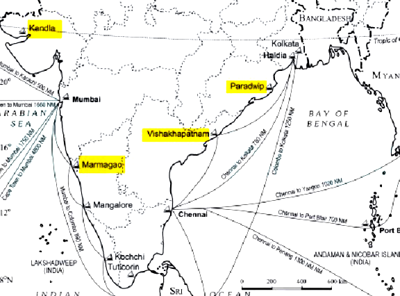
The correct answer is 3-2-4-1.
- Hence, option 1 is correct.
Key Points
- Kandla
- It is situated at the head of the Gulf of Kuchchh has been developed as a major port to cater to the needs of western and northwestern parts of the country and also to reduce the pressure at Mumbai port.
- Paradip
- It is situated in the Mahanadi delta, about 100 km from Cuttack.
- It has the deepest harbor especially suited to handle very large vessels.
- Vishakhapatnam
- It is situated in Andhra Pradesh is a land-locked harbor, connected to the sea by a channel cut through solid rock and sand.
- An outer harbor has been developed for handling iron-ore, petroleum, and general cargo.
- Andhra Pradesh and Telangana are the main hinterlands for this port.
- Marmagao
- It is situated at the entrance of the Zuari estuary, is a natural harbor in Goa.
Additional Information
- India has 13 major ports — 12 operated under the government and 1 is run by a corporation(Ennore Port). Deendayal (erstwhile Kandla), Mumbai, JNPT, Marmugao, New Mangalore, Cochin, Chennai, Kamarajar (earlier Ennore), V O Chidambarnar, Visakhapatnam, Paradip, and Kolkata (including Haldia).
- The Cabinet has given its nod to Major Ports Authority Bill that will replace a 1963 law governing the country’s 12 major ports and one port is run by a corporation.
- The proposed law is aimed at enhancing the overall efficiencies of the ports.
- Now ‘major ports’ will get to determine the tariffs for various port-related services as well as the terms for private developers who team up with them.
- Every port will now be governed by a Port Authority which will have powers to fix reference tariffs for various port services.
- The Bill also proposes the creation of an adjudicatory board at the apex level for review of port authority’s decisions.
- It will have the mandate to resolve the disputes between port authorities and the PPP operators.
-
Question 48
5 / -1
_______________ was launched to accelerate the efforts to achieve universal sanitation coverage and to put focus on sanitation.
Solution
The Swachh Bharat Mission (SBM) was launched to accelerate the efforts to achieve universal sanitation coverage and to put focus on sanitation.
Important PointsSwachh Bharat Mission
- Launched by the Prime Minister of India on 2nd October 2014.
- The Mission Coordinator for SBM is Secretary, Department of Drinking Water and Sanitation (DDWS), Ministry of Jalshakti with two Sub-Missions, the Swachh Bharat Mission (Gramin) and the Swachh Bharat Mission (Urban).
- The basic objective is to bring about an improvement in the general quality of life by ensuring cleanliness and sanitation.
Additional InformationSWASTH BHARAT
- The Pradhan Mantri Swasth Bharat Yojana was launched in February 2021.
- The main aim of the scheme is to address health issues in a holistic way.
-
Question 49
5 / -1
Which one of the following is non-renewable source of energy?
Solution
The correct answer is Thermal.
Key Points
- Renewable energy is also known as clean energy which is obtained from natural sources and can be replenished.
- Solar energy, wind energy, hydroelectric power, biomass energy, geothermal energy, and tidal energy are examples of renewable sources of energy.
- Energy is free in nature, some are infinitely available, called sustainably, and some are called non-renewable.
- It is our duty to ensure that sustainable and non-renewable technology is used properly.
- Non-renewable electricity is a finite resource that can inevitably run out over time.
- Non-renewable energy does not regenerate itself at a reasonable pace for sustainable economic extraction within meaningful human timeframes.
- Non-renewable energy is fossil fuel energy, such as coal, crude oil, natural gas, and uranium.
- Unlike renewable energy, non-renewable energy requires human interference to make it suitable for use.
- Fossil fuels are primarily fossil.
- Fossil fuels are thought to have been produced more than 300 million years ago when the planet was very different in its landscape.
- Types of Non-renewable resources:
- Fuels which are formed by remains of animals and plants
- Divided into further three categories: Natural Gas, Oil, and Coal
- Thermal Electricity uses Coal for heat production and converts that heat into electricity.
- Nuclear fuels: The use of fission-based nuclear energy requires naturally occurring radioactive material as a reactor.
- Uranium is the most natural fission fuel and is found in the soil at extremely low concentrations and extracted in 19 countries.
- Nuclear power generates approximately 6 % of the world's oil and 13-14% of the world's electricity.
Additional Information
- The difference between renewable and non-renewable sources of energy.
Renewable sources of energy | Non-renewable sources of energy |
Renewable sources of energy are the natural resources that get replenished from time to time. | Non-renewable sources of energy are obtained from the earth’s crust and once used they disappear. |
These resources do not cause any pollution. | These resources cause pollution. |
Solar energy and wind energy are examples of renewable sources of energy. | Fossil fuels and natural gas are examples of non-renewable sources of energy. |
-
Question 50
5 / -1
Identify the tribal groups that are native to the state of Himachal Pradesh, India:
Solution
Concept:
Tribal groups in India:
- In India, tribal people are referred to as "Adivasi."
- The term "Adivasi" refers to a diverse mix of ethnic and tribal groups.
- They are considered India's aboriginal inhabitants.
Explanation:
Gaddi Tribe:
- It is an Indo Aryan semi-pastoral ethnolinguistic tribe.
- This tribe mainly lives in the Indian state of Himachal Pradesh and Jammu Kashmir.
- The word Gaddi comes from the word "Garden", which is a native word in Himachal Pradesh that means "the home of the Gaddis".
- This scheduled tribe are mainly present in Bharmauri of Chamba district.
- They have their own defined culture, language, dress, food, marriage and devout celebration.
- According to a survey held in 2011, the Gaddi population in Himachal Pradesh is 1,78,130.
Thus, the tribal group that is native to the state of Himachal Pradesh, India is Gaddi Tribe.
Additional InformationSanthali Tribe:
- This is a Munda ethnic group native to India.
- According to its population, Santhal is the largest tribe in Jharkhand state.
- This tribe is also present in the state of Assa, Tripura, Bihar, Chhattisgarh, Orisha and West Bengal.
- They spoke the most widely spoken Munda language Santali
Gond Tribe:
- This tribe is the Dravidian ethnolinguistic group.
- This tribe present a scheduled tribe present in the state of Madhya Pradesh, Andhra Pradesh, Chhattisgarh, Odisha, Maharashtra, and Uttar Pradesh.
- They spoke the Gondi language.
Sahavia Tribe:
- This ethenic group is mainly present in the state of Madhya Pradesh and Rajasthan.
- This tribe is classified as a particularly vulnerable tribe.
- This tribe believes in Animism folk Hinduishms Gods and Goddesses.


 ×
×

 Sign in
 Profile
 Signout