-
Question 1
5 / -1
Which one of the following demographic parameters represents the population growth rate?
Solution
Growth of Population
- Growth of population is the change in the number of people living in a particular area between two points of time. Its rate is expressed in percentage. Natural change and net migration represents the population growth rate
- Population growth has two components namely:
- Natural growth - natural growth is analysed by assessing the crude birth and death rates.
- Induced growth-induced components are explained by the volume of inward and outward movement of people in any given area.
- The rate of natural increase is the difference between the birth rate and the death rate.
The rate of population growth is the rate of natural increase combined with the effects of migration. Thus, a high rate of natural increase can be offset by a large net out-migration, and a low rate of natural increase can be countered by a high level of net in-migration.
- The decadal and annual growth rates of population in India are both very high and steadily increasing over time.
- The annual growth rate of India’s population is 1.64 percent (2011).
-
Question 2
5 / -1
With reference to primary activities, the model of kholkhoz is associated with
Solution
The correct answer is Collective farming.
 Key Points
- Collective farming or the model of Kolkhoz was introduced in the erstwhile Soviet Union to improve upon the inefficiency of the previous methods of agriculture and to boost agricultural production for self-sufficiency.
- The basic principle behind Collective farming is based on social ownership of the means of production and collective labour.
- The model of kolkhoz is a cooperative agricultural enterprise operated on state-owned land by peasants from a number of households who belonged to the collective and who were paid as salaried employees on the basis of quality and quantity of labour contributed.
- Conceived as a voluntary union of peasants, the kolkhoz became the dominant form of agricultural enterprise as the result of a state program of expropriation of private holdings embarked on in 1929.
- The farmers used to pool in all their resources like land, livestock and labour.
- However, they were allowed to retain very small plots to grow crops in order to meet their daily requirements.
-
Question 3
5 / -1
Which country has the highest density of railway network?
Solution
The correct answer is the U.S.A.
Key Points
- The USA has the highest density of railway networks.
- The densest rail network is found in the highly industrialised and urbanised region of East-Central U.S.A. and adjoining Canada. Hence the correct answer is the U.S.A.
- In South America, the rail network is the densest in two regions - The Pampas of Argentina.
- The important railheads are London, Paris, Brussels, Milan, Berlin and Warsaw.
- Underground railways are important in London and Paris.
 Additional Information
- Railways are a mode of land transport for bulky goods and passengers over long distances.
- The railway gauges vary in different countries and are roughly classified as broad (more than 1.5 m), standard (1.44 m), metre gauge (1 m) and smaller gauges.
- The standard gauge is used in the U.K.
- Commuter trains are very popular in U.K., U.S.A, Japan and India.
- These carry millions of passengers daily to and fro in the city.
- There are about 13 lakh km of railways open for traffic in the world.
- Channel Tunnel, operated by Euro Tunnel Group, through England, connects London with Paris.
-
Question 4
5 / -1
Which of the following is not a measure for soil conservation?
Solution
The correct answer is Overdrawing of groundwater.
- Soil conservation is the prevention of loss of the topmost layer of the soil from erosion or prevention of reduced fertility caused by over usage, acidification, salinization, or other chemical soil contamination.
Key Points
- Some measures for soil conservation:
- Soil conservation practices are tools the farmer can use to prevent soil degradation and build organic matter.
- These practices include crop rotation, reduced tillage, mulching, cover cropping, and cross-slope farming. farmers to increase soil organic matter content, soil structure, and rooting depth.
- Strip cropping:
- Strip cropping is a method of farming that involves cultivating a field partitioned into long, narrow strips which are alternated in a crop rotation system.
- It is used when a slope is too steep or when there is no alternative method of preventing soil erosion.
- In strip cropping, different crops are grown on the same field in different strips or patches, usually alternatively.
- Shelterbelts:
- Shelterbelts are rows of trees, usually along fence lines.
- They are planted mainly to protect animals or crops from cold winds, but also to give shade in hot weather.
- In regions such as Canterbury where there is a lot of cultivated land, shelterbelts also reduce wind erosion.
- Terrace cultivation:
- Terrace cultivation is a method of growing crops on the sides of hills or mountains by planting on graduated terraces built into the slope.
- Though labour-intensive, the method has been employed effectively to maximize arable land area in variable terrains and to reduce soil erosion and water loss.
- Hence, only overdrawing of groundwater is not a method of prevention of soil erosion.
 Confusion Points
- Overdrawing of groundwater: It is a process ofo groundwater depletion that can cause soil erosion.
-
Question 5
5 / -1
Which organisation of UN published the Human Development Index Report?
Solution
The correct answer is United Nations Development Programme
Key Points
- UNDP works in about 170 countries and territories, helping to achieve the eradication of poverty and the reduction of inequalities and exclusion.
- As the UN’s development agency, UNDP plays a critical role in helping countries achieve Sustainable Development Goals.
- The HDI data regularly published by the United Nations Development Programme.
- The Human Development Index (HDI) is an index that measures key dimensions of human development.
- The components of the HDI is:
- Health
- Education
- Living of Standards
Additional Information
- The United Nations Environment Programme acts as a catalyst, advocate, educator, and facilitator to promote the wise use and sustainable development of the global environment.
- The United Nations Population Fund (UNFPA) is the lead UN agency for delivering a world where every pregnancy is wanted, every birth is safe, and every young person's potential is fulfilled.
- Out of 189 countries, India has ranked 131 on the Human Development Index 2020.
- The top nation on this list is Norway, Switzerland is in second place, and Ireland ranks third.
-
Question 6
5 / -1
Which region of India shifting cultivation is practiced?
Solution
correct answer is - North - Eastern region.
Additional Information
Concept:
Shifting Cultivation:
- Shifting cultivation is a form of agricultural practice in which farmers clear an area of land by slashing vegetation and burning forests for agricultural purposes.
- This practice is also known as slash-and-burn agriculture or slash-and-burn cultivation.
- Shifting cultivation is called by different names in different parts of India.
Salient features of shifting agriculture -
- Forest land is cleaned and ashes are added to the soil.
- it is also called Jhum agriculture.
- It is also known as fire-fallow cultivation.
- Cultivated spots/areas are usually small.
- Short periods of crop occupation alternate with long fallow periods.
- Field rotation is practised instead of crop rotation.
Explanation:
Shifting Cultivation is a type of subsistence farming in which farmer cultivates on a plot of land temporarily, and when he finds the land infertile to grow due to soil exhaustion, they move on to another plot.
It is largely practised in the north-eastern region of India, including Assam, Manipur, Mizoram, Nagaland, etc. This way of farming is also known as "Jhum Kheti".
-
Question 7
5 / -1
Which one of the following figures represents the working age group of the population?
Solution
The correct answer is 15 to 59 years.
Key Points
- The working population (i.e. women and men of the age group – 15 to 59).
- It is the total population in an area that is considered able and likely to work based on the number of people in a predetermined age range.
- The proportion of the working population engaged in these four sectors is a good indicator of the levels of economic development of a nation.
- In 2011, the Workforce Participation Rate at all Indian levels is 25.51% for females and 53.26% for males.
- While there is no rural-urban gap for males (53%).
- There is a considerable rural-urban gap for females (rural -30%, urban- 15.4%).
-
Question 8
5 / -1
Which one of the following activities is related to quaternary sector?
Solution
The correct answer is University teaching. Key Points
- The Quaternary sector of the economy Is based on the intellectual activities associated with government, culture, libraries, scientific research, education and information technology.
- It includes the person who relies on the people associated with the tertiary sector and the professional in charge of a particular department or section.
- Some examples of someone with a job associated with the quaternary sector of economic activity might be a store manager, a school principal, or a regional business supervisor.
- The top management of non-profit organizations, media, arts, culture, higher education, science and technology and government are all included in the quaternary economic sector.
Additional Information
- For much pharmaceutical industry, the quaternary sector is the most valuable because it creates future branded products from which the company will benefit.
- The quaternary sector includes other pure services, such as the entertainment industry.
- The quaternary sector is sometimes included in the tertiary sector since both are service sectors.
- It has been argued that intellectual services are sufficiently distinct to justify a separate sector and not be considered merely as a part of the tertiary sector.
- This sector evolves in well-developed countries and requires a highly educated workforce.
-
Question 9
5 / -1
Population pyramids are useful to
Solution
The correct answer is to Express the age-sex distribution of a population.
Key Points
- Population pyramids are important graphs for visualizing how populations are composed when looking at groups divided by age and sex.

- The population pyramid is a graphical representation of the age and sex composition of a specific population.
- Age structure represents the number of people of different age groups and is an important indicator of population composition.
- Demographers express the share of the dependent age groups using a metric called the 'age dependency ratio'. This measures the ratio between 'dependents' (the sum of young and old) to the working-age population that is aged between 15 to 64 years old.
- The large size of the population in the age group of 15- 59 indicates a large working population.
- A greater proportion of the population above 60 years represents an ‘ageing population’ or ‘the elderly population’ which requires more expenditure on health care facilities.
- A high proportion of the young population would mean that the region has a high birth rate and the population is youthful. This population is known as children and young adolescents who are under 15 years old.
-
Question 10
5 / -1
In which of the following regions has the oldest well-documented urban settlement found?
Solution
The correct answer is Mesopotamia.
Key Points
- In The urban settlement is a concentrated settlement that is part of an urban area.
- Mesopotamia is slightly older than Indus valley civilizations such as Harappa and Mohenjodaro, under present evidence.
- Mesopotamia regions have the oldest well-documented urban settlement found.
- Mesopotamia was the first to develop civilization, about 5500 years ago as opposed to around 5000 years ago for Egypt and the Indus valley.
- Civilization also appeared there at about the same time as it did in Mesopotamia.
-
Question 11
5 / -1
Consider the following statements:
1. The road highway density is the highest in North America.
2. The Trans-Continental Stuart Highway connects the countries of South America, Central America and the U.S.A.-Canada.
3. In Russia, a dense highway network is developed mainly in the industrialised region.
Which of the statements above is/are correct?
Solution
The correct answer is 1 and 3 only.
Key Points
- Highways are metalled roads connecting distant places.
- In North America, highway density is high, about 0.65 km per sq km. Hence statement 1 is correct.
- Every place is within 20 km distance from a highway.
- The Trans Canadian Highway links Vancouver in British Columbia(west coast) to St. John’s City in Newfoundland (east coast) and the Alaskan Highway links Edmonton (Canada) to Anchorage (Alaska).
- The Pan-American Highway, a large portion of which has been constructed, connects the countries of South America, Central America and U.S.A.-Canada.
- The Trans Continental Stuart Highway connects Darwin (north coast) and Melbourne via Tennant Creek and Alice Springs in Australia. Hence statement 2 is incorrect.
- Europe has a large number of vehicles and a well-developed highway network. But highways face a lot of competition from railways and waterways.
- In Russia, a dense highway network is developed in the industrialised region west of the Urals with Moscow as the hub. Hence statement 3 is correct.
- The important Moscow-Vladivostok Highway serves the region to the east.
- Due to the vast geographical area, highways in Russia are not as important as railways.
- In China, highways criss-cross the country connecting all major cities such as Tsungtso (near Vietnam boundary), Shanghai (central China), Guangzhou (south) and Beijing (north).
- A new highway links Chengdu with Lhasa in Tibet.
- In India, there are many highways linking the major towns and cities.
- For example, National Highway No. 7 (NH 7), connecting Varanasi with Kanya Kumari, is the longest in the country.
- The Golden Quadrilateral (GQ) or Super Expressway is underway to connect the four metropolitan cities — New Delhi, Mumbai, Bangalore, Chennai, Kolkata and Hyderabad.
- In Africa, a highway joins Algiers in the north to Conakry in Guinea. Similarly, Cairo is also connected to Cape Town.
-
Question 12
5 / -1
Select the correct statement about the types of rural settlement in India.
Solution
- There are various factors and conditions responsible for having different types of rural settlements in India.
- These include:
- physical features – nature of terrain, altitude, climate and availability of water
- cultural and ethnic factors – social structure, caste and religion
- security factors – defence against thefts and robberies.
Key Points
Rural settlements in India can broadly be put into four types:
Clustered Settlements:
- The clustered rural settlement is a compact or closely built-up area of houses.
- In this type of village, the general living area is distinct and separated from the surrounding farms, barns and pastures.
- The closely built-up area and its intervening streets present some recognisable pattern or geometric shape, such as rectangular, radial, linear, etc.
- Such settlements are generally found in fertile alluvial plains and in the northeastern states.
- Sometimes, people live in a compact village for security or defence reasons, such as in the Bundelkhand region of central India and in Nagaland.
- In Rajasthan, scarcity of water has necessitated compact settlement for maximum utilisation of available water resources.
Thus,
A clustered rural settlement is a compact or closely built-up area of houses: Correct
Clustered settlements present some recognisable patterns or geometric shapes: Correct
Uttar Pradesh has a compact settlement: Correct
Additional Information
Semi-Clustered Settlements:
- Semi-clustered or fragmented settlements may result from the tendency of clustering in a restricted area of dispersed settlement.
- More often such a pattern may also result from segregation or fragmentation of a large compact village.
- In this case, one or more sections of the village society choose or are forced to live a little away from the main cluster or village.
- In such cases, generally, the land-owning and dominant community occupies the central part of the main village, whereas people of lower strata of society and menial workers settle on the outer flanks of the village.
- Such settlements are widespread in the Gujarat plain and some parts of Rajasthan.
Hamleted Settlements:
- Sometimes a settlement is fragmented into several units physically separated from each other bearing a common name.
- These units are locally called panna, para, palli, nagla, dhani, etc. in various parts of the country.
- This segmentation of a large village is often motivated by social and ethnic factors.
- Such villages are more frequently found in the middle and lower Ganga plain, Chhattisgarh and lower valleys of the Himalayas.
Dispersed Settlements:
- The dispersed or isolated settlement pattern in India appears in the form of isolated huts or hamlets of few huts in remote jungles, or on small hills with farms or pasture on the slopes.
- Extreme dispersion of settlement is often caused by the extremely fragmented nature of the terrain and land resource base of habitable areas.
- Many areas of Meghalaya, Uttarakhand, Himachal Pradesh and Kerala have this type of settlement.
-
Question 13
5 / -1
What is unemployment due to mismatch in skills of the unemployed & skills needed for the available jobs?
Solution
The correct answer is Structural Unemployment.
Key Points
- Due to a mismatch in skills of the unemployed & skills needed for the available jobs Structural unemployment occurs.
- Structural unemployment is basically a type of long-term unemployment caused by shifts in the economy.
- Technological advances can cause some types of skilled labourers to become obsolete.
- And this is the most common reason for structural unemployment in the country.
Additional Information
- Cyclical unemployment is the component of overall unemployment that results directly from cycles of economic upturn and downturn.
- Unemployment typically rises during recessions and declines during economic expansions.
- Frictional unemployment is the result of voluntary employment transitions within an economy.
- Frictional unemployment naturally occurs, even in a growing, stable economy. Workers choosing to leave their jobs in search of new ones and workers entering the workforce for the first time constitute frictional unemployment.
- Disguised Unemployment
- Hidden unemployment does not impact the aggregate output of an economy.
- An example would be a small family farm with ten employees doing the same work.
- If three or four individuals were to discontinue working, the overall output of the farm would remain unchanged.
-
Question 14
5 / -1
The concept of Human Poverty Index (HPI) was introduced in the
Solution
The correct answer is the Human Development Report, 1997.
Key Points
- The Human Poverty Index (HPI) was an indication of the poverty of a community in a country, developed by the United Nations to complement the Human Development Index (HDI).
- It was first reported as part of the Human Development Report in 1997. Hence option 2 is Correct.
Additional Information
- It was considered to better reflect the extent of deprivation in deprived countries compared to the HDI.
- In 2010 it was supplanted by the UN's Multidimensional Poverty Index.
- The HPI concentrates on the deprivation in the three essential elements of human life already reflected in the HDI:
- longevity
- knowledge
- A decent standard of living.
- The HPI is derived separately for developing countries (HPI-1) and a group of select high-income OECD countries (HPI-2) to better reflect socio-economic differences and also the widely different measures of deprivation in the two groups.
-
Question 15
5 / -1
Choose the set of non-renewable resources
Solution
A resource is a source or supply from which a benefit is produced and that has some utility. Resources can broadly be classified upon their availability. They are classified into renewable and non-renewable resources.
Renewable resources
- Resources that are used by humans since human life exists.
- These resources are used by our ancestors for their daily purposes like lighting, shelter, transportation, cooking, A resource is a source or supply from which a benefit is produced and that has some utility. Resources can broadly be classified upon their availability. They are classified into renewable and non-renewable resources.
Renewable resourcesheating, protection from harm. - These are also known as non-conventional sources of energy.
- For example Soil, water bodies, sun, wind, tidal energy, geothermal, forest, mountains, wildlife, atmospheric resources.
- These can be used unlimited.
- They are environment friendly.
- The cost is low.
- They are pollution-free.
- They require high maintenance costs.
- They are sustainable resources.
- They cause no harm to life to exist on earth.
Non-Renewable resources
- The sources that cannot be replaced or reused once they are destroyed are called the Non-renewable resources.
- These are limited resources. so these are used limitedly.
- These are not environmentally friendly because the amount of carbon emission is high.
- The cost of these resources is high.
- They are not pollution-free.
- They require low maintenance cost.
- Coal, oil, nuclear energy, petroleum, natural gas, batteries, shale gas, phosphate are some examples.
Conclusion
- Natural gas, uranium, phosphates: All three are non-renewable resources.
- Uranium, natural gas, soil: The soil is a renewable resource. Therefore, all three are not non-renewable.
- Petroleum, uranium, geothermal energy: The geothermal is renewable. Therefore, all three are not non-renewable.
- Shale gas, uranium, soil: The soil is a renewable resource. Therefore, all three are not non-renewable.
-
Question 16
5 / -1
Which of the following has been identified as the problems of the iron and steel industry in India?
I. It requires a large amount of capital.
II. High cost of coking coal.
III. Increasing competition in the international market.
Solution
India's iron and steel industries are one of the country's most vital industries. In January 2019, India overtook Japan as the world's second-largest steel producer.
 Important Points
The problems faced by the iron and steel industry in India are as follows—
- Lack of high-quality coking coal
- Lack of capital
- Problem of acquiring land
- Lack of advanced machinery
- Lack of skilled laborers
- Problems of transportation
- Reduced demand in the national market
- Dumping of iron and steel products
- Lack of refractory bricks
Key Points
The major problems of the iron and steel industry in India are as follows:
- It necessitates a significant sum of money.
- Coking coal is expensive.
- The international market is becoming increasingly competitive.
Hence, statements I, II and III are problems of the iron and steel industry in India.
-
Question 17
5 / -1
Which one of the following is the main form of degradation in irrigated areas?
Solution
The correct answer is Salinisation of soils.
Key Points
- Salinization of soils is the increase of salt concentration in soil.
- It is caused by dissolved salts in the water supply.
- It occurs because of flooding of the irrigated land by seawater, seepage of seawater or brackish groundwater through the soil from below and poor irrigation practices.
- In India, arable land is turning saline mainly due to poor irrigation practices.
- Here, the excessive use of water for irrigation causes salt accumulation in soil.
- Also, the practice of waterlogging without adequate drainage has increased the problem of soil salinization.
-
Question 18
5 / -1
Which one of the following types of economic activities dominates in all rural settlements?
Solution
The correct answer is Primary.
Key Points
- Rural settlement:
- Rural settlement refers to a group of people who live together, the community of which is underdeveloped and not civilised.
- The important features of a rural community are:
- The village communities are smaller in area than the urban communities. As the village communities are small, the population is also low.
- The population shows homogeneity of language, culture, customs etc.
- Agriculture is the fundamental occupation of the rural people and forms the basis of the rural economy. Hence, option 1 is the correct answer.
- The rural people are in close contact with nature as most of their daily activities revolve around the natural environment.
- Slower means of communication.
- People are social and culture is simple.
- In rural society, social stratification is a traditional characteristic, based on caste. The rural society is divided into various strata on the basis of caste.
- In rural areas, mobility is rigid as all occupations are based on caste.
-
Question 19
5 / -1
Which one of the following South American nation, is a part of OPEC?
Solution
The correct answer is Venezuela.
Key Points
- The Organization of the Petroleum Exporting Countries is an intergovernmental organization or cartel of 13 countries.
- It was founded on 14 September 1960 in Baghdad by the first five members (Iran, Iraq, Kuwait, Saudi Arabia, and Venezuela).
- Since 1965 Its headquarters is in Vienna, Austria, although Austria is not an OPEC member state.
- The formation of OPEC marked a turning point toward national sovereignty over natural resources, and OPEC decisions have come to play a prominent role in the global oil market and international relations.
- The effect can be particularly strong when wars or civil disorders lead to extended interruptions in supply.
- The current OPEC members are the following - Algeria, Angola, Equatorial Guinea, Gabon, Iran, Iraq, Kuwait, Libya, Nigeria, the Republic of the Congo, Saudi Arabia, the United Arab Emirates and Venezuela.
- In 1949, Venezuela and Iran took the earliest steps in the direction of OPEC, by inviting Iraq, Kuwait and Saudi Arabia to improve communication among petroleum-exporting nations as the world recovered from World War II.
-
Question 20
5 / -1
Which one of the following forms of settlement is found around coastal areas?
Solution
Concept:
- There are various factors and conditions responsible for having different types of rural settlements in India.
- These include:
- physical features – nature of terrain, altitude, climate and availability of water
- cultural and ethnic factors – social structure, caste and religion
- security factors – defence against thefts and robberies.
Explanation:
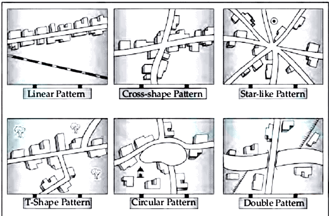
Settlement Alignment | Settlement Pattern |
Circular | - It is a type of circular pattern of settlement
- The settlements in which houses are constructed in a circular shape are known as Circular Patterns.
- Such kind of settlements is found around lakes, tanks, or a planned village.
|
Clustered | - It is clustered settlement pattern
- A clustered rural settlement is a rural settlement where a number of families live in close proximity to each other, with fields surrounding the collection of houses and farm buildings.
|
Star | - The settlements in which houses are constructed in a star shape is known as Star Pattern.
- Such kind of settlements is found around the points where several roads cross each other (making a star shape).
|
Uniform | - Uniform settlement occurs when a building foundation settles by the same amount over its entire footprint area, effectively lowering the structure in place.
- A related effect called tilt settlement occurs when the whole building tilts as a solid box.
|
| Linear | |
Thus, linear settlement is found around coastal areas.
-
Question 21
5 / -1
Which of the following industrial region is famous for IT industries in India?
Solution
An industrial complex would be an area intensively developed for industry. Several indices are used to identify the clustering of industries, important among them are:
- The number of industrial units
- The number of industrial workers.
- Quantum of power used for industrial purposes.
- Total industrial output.
- Value added by manufacturing, etc
India has several industrial regions like,
- Mumbai- Pune cluster,
- Bangalore-Tamil Nadu region,
- Hugli region,
- Ahmedabad-Baroda region,
- Chottanagpur industrial belt,
- Vishakhapatnam-Guntur belt,
- Gurgaon-Delhi-Meerut region,
- Kollam Thiruvanathapuram industrial cluster, etc.

Bangalore-Tamil Nadu Industrial Region:
- Spread in two states of Karnataka and Tamil Nadu, this region experienced the fastest industrial growth in the post-independence era.
- Bangalore is famous as the "Silicon Valley of India" because it is the IT industrial hub in our country.
- The establishment of public sector units in Banglore like Hindustan Aeronautics, Hindustan Machine Tools, Indian Telephone Industry and Bharat Electronics, etc. has further pushed up the growth of industries in the region
- This region is basically a cotton-growing tract and is dominated by the cotton-textile industry.
- it has large number of silk manufacturing units, sugar mills, leather industry, chemicals, rail wagons, diesel engines, radio, light engineering goods, rubber goods, medicines, aluminum, cement, glass, paper, cigarette, matchbox, and machine tools, etc.
- Coimbatore is known as Manchester of Tamilnadu because of its large-scale cotton textile industry.
Thus, option 2 is the correct answer.

- Chotanagpur Industrial Region: this region is located on the Chotanagpur plateau and extends over Jharkhand, Northern Orissa, and the Western part of West Bengal. this region is famous for the iron and steel industry.
- The Hugli Industrial Region: Located in West Bengal along the river Hoogly. It is famous for jute industries and Haldia petrochemical.
- Mumbai-Pune Industrial Region: This region extends from Thane to Pune and in adjoining districts of Nashik and Solapur. It is famous for cotton textile and chemical industries.
-
Question 22
5 / -1
"These are warm, dry winds descending the eastern slopes of the Rocky Mountains, primarily in winter and are often referred to as 'snow eaters'. This is the most likely description of
Solution
The correct answer is Chinook.
Key Points
- Chinook, warm, dry wind descending the eastern slopes of the Rocky Mountains, primarily in winter.
- Winds of the same kind occur in other parts of the world and the ones in the Alps are known generally as foehns.
- Chinook is a hot wind that blows in winter and therefore raises the temperature within a short time. This increase in temperature results in the melting of snow, and hence are popularly called 'snow eaters'.
- Melting the snow, they make pasture land available for grazing of animals. Besides, they hasten the growth of crops and fruits.
- Chinook winds develop when warm, moist air blows from the Pacific Ocean in the northwest region of North America toward the Rocky Mountain range.
- The air mass cools as it climbs the mountains, bringing rain or snow to the peaks.
- The air mass, now dry after releasing its moisture in the mountains, warms as it moves down the eastern side of the mountains.
- The air mass warms rapidly, eventually becoming warmer and drier than the original air mass coming from over the Pacific Ocean.
- When the winds suddenly change direction toward the west or southwest, the Chinook winds begin with rapidly increasing speeds.
Additional Information
- Foehn, warm and dry, gusty wind that periodically descends the leeward slopes of mountains and mountain ranges of Alps; particularly in Switzerland during spring.
- Mistral, cold and dry strong wind in southern France that blows down from the north along the lower Rhône River valley toward the Mediterranean Sea.
- It is strongest and most frequent in winter, and it sometimes causes considerable damage to crops.
- Harmattan, cool dry wind that blows from the northeast or east in the western Sahara and is strongest in late fall and winter (late November to mid-March).
- It usually carries large amounts of dust, which it transports hundreds of kilometres out over the Atlantic Ocean;
-
Question 23
5 / -1
Which of the following is a degradable pollutant ?
Solution
Important PointsPollution is the unwanted change in the physical, chemical or biological aspects of the environment which is harmful to living things directly or indirectly.
The harmful substances that cause pollution are known as pollutants.
Pollutants are broadly classified into:
Degradable – are the pollutants that can be broken down into simple harmless substances by natural processes, usually by microbial action. Example – Sewage, domestic wastes, agricultural wastes, paper, cloth etc.
Non-degradable – are those that cannot be broken down by natural processes and are toxic or harmful when they accumulate. Example – Plastics, insecticides, pesticides, mercury, steel, heavy metals, synthetic fibres etc.
Additional Information - Different types of pollution:
- Air pollution – It is caused by harmful gases like CO, CH4, CO2, nitrogen oxides released by burning of fuels, vehicular pollution or volcanic eruptions. These gases may produce smog, acid rain, greenhouse effect or directly cause respiratory illnesses.
- Water pollution – It is caused by various chemicals that are introduced into the water bodies by agricultural run-offs, sewage drainage, oil leakage from tankers or even direct garbage disposals. It affects aquatic life directly and other non-aquatic life forms that depend on aquatic life for food. This contaminates water, leading to various human diseases and also reduces amount of drinkable water available.
- Land pollution – It is caused by household or industrial wastes that is dumped in landfills. It may contain organic wastes, medical wastes or even hazardous industrial wastes.
- Noise pollution – It is caused by increased levels of noise in the environment due to factors like airplanes, ships, vehicles and heavy machinery. It induces stress-related problems in humans along with elevated blood pressure. It also disturbs the normal functioning of many animals by interfering with their communication or navigation systems.
-
Question 24
5 / -1
Migrations change the number, distribution and composition of the population in
Solution
Important Points The concept of migration and change in population:
- Population is a complex phenomena.
- The population's numbers, distribution and structure are continuously changing.
- This is the effect of the three cycles, including births, deaths and migrations.
- Population increase refers to the change in the number of a country/inhabitants territories over a given period of time, such as over the last ten years.
- It is possible to express such a change in two ways: in terms of actual numbers and in terms of percentage change per year.
- The movement of persons through regions and territories is migration.
Internal migration:
- Internal migration (within the country) or foreign (between countries) could be possible.
- Internal migration does not alter the population size, but alters the population distribution within the country.
External migration:
- External migration involves leaving one country to live in another.
- This type of migration is also an age-old phenomenon, but the most dramatic example of it took place in modern times.
Key PointsEffects of migration:
- In shifting the structure and distribution of the population, migration plays a very significant role.
- In India owing to the "push" element in rural areas, most migration has been from rural to urban areas.
- There are the unfavourable circumstances of rural poverty and unemployment and the 'pull' of the city in terms of improved prospects for jobs and better living conditions.
- A major determinant of demographic transition is migration.
- In terms of age and sex ratio, it modifies not just the population scale, but also the population composition of urban and rural populations.
- Rural-urban migration in India has led to a gradual growth in the proportion of the population in cities and towns.
Hence, both the area of departure and arrival will change the Migrations number, distribution and composition of the population.
-
Question 25
5 / -1
Which of the following is correct regarding Non-renewable resources?
Solution
The correct answer is They have limited stock.
Key Points
- Non-renewable resources:
- Non-renewable resources are those which have limited stock. Hence statement 1 is correct.
- Once the stocks are exhausted it may take thousands of years to be renewed or replenished.
- Since this period is much more than human life spans, such resources are considered non-renewable.
- Coal, petroleum, and natural gas are some examples of non-renewable resources.
- They are found deep inside the earth and are made by natural processes over many centuries.
Important Points
- Renewable resources:
- Renewable resources are those which get renewed or replenished quickly.
- Some of these are unlimited and are not affected by human activities, such as solar and wind energy.
- Yet careless use of certain renewable resources like water, soil, and forest can affect their stock.
-
Question 26
5 / -1
The Trans–Continental Stuart Highway runs between
Solution
The correct answer is Darwin and Melbourne.
Key Points
- Stuart Highway is one of Australia's major highways.
- It runs from Darwin, in the Northern Territory, via Tennant Creek and Alice Springs, to Port Augusta in South Australia, a distance of 2,720 km.
- The highway is named after Scottish explorer John Mc Dougall Stuart, who was the first European to cross Australia from south to north.
- The Royal Flying Doctor Service uses the highway as an emergency landing strip and sections of the highway are signed to that effect.
- These sections of highway have been specially selected and prepared for the landing of aircraft which only takes place after the piece of road has been closed by the police.
- The 492 km highway was built in under 90 days.
- In one week, 18 km was constructed, which was claimed to be a world record.
- North of Alice Springs the road was in comparatively good condition, with sections allowing speeds of up to 50 miles per hour (80 km/h).
Additional Information
- The Northern Territory section of the Stuart Highway starts from the edge of the Darwin central business district at Daly Street and continues as a dual-carriageway to the Arnhem Highway in Howard Springs.
- The highway continues 317 km south passing the Kakadu Highway to the Victoria Highway at Katherine.
- The Alaskan Highway links Edmonton to Anchorage.
- The Trans Canadian Highway run between Vancouver in British Columbia and St. John’s City in Newfoundland.
- Sichuan-Tibet Highway connects Chengdu of Sichuan to Lhasa of Tibet.
-
Question 27
5 / -1
Which one of the following is the correct definition of “Agenda 21”?
Solution
The correct answer is It is an action plan for the conservation of the global environment in the 21st century.
Key Points
- Agenda 21:
- Agenda 21 is an action plan of the United Nations (UN) related to sustainable development and was an outcome of the United Nations Conference on Environment and Development (UNCED) held in Rio de Janeiro, Brazil, in 1992.
- It is a comprehensive blueprint of action to be taken globally, nationally, and locally by organizations of the UN, governments, and major groups in every area in which humans directly affect the environment. The number 21 refers to an agenda for the 21st century.
Important Points
- Local Agenda 21:
- The implementation of Agenda 21 was intended to involve action at international, national, regional, and local levels.
- Some national and state governments have legislated or advised that local authorities take steps to implement the plan locally, as recommended in Chapter 28 of the document. Such programs are often known as ‘Local Agenda 21.
- Agenda 21 for culture:
- During the first World Public Meeting on Culture, held in Porto Alegre, Brazil in 2002, it came up with the idea to draw up document guidelines for local cultural policies, a document comparable to what Agenda 21 meant in 1992 for the environment.
- Agenda 21 for culture is the first document with a worldwide mission that advocates establishing the groundwork of an undertaking by cities and local governments for cultural development.
Additional Information
- There are 40 chapters in Agenda 21, divided into four main sections.
- It is grouped into 4 sections:-
- Section I - Social and Economic Dimensions
- Section II - Conservation and Management of Resources for Development
- Section III - Strengthening the Role of Major Groups
- Section IV - Means of Implementation
-
Question 28
5 / -1
Match the following List I and List II
| List I (Place) | List II (Industry) |
| A. Jamshedpur | I. Jute industry |
| B. Ahmedabad | II. Information technology industry |
| C. Bengaluru | III. Cotton textile industry |
| D. Kolkata | IV. Iron and steel industry |
Choose the correct answer from the codes given below.
Solution
Important Points | Place | Industry |
| A. Jamshedpur | - Before 1947, there was only one iron and steel plant in the country – Tata Iron and Steel Company Limited (TISCO).
- It was privately owned.
- After Independence, the government took the initiative and set up several iron and steel plants.
- TISCO was started in 1907 at Sakchi, near the confluence of the rivers Subarnarekha and Kharkai in Jharkhand.
- Later on, Sakchi was renamed Jamshedpur.
- Geographically, Jamshedpur is the most conveniently situated iron and steel center in the country.
|
| B. Ahmedabad | - It is located in Gujarat on the banks of the Sabarmati river.
- The first mill was established in 1859.
- It soon became the second-largest textile city of India, after Mumbai.
- Ahmedabad was therefore often referred to as the ‘Manchester of India’.
|
| C. Bengaluru | - Bengaluru is located on the Deccan Plateau from where it gets the name ‘Silicon Plateau’.
- The city is known for its mild climate throughout the year.
- Silicon Valley is a part of Santa Clara Valley, located next to the Rocky Mountains of North America.
|
| D. Kolkata | - The jute industry in India is 150 years old.
- There are about 70 jute mills in the country, of which about 60 are in West Bengal along both the banks of river Hooghly.
- By 1908 Calcutta was the world's largest jute producer
|
Hence, the correct matching is A-IV, B-III, C-II, D-I
-
Question 29
5 / -1
The phenomenon of ‘demographic dividend’ of a country relates to which of the following?
Solution
Option two is correct.
- The demographic dividend is an economic benefit resulting from the increase in the working age population.
- For a demographic dividend, a country must go through a demographic transition where it switches from a largely rural agrarian economy with high fertility and mortality rates to an urban industrial society characterized by low fertility and mortality rates.
- India is currently going through the phase of the demographic dividend.
Note: The term, “demographic dividend”, was first coined by
David Bloom.
-
Question 30
5 / -1
In which one of the following States are the major oil fields located?
Solution
The correct answer is Assam.
Key Points
- Petroleum raising states of India are Maharashtra (Mumbai High), Gujarat, Assam, Tamil Nadu, Arunachal Pradesh.
- Assam, Gujarat and Rajasthan, together account for more than 96% of oil from onshore fields.
- Assam is the oldest oil-producing state in India and has major oil fields of India located.
- Following are some of the important oilfields of Assam:
- The Digboi field (oldest field), The Naharkatiya field, The Moran-Hugrijan field, Rudrasagar, Galecki, Hugrijan, Angui and Lakwa fields.
- In Rajasthan, one of the largest oil discoveries was made in the Barmer district in 2004.
- In Bihar, there is only an oil refinery established at Barauni. It refines crude oil supplied from the Naharkatiya oil field of Assam.
- The Cauvery River basin has 21 oil wells located in it.
-
Question 31
5 / -1
Which one of the following is a water borne disease?
Solution
The correct answer is Cholera.
Key Points
- Waterborne disease
- Water-borne diseases are the ones caused by pathogenic microbes spread via contaminated water.
- Transmission of these pathogens occurs while using infected water for drinking, food preparation, and washing clothes, among others.
- Many developing countries do not have proper water treatment plants, especially in rural areas. In some places, the availability of water is so scarce that people have neither the time nor the money to afford the water purifiers or other water treatment mechanisms.
- The majority of water-borne diseases worldwide mainly affect children due to poor hygiene and weak immunity.
- Most of these diseases are life-threatening.
- The knowledge of the different types of water-borne diseases has come to the forefront with the advent of globalization over the past few decades.
- Several pathogenic microorganisms which were previously unknown, have become the focus of major research in this field.
- Few waterborne diseases: Diarrhea, Cholera, Typhoid, Amoebiasis, Hepatitis A.
Additional Information
- Smallpox
- Smallpox is an acute infectious disease that begins with a high fever, headache, and back pain and then proceeds to an eruption on the skin that leaves the face and limbs covered with cratered pockmarks, or pox.
- For centuries smallpox was one of the world’s most-dreaded plagues, killing as many as 30 percent of its victims, most of them children.
- Those who survived were permanently immune to a second infection, but they faced a lifetime of disfigurement and in some cases blindness.
- Smallpox was also one of the first diseases to be controlled by a vaccine, particularly following the great experiments of English physician Edward Jenner in 1796.
- In 1967 the World Health Organization (WHO) began a global vaccination program against smallpox, and in 1980 the disease was officially declared eradicated.
- Malaria
- Malaria is a serious relapsing infection in humans that is characterized by periodic attacks of chills and fever, anemia, splenomegaly (enlargement of the spleen), and often fatal complications.
- It is caused by one-celled parasites of the genus Plasmodium that are transmitted to humans by the bite of Anopheles mosquitoes.
- Malaria can occur in temperate regions, but it is most common in the tropics and subtropics.
- In many parts of sub-Saharan Africa, entire populations are infected more or less constantly.
- Malaria is also common in Central America, the northern half of South America, and in South and Southeast Asia.
- Tuberculosis
- Tuberculosis (TB) is an infectious disease that is caused by the tubercle bacillus, Mycobacterium tuberculosis.
- In most forms of the disease, the bacillus spreads slowly and widely in the lungs, causing the formation of hard nodules (tubercles) or large cheeselike masses that break down the respiratory tissues and form cavities in the lungs.
- Blood vessels also can be eroded by the advancing disease, causing the infected person to cough up bright red blood.
- The diagnosis of pulmonary tuberculosis depends on finding tubercle bacilli in the sputum, in the urine, in gastric washings, or in the cerebrospinal fluid.
-
Question 32
5 / -1
Which one of the following is the main reason for male migration in India?
Solution
The correct answer is Work and employment.
Key Points
- Work and employment is the main cause behind male migration.
- It constitutes 38% of total male migration.
- Education, Business and other reasons are also factors behind male migration but they contribute in less percentage.
Migration:
- Human migration is the movement of people from one place to another with the intention of settling, permanently or temporarily, at a new location.
- Types of Migration:
- Economic migration - people moving to find work or follow a particular career or business.
- Social migration - people moving for a better quality of life or to be closer to family or friends.
- Political migration - people moving to escape political persecution or war.
- Environmental causes of migration include natural disasters such as flooding.
-
Question 33
5 / -1
Which one of the following south Indian states has the highest groundwater utilisation (in per cent) of its total ground water potential?
Solution
The correct answer is Tamil Nadu.
Key Points
- As per the Central Ground Water Board, India is the largest user of groundwater in the world.
- Here, the extraction is about 253 billion cubic meters (bcm) groundwater per year.
- It is about 25% of the global groundwater extraction.
- India has about 1123 billion m3 of water resources available, out of which 433 bcm is groundwater.
- Out of total groundwater available, 90% of it is used for irrigation purposes.
- As per the Central Ground Water Board, the states with large groundwater resources for irrigation are Assam, Bihar, Madhya Pradesh, Maharashtra and Tamil Nadu.
- Each of these states has more than 20 bcm/year groundwater resources for irrigation.
- In Northern India, Haryana, Punjab exploit more than 85% of the available groundwater for irrigation.
- In the south, Tamil Nadu has high-level extraction of groundwater. Here, groundwater is primarily used to irrigate the rice crop.
-
Question 34
5 / -1
Which one of the following minerals is known as brown diamond?
Solution
The correct answer is Lignite.
Key Points
- Lignite is known as Brown Diamond.
- Lignite is also known as brown coal, lignite is lower-grade coal and contains about 40 to 55% carbon.
- It represents the intermediate stage in the alteration of woody matter into coal. Its colour varies from dark to black-brown.
- Its moisture content is high (over 35%) so that it gives out much smoke but little heat.
- It is found in Palna of Rajasthan, Neyveli of Tamil Nadu, Lakhimpur of Assam, and Karewa of Jammu and Kashmir.
- Lignite is known as ‘brown diamond’ since it is coal in brown colour.
- Lignite in Tamil Nadu
- 90% of the reserves.
- 57% of the production.
- Neyveli Lignite fields of Cuddalore district.
- These are the largest deposits of lignite in southeast Asia.
- Neyveli mines suffer from the artesian structure [mining goes deep and deep].
- Mining in Lignite coalfields is risky due to the SPONTANEOUS COMBUSTION of lignite.
- Lignite in Gujarat and Rajasthan
- Kachchh district and Bharuch district; poor quality.
- Rajasthan: Palana in Bikaner district.
- The 250 MW thermal plant at Bikaner wholly depends upon lignite as the basic fuel.
-
Question 35
5 / -1
Which is the project to clean the river Ganga started by the Government of India?
Solution
The correct answer is Namami Gange.
Key Points
- Namami Gange is the project to clean the river Ganga launched by the Government of India.
- The project integrates the efforts to clean and protect the Ganga River in a comprehensive manner.
- It was approved as a ‘Flagship Programme’ by the Union Government in June 2014.
- The main objectives of the Namami Gange project are:
- Effective abatement of pollution.
- Conservation and rejuvenation of National River Ganga.
- It is being implemented by the National Mission for Clean Ganga (NMCG), and its State Program Management Groups.
- The Ganga serves as one of India's holiest rivers whose cultural and spiritual significance transcends the boundaries of the basin.
- The Centre funds 100% of the Namami Gange project.
Additional Information
- Polavaram Project is an under-construction multi-purpose irrigation project in Andhra Pradesh.
- The Kalpasar Project is a water resources project by way of building an Over Sea dam across the Gulf of Khambhat.
- It is also called the Gulf of Khambhat Development Project.
- Ganga Manthan was a national conference conducted to discuss issues and possible solutions for cleaning the river.
-
Question 36
5 / -1
In 1992, more than 100 heads of state met in Rio de Janeiro, Brazil, for the first International Earth Summit. This summit was also called ________.
Solution
Important Points
- The United Nations Conference on Environment and Development (UNCED), also known as the Rio de Janeiro Earth Summit.
- This conference was held in Rio de Janeiro from June 3 to June 14 1992.
- The assembled leaders signed the Declaration on Global Climatic Change and Biological Diversity.
- The Rio Summit produced conventions dealing with climate change, biodiversity, forestry, and recommended a list of development practices called ‘Agenda 21’.
- It aims at achieving global sustainable development and to combat environmental damage, poverty, disease through global co-operation on common interests, mutual needs and shared responsibilities.
- The Forest Principles is a 1992 document produced at the United Nations Conference on Environment and Development .
- It is a non-legally binding document that makes several recommendations for conservation and sustainable development forestry.
Hence,In 1992, more than 100 heads of state met in Rio de Janeiro, Brazil, for the first International Earth Summit. This summit was also called United Nations Conference on Environment and Development.
-
Question 37
5 / -1
In which of the following trade blocs, is India an associate member?
Solution
The correct answer is ASEAN.
Key Points
- In August 2009, India signed a Free Trade Agreement (FTA) with the ASEAN members in Thailand.
- Under the ASEAN-India FTA, ASEAN member countries and India will lift import tariffs on more than 80 per cent of traded products between 2013 and 2016, according to a release by the Ministry of Commerce and Industry.
- India became a sectoral dialogue partner of ASEAN in 1992.
- Mutual interest led ASEAN to invite India to become its full dialogue partner during the fifth ASEAN Summit in Bangkok in 1995.
- India also became a member of the ASEAN Regional Forum (ARF) in 1996.
- India and ASEAN have been holding summit-level meetings on an annual basis since 2002.
- ASEAN officially the Association of Southeast Asian Nations, is an economic union comprising 10 member states in Southeast Asia, which promotes intergovernmental cooperation and facilitates economic, political, security, military, educational, and sociocultural integration between its members and other countries in Asia.
- ASEAN's primary objective was to accelerate economic growth and through that social progress and cultural development.
- A secondary objective was to promote regional peace and stability based on the rule of law and the principle of the United Nations charter.
Additional Information
- A trading bloc is a formal agreement between two or more regional countries that remove trade barriers between the countries in the agreement while keeping trade barriers for other countries.
- Types of Trading Blocs -
- Free Trade Area - Two or more countries form a Free Trade Area in which trade barriers between the countries are abolished but each country maintains its own tariffs against non-member countries.
- Customs Union - A Customs Union is like a free trade area except that member countries maintain a common tariff against non-member countries.
- Common Market - A Common Market is like a customs union but there is a free flow of factors of productions between the countries.
- Economic Union - An Economic Union has the same benefits as a common market but there is a common tax system and employs the same currency.
- In January 2010, Singapore, Malaysia and Thailand accepted the FTA on goods.
- The other seven ASEAN countries are expected to operationalise the FTA by August 2010.
- As of 2010, the Association of Southeast Asian Nations (ASEAN) has 10 member states, one candidate member state, and one observer state.
- ASEAN was founded on 8 August 1967 with five members: Indonesia, Malaysia, the Philippines, Singapore, and Thailand. It is headquartered in Jakarta.
-
Question 38
5 / -1
Which one pair of the following places is linked by Channel Tunnel?
Solution
The correct answer is Paris – London.
Key Points
- The idea of a tunnel under the Channel was first proposed in 1802 but construction wasn't started until 1988.
- It was completed in 1993, and Eurostar services started in November 1994.
- The Channel Tunnel is 31.5 miles long or 50.45 km.
- 23.5 miles (37.9 km) of the Channel Tunnel is under the English Channel, making it the world's longest undersea tunnel.
- At its deepest, the tunnel is 75 metres (246 feet) below sea level.
- The Channel Tunnel is made of three separate tunnels running parallel to each other.
- One train tunnel running south (the UK to France), one train tunnel running north (France to the UK) and one service tunnel.
- The Channel Tunnel is an undersea tunnel linking southern England and northern France.
- Foot passengers can travel with Eurostar, between our UK stations and our stations on the continent
- Ashford International train station connects travellers with European cities such as Paris, Brussels and Lille via Eurostar services, as well as London and South East England via Southeastern high-speed.
Additional Information
- Channel is operated by the company Get a link, which also runs a railway shuttle between Folkestone and Calais.
- The Channel Tunnel is actually comprised of three tunnels - two rail tunnels, used for freight and passenger trains, and a service tunnel.
- Eurostar is a totally separate company and is Getlink’s biggest customer, running high-speed passenger services through the Channel.
-
Question 39
5 / -1
Which one of the following is a result of rapid industrialisation and urbanization?
Solution
The correct answer is Rural depopulation.
Important Points
- Industrialization occurs when an industry is introduced on a large scale to a region or country — for example, when an economy goes from being based on agriculture to being based on production and other industries.
- This period hence referred to the Industrial Revolution.
- Urbanization relates to the increasing number of people that live in urban areas.
- Urbanization is not solely a modern phenomenon, but a rapid and historic transformation of human social roots on a global scale, whereby predominantly rural culture is being quickly replaced by predominantly urban culture.
Key Points
- Rural depopulation processes affect regions where the rural exodus surpasses natural growth, reducing the total number of inhabitants to a critical level and causing aging of demographic compositions.
- Nevertheless, depopulation may also be caused by displacement because of large infrastructure investments.
-
Question 40
5 / -1
Which one of the following crops is not cultivated under dryland farming?
Solution
The correct answer is Sugarcane.
Key Points
- Dryland farming: It is the technique of cultivation of crops in areas receiving rainfall above 750 mm.
- Here, a dry spell during crop duration occurs, but crop failures are less frequent.
- Major dry farming crops are:
- Millets such as jawar, bajra, ragi.
- Oilseeds like mustard, rapeseed, and
- Pulse crops like pigeon pea, gram and lentil.
- Sugarcane is a water-intensive crop, so it can not be produced in dryland farming. Hence, option 4 is correct.
Additional Information
- Climatic features for the growth of Sugarcane:
- A long frost-free growing season.
- Hot and moist climate.
- Average annual rainfall: Between 100 cm and 150 cm.
- Deep, well-drained, rich loamy soil is ideal for its growth.
- Bright sunshine after the rainfall increases the juice content in sugar cane.
-
Question 41
5 / -1
Which among the following terms of utmost significance in the dynamics of resource management was coined in the ‘Brundtland Commission Report’?
Solution

Brundtland Commission Report:
- To reunite countries to work and pursue sustainable development together, the UN decided to establish the Brundtland Commission.
- Formerly known as the World Life Issues on Environment and Development (WCED), the mission of the Brundtland Commission is to unite countries to pursue sustainable development together.
- Gro Harlem Brundtland was the former Prime Minister of Norway and was chosen due to her strong background in the sciences and public health.
- The Brundtland Commission’s characterization of ‘sustainable development' is a development that satisfies the needs of the present without compromising the ability of future generations to meet their own needs.
Thus, the term sustainable development was coined in the ‘Brundtland Commission Report’.

Polluter-Pays Principle:
- The 'polluter pays' principle is the commonly accepted practise that those who produce pollution should bear the costs of managing it to prevent damage to human health or the environment.
- It is a fundamental principle in US environmental law.
Inclusive Growth:
- Inclusive growth means economic growth that creates employment opportunities and helps in reducing poverty.
- It means having access to essential services in health and education by the poor.
- It includes providing equality of opportunity, empowering people through education and skill development.
Carrying Capacity:
- The carrying capacity of an environment is the maximum population size of a biological species that can be sustained by that specific environment, given the food, habitat, water, and other resources available.
- Neo-Malthusians popularised the use of the words to describe the number of people the Earth can support in the 1950s.
-
Question 42
5 / -1
Land which is left without cultivation for one or less than one agricultural year is known as:
Solution
The correct answer is current fallow.
Key Points Current fallow: This represents the cropped area that is kept fallow during the current year. If a seeding area is not cropped against the same year, it may be treated as current fallow.
Additional Information
- Culturable waste land Includes land available for cultivation, but not cultivated during the current year and the last five years or more in succession for one reason or other.
- Such lands may be either fallow or covered with shrubs, which are not put to any use.
- They may be assessed or unassessed and may lie in isolated blocks or within cultivated holdings.
- Land once cultivated but not cultivated for five years in succession are also included in this category at the end of the five years.
- Net area sown: Represents the total area sown with crops and orchards. Area sown more than once in the same year is counted only once.
-
Question 43
5 / -1
Which of the following is an important determinant of population change?
Solution
The correct answer is Migration.
Key Points
- Migration is an important determinant of population change.
- Migration is the movement of people across different states and regions.
- When people migrate within the boundaries of the country, it is called internal migration.
- International migration refers to the migration of people between countries.
- Migration is an important determinant of population change as it not only changes the size of the population but also affects the population composition of urban and rural areas.
- In India, the rural-urban migration has resulted in a steady increase in the percentage of the population in cities and towns.
-
Question 44
5 / -1
Which one of the following is the largest linguistic group of India?
Solution
The correct answer is Indo-Aryan.
Key Points
- As per the Linguistic survey report of the 2011 census,
| Language Family | Number of Languages | Percentage of the total population |
| 1. Indo-European |
| 1. a. Indo-Aryan | 21 | 78.05 |
| 1. b. Iranian | 1 | 0.00 |
| 1. c. Germanic | 1 | 0.02 |
| 2. Dravidian | 17 | 19.64 |
| 3. Austro - Asiatic | 14 | 1.11 |
| 4. Tibeto - Burmese | 66 | 1.01 |
| 5. Semito - Hamitic | 1 | 0.00 |
- Hence. option 3 is correct.
-
Question 45
5 / -1
The highest proportion of the total water used in the country is in which one of the following sectors?
Solution
The correct answer is Irrigation.
Key Points
- India accounts for about 4% of the world’s water resources.
- The total water available from rainfall in the country in a year is about 4,000 cubic km.
- In India, the river basins are estimated to be 1,869 cubic km which fulfil India’s water demand mostly for irrigational needs.
- Agriculture accounts for most of the surface and groundwater utilisation.
- In agriculture, water is mainly used for irrigation.
- It accounts for 89% of the surface water and 92% of the groundwater utilisation.
- While the share of the industrial sector is 2% of the surface water utilisation and 5% of the ground-water and the share of the domestic sector is 9% in surface water utilisation.
- In Punjab, Haryana and Western Uttar Pradesh, more than 85% of their net sown area is under irrigation.
-
Question 46
5 / -1
At which one of the following places was the first atomic power station started?
Solution
The correct answer is Tarapur.
Key Points
- In India, nuclear power is the fifth-largest source of generating electricity after coal, gas, wind power and hydroelectricity.
- At present, India has 23 operational nuclear reactors with an installed capacity of 6,885 MW in 7 nuclear power plants.
- The Tarapur Atomic Power Station (TAPS) in the Thane District of Maharashtra is India's first atomic power project.
- Reactor type: Boiling water reactors (BWRs).
- Commission date: 28 Oct 1969.
Important Points
- Kalpakkam Atomic Power Station is located at Kalpakkam in Chennai.
- Reactor type: Fast breeder reactors (FBRs).
- Commission date: 27 January 1984.
- Narora Atomic Power Station (NAPS) is located in Narora, U.P.
- Reactor type: Pressuiresed Heavy water (PHWRs).
- Commission date: 1 January 1991.
- The Rawatbhata Atomic Power Project (RAPP) or Rana Pratap Sagar Atomic Power Project is located in Rawatbhata, Rajasthan.
- Reactor type: Pressurised heavy water reactor (PHWR).
- Commission date: 16 December 1973.
Additional Information - Asia's first nuclear reactor is the Apsara Research Reactor situated in Mumbai.
-
Question 47
5 / -1
Choose the correct sequence of 5Rs of waste management
Solution
Concept :
Solid waste can be categorised into
- Biodegradable waste(that can be degraded naturally eg. Organic waste such as vegetable peels)
- Non-biodegradable waste(that cannot be degraded by natural process eg. Plastic, metal cans etc)
- Solid waste management is one important challenge of urban bodies
- It can be achieved by following the 5Rs of waste management.
Explanation:
- Refuse: refuse the usage of non-biodegradable products as much as possible
- Reduce: If users cannot be refused completely, reduce the amount of consumption
- Reuse: As much as possible try to use a substance for as long as and in as many ways as possible
- Repurpose: For every item that can't be refused, reduced, or reused, try repurposing it eg. Try using wasted printer paper for scrap paper, cardboard boxes for storing supplies, binder clips to hold power cords
- Recycle: Recycling is the most environmentally friendly waste disposal method, which means to collect waste and produce a new product from it eg Bitumen is a recycled product made out of waste plastics that can be used for road construction
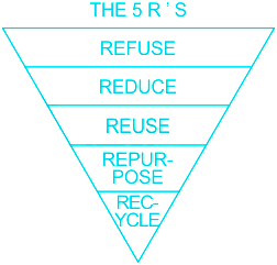
∴ The correct sequence is refuse, reduce, reuse, repurpose and recycle
-
Question 48
5 / -1
Which one of the following continents has the maximum flow of global trade?
Solution
The correct answer is Europe.
Key Points
- Europe has a maximum flow of Global trade.
- Global trade has been an ancient feature since early civilizations such as Indus Valley Civilization, Mesopotamia, etc.
- In modern times technological advancements along with the industrial revolution led to a rapid boom in the volume of global trade.
- Global trade, also known as international trade, is simply the import and export of goods and services across international boundaries.
- Global trade can create economic wealth on a global scale as each country maximizes its revenue and growth by focusing on what it does best and saving money on imports that would be more costly for it to produce domestically.
- Global trade can also reduce international conflict and war.
- Global trade creates long-term mutually beneficial relationships.
- The World Trade Organization (WTO) is a multilateral organization headquartered in Geneva, Switzerland.
- It came into existence on January 1, 1995, as a successor to the General Agreement on Tariffs and Trade (GATT).
- The organization functions as a central body that facilitates global trade.
-
Question 49
5 / -1
Which one of the following types describes water as a resource?
Solution
The correct answer is Cyclic resource.
Key Point
- Biotic resources are resources that are derived from the biosphere like living things and from forests and the materials derived from them.
- Example: coal gas, petroleum, etc
- Abiotic resources are resources that are non-living.
- These resources occur naturally within the environment and aren't created or produced by humans.
- E.g: air, water, sunlight, soil, minerals etc.
- A resource that can be formed, again and again, is known as a cyclic resource.
- Water is a cyclic resource as water from the sea, the river and ocean etc. evaporates and forms clouds.
- When the rain occurs water from these clouds comes on earth and flows down into seas, lakes, oceans etc.
- In this way, the water gets formed again and again and is called a cyclic resource.
- Non-renewable Resources: These are the resources that are present infinite quantities and cannot be renewed along with their exploitation.
- Examples: coal, minerals, fossil fuels etc.
-
Question 50
5 / -1
Which is not a factor of industrial location?
Solution
The correct answer is Population Density.
Key Points
- Industrial locations are influenced by the availability of various factors.
- These factors can be classified into two categories:
Geographical Factors:
- Availability of raw material, Storage and warehousing, Characteristics of land and soil, Precipitation and water resources, Climate etc.
Non-geographical Factors:
- Power, Labour, Marketing feasibility, Capital investment, Availability of loans, Government policies/regulations etc.
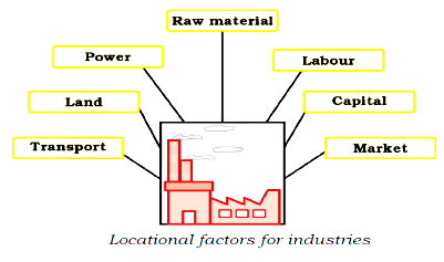
- Population density is not a factor to be considered when choosing an industrial location. Hence, option 2 is correct.


 ×
×

 Sign in
 Profile
 Signout