-
Question 1
5 / -1
Which one is a primary activity?
Solution
The correct answer is Mining.
 Key Points
- The primary activity includes those occupations which are closely related to man’s natural environment.
- The most important feature of the primary sector is that it forms the base for all other activities.
- These economic functions deliver the raw material for other industries, which further refine and develop these materials into products to sell to customers.
- Some important examples of primary activities are Gathering, hunting, fishing, lumbering, animal rearing, farming, and mining.
- Animal rearing or dairy is a primary activity. In this activity, farmers are dependent on the biological process of the animals, and the availability of fodder, etc. The product, milk, is also natural.
 Additional Information
- Secondary activities are those activities that involve the manufacturing of finished goods by processing the raw materials that are found in nature.
- It is known as the manufacturing sector.
- Some examples of the secondary sector include metalworking and smelting, automobile production, textile production, chemical and engineering industries, aerospace manufacturing, energy utilities, engineering, breweries and bottlers, construction, and shipbuilding.
- The Tertiary sector is known as the service sector.
- This sector provides useful services to primary and secondary sectors for this functioning of their working.
- Services related to banking, insurance, trade, and communication come in this sector.
-
Question 2
5 / -1
Kharif crops are harvested in ________.
Solution
The correct answer is September-October.
Key Points
- Kharif crops are sown in the rainy season.
- They are usually sown with the beginning of the first rains in July till August, during the southwest monsoon season.
- These crops are harvested in September and October.
- Important Kharif crops are rice, maize, millets, pulses and fibre crops like cotton and jute.
- These crops are dependent on the quality of rainwater as well as its timing.
- Rice is the most important Kharif crop in India.
Thus, we can say that kharif crops arre harvested in September- October.
-
Question 3
5 / -1
_________ power plant is the plant which uses the non-conventional source of energy.
Solution
The wind power plant is the plant that uses the non-conventional source of energy.
In general, power plants can be divided into two categories - conventional and non-conventional power plants.
Conventional power plants:
- Fossil fuel power plants: Generates electric power by burning fossil fuels like coal, natural gas or diesel.
- Nuclear power plants: The Controlled nuclear reaction is maintained to generate electricity.
- Hydroelectric power plants: Electricity is produced by building dams on suitable rivers.
Non-conventional power plants:
- Wind power plants: The kinetic energy of wind is used to create power.
- Solar power plants: Generates power by collecting solar radiation
- Geothermal power plants: Uses the natural heat found in the deep levels of the earth to generate electricity.
- Biomass power plants: Natural organic matter is burnt to produce electricity.
-
Question 4
5 / -1
In which of the following groups of countries of the world, HYVs of wheat and rice were developed?
Solution
The correct answer is Mexico and Phillippines.
Key Points
- High Yield Variety
- The draught of 1966 also made it inevitable to develop a new technique of agriculture to increase production and make India self-sufficient in food grains.
- The HYVs (High Yielding Varieties) of seeds for wheat (from Mexico) and rice (from the Philippines) were introduced in 1966-67.
- Coupled with the use of chemical fertilization and better irrigation, these techniques were employed on a full scale in Punjab & Haryana.
- This initiative was known as Green Revolution (GR) because of which surprising levels of productivity were achieved.
Additional Information
- The Green Revolution
- It was an endeavor initiated by Norman Borlaug in the 1960s.
- He is known as the Father of the Green Revolution in the world.
- It led to him winning the Nobel Peace Prize in 1970 for his work in developing High Yielding Varieties (HYVs) of wheat.
- In India, the Green Revolution was mainly led by M.S. Swaminathan.
- The Green Revolution resulted in a great increase in the production of food grains (especially wheat and rice) due to the introduction into developing countries of new, high-yielding variety seeds, beginning in the mid-20th century.
- Its early dramatic successes were in Mexico and the Indian subcontinent.
- The Green Revolution, spreading over the period from 1967-68 to 1977-78, changed India’s status from a food-deficient country to one of the world's leading agricultural nations.
-
Question 5
5 / -1
Viticulture is known as the cultivation and harvesting of_______?
Solution
The correct answer is Grapes.
- Viticulture is known as the cultivation and harvesting of Grapes.
Key Points
- Viticulture is a type of cultivation, largely a speciality of Tropical areas.
- The planting and harvesting of Grapes is the viticulture or wine growing.
- It is the branch of horticulture science.
- Although the native territory of Vitis Vinifera the common grape wine from Western Europe to the Persian shores of the Caspian Sea.
- The wine has shown a high level of adaptability to new conditions, so viticulture can be found on all continents except Antarctica.
- The vast majority of wine-producing regions of the world are located in every hemisphere between the temperate latitude of 30°and 50°.
- Floriculture or flower farming is the study of marketing and growing foliage plants and flowers.
-
Question 6
5 / -1
If the age distribution (percent individuals of a given age or age group) is plotted for population, the resulting structure is called:
Solution
Concept:
Population
- Any collection of organisms of the same species that inhabit a given area and act as part of a biotic community is referred to as a population.
Growth of Population
- The growth of population is the change in the number of people living in a particular area between two points of time.
- Its rate is expressed in percentages.
- Population growth has two components namely; natural and induced.
- While the natural growth is analysed by assessing the curve birth and death rates, the induced components are explained by the volume of inward and outward movement of people in any given area.
Explanation:
Age pyramid
- A population pyramid is used to show the age-sex structure of the population.
- The shape of the population pyramid reflects the characteristics of the population..
- The percentage of people of a certain age or age group is known as age distribution.
- Individuals of various ages make up a population at any particular time.
- When the population's age distribution is plotted, the resulting structure is known as an age pyramid.
If the age distribution (per cent individuals of a given age or age group) is plotted for the population, the resulting structure is called: Age pyramid.
Additional InformationSurvivorship curve
- The number of people in a population who can be predicted to live to a certain age is represented graphically by the survivorship curve.
Life table
- A population's life and death are recorded in a life table.
- It summarises the probability of organisms in a population living, dying, or reproducing at various phases of their life.
Logistic model
- As a population's size approaches a maximum is imposed by limited resources in the environment, known as the carrying capacity.
- It happens in logistic growth.
- The pace of per capita increase slows.
-
Question 7
5 / -1
Which of the following is a conventional source of energy?
Solution
The correct answer is Thermal power.
Key Points
- The energy of a body is its capacity to do work. It is measured the total amount of work that the body can do.
- Conventional energy sources are:
- Fossil fuel energy
- Hydraulic energy
- Nuclear energy
- Fossil fuel energy:
- Coal, petroleum, and natural gas are called Fossil fuel as these are formed by the decomposition of the remains of dead plants and animals buried under the earth for a long time.
- These are non-renewable sources of energy, which, if exhausted, can not be replenished in a short time.
- Their reserves are limited and are considered very precious.
- These should be used with care and caution to let them last long.
- These are also contributing to the global environmental pollution.
 Important Points
- Non-Conventional Energy sources are:
(a) Solar energy
(b) Wind energy
(c) Tidal energy
(d) Geothermal energy
-
Question 8
5 / -1
Producing sugarcane is a ______ activity while making gur is a ______ activity
Solution
The three-sector model in economics divides economies into three sectors of activity: extraction of raw materials (primary), manufacturing (secondary), and service industries which exist to facilitate the transport, distribution, and sale of goods produced in the secondary sector (tertiary).
Key Points
Primary activity:
- Primary activity includes those occupations which are closely related to man's natural environment.
- Gathering, hunting, fishing, lumbering, animal rearing, farming, and mining are some of the important examples of primary activities.
- Primary activities are directly dependent on the environment as these refer to the utilization of the earth's resources such as land, water, vegetation, building materials, and minerals.
Secondary activity:
- A secondary activity is an activity performed by a unit in addition to its principal activity.
- The result of a secondary activity is called secondary production.
- The secondary sector covers activities in which natural products are changed into other forms through ways of manufacturing that we associate with industrial activity.
- It is the next step after the primary activity.
Producing sugarcane in the field is an example of primary activity, Making gur or sugar using raw sugarcane is a processor of transformation of primary product. So, it is a secondary activity.
-
Question 9
5 / -1
In which of the following state the security factor is a reason for compact villages?
Solution
The correct answer is Nagaland.
Key Points
Clustered Settlements -
- The clustered rural settlement is a compact or closely built up area of houses.
- In this type of village, the general living area is distinct and separated from the surrounding farms, barns and pastures.
- The closely built-up area and its intervening streets present some recognisable pattern or geometric shape, such as rectangular, radial, linear, etc.
- Such settlements are generally found in fertile alluvial plains and in the northeastern states.
- Sometimes, people live in a compact village for security or defence reasons, such as in the Bundelkhand region of central India and in Nagaland. Hence the correct answer is option 1.
- In Rajasthan, scarcity of water has necessitated compact settlement for maximum utilisation of available water resources.
-
Question 10
5 / -1
What is Internet?
Solution
The correct answer is option 2.
Key PointsInternet
- Internet is one of the most effective and advanced personal communication system.
- Uses:
- It enables the users to establish direct contact e-mail to get access to the world of knowledge and information.
- It is also used for e-commerce and carrying out money transactions.
- The internet is like a huge central warehouse of data, with detailed information on various items.
- It enables us with the basic facilities of direct communication.
-
Question 11
5 / -1
In which state famous Nehru Trophy Boat Race (VALLAMKALI) held?
Solution
The correct answer is Kerala.
Key PointsNehru Trophy Boat Race (VALLAMKALI)
- Nehru Trophy Boat Race is a popular Vallam Kali (boat race) held in the Punnamada Lake near Alappuzha, Kerala on the second Saturday of August every year.
- The most popular event of the race is the competition of Chundan Vallams (snake boats). Hence the race is also known as Snake Boat Race in English.
- Other categories of boats such as Churulan Vallam, Iruttukuthy Vallam, Odi Vallam etc. also participate in the competition.
- It is organized by the Nehru Trophy Boat Race Society under the guidance of the district administration.
- Vembanad is the longest lake in India, which spans several districts in Kerala. It is known as Punnamada Lake in Kuttanad, Kochi Lake in Kochi.
-
Question 12
5 / -1
Which among the following is not a physical factor for location of an industry?
Solution
Availability of a market for the goods produced is not a physical factor for the location of an industry
Key Points
- Industrial locations are complex in nature.
- These are influenced by the availability of raw material, labour, capital, power and market, etc.
- It is rarely possible to find all these factors available in one place.
- Consequently, manufacturing activity tends to locate at the most appropriate place where all the factors of industrial location are either available or can be arranged at a lower cost.
- Physical factors for the location of an industry:
- Site or availability of land.
- Availability of raw material.
- Applicability of transport network.
- Availability of a suitable climate.
- Availability of power and supply
- Human factors for the location of an industry:
- Cheap and specialised labour also influence the location of the industry.
- Availability of a market for the goods produced.
- Availability of services such as banking, insurance, transport, labour, consultants and financial advice, etc. to the industry.
- Cities and Industrialisation:
- After an industrial activity starts, urbanisation follows. Industrialisation and urbanisation go hand in hand.
- Many industries tend to come together to make use of the advantages offered by the urban centres known as agglomeration economies.
- Gradually, a large industrial agglomeration takes place.
- In the pre-Independence period, most manufacturing units were located in places from the point of view of overseas trade such as Mumbai, Kolkata, Chennai, etc.
- Consequently, there emerged certain pockets of industrially developed urban centres surrounded by a huge agricultural rural hinterland
-
Question 13
5 / -1
In which year the Border Road Organisation (BRO) was established?
Solution
The correct answer is 1960.
Key Points
- Roads along the northern and north-eastern boundary of India are known as border roads. The Border Road Organisation (BRO) was established in May 1960 for accelerating economic development and strengthening defence preparedness through rapid and coordinated improvement and suffers daily necessities in border areas.
- Example- Roads in high altitude mountainous terrain joining Chandigarh with Manila. This road runs at an average altitude of 4,270 meters above the mean sea level.
Border Roads Organisation
- BRO was conceived and raised in 1960 by Pandit Jawaharlal Nehru for coordinating the speedy development of a network of roads in the North and the North Eastern border regions of the country.
- It works under the administrative control of the Ministry of Defence.
- It has diversified into a large spectrum of construction and development works comprising airfields, building projects, defence works, and tunneling and has endeared itself to the people.
-
Question 14
5 / -1
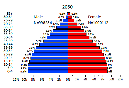
Which of the following variable(s) is/are displayed in population pyramids?
1. Age-groups
2. Sex indicators (male and female)
Select the correct answer using the code given below:
Solution
The correct answer is Both 1 and 2.
Key Points
- A population pyramid
- It is also known as an age structure diagram, which shows the distribution of various age groups in a population.
- A common distribution often used with this type of visualization is female and male populations by age.
- To create a population pyramid using Tableau, first separate the population (measure) into two groups, females and males, and then create "bins" for the age cohorts you want to represent in the population pyramid. Hence, Option 3 is correct.
- A population pyramid is a graphical representation of the age and sex composition of a specific population.
- It consists of two histograms, one for each gender (by convention, men on the left and women on the right) where the numbers are shown horizontally and the ages vertically.
- The numbers by gender and by age depend on interactions between fertility, mortality, and migrations.
- The shape of the pyramid and its variations over the years depends, above all, on the variations in fertility.
- The pyramid can also assume a columnar shape (with vertical sides rather than sloped sides), or have an irregular profile.
- India’s pyramid is bottom-heavy i.e. the Indian population has a larger proportion of children, teenagers, and young adults compared to China’s.
-
Question 15
5 / -1
Which of the following is the oil seed crop?
Solution
The correct option is Mustard.
Key Points
- The oilseeds are produced for extracting edible oils.
- Drylands of Malwa plateau, Marathwada, Gujarat, Rajasthan, Telangana, Rayalseema region of Andhra Pradesh, and Karnataka plateau are oilseeds growing regions of India.
- These crops together occupy about 14 percent of the total cropped area in the country. Groundnut, rapeseed and mustard, soybean, and sunflower are the main oilseed crops grown in India.
Important Points
- Rapeseed and mustard comprise several oilseeds as rai, Sarson, toria, and taramira.
- These are subtropical crops cultivated during the rabi season in north-western and central parts of India.
- These are frost-sensitive crops and their yields fluctuate from year to year.
- But with the expansion of irrigation and improvement in seed technology, their yields have improved and stabilized to some extent.
- About two-thirds of the cultivated area under these crops are irrigated. These oilseeds together occupy only about 2.5 percent of the total cropped area in the country.
- Rajasthan contributes about one-third of production while other leading producers are Haryana and Madhya Pradesh.
- Yields of these crops are comparatively high in Haryana and Rajasthan.
Additional Information
- Foodgrains are dominant crops in all parts of the country whether they have subsistence or commercial agricultural economy.
- On the basis of the structure of grain, the foodgrains are classified as cereals and pulses.
- India produces a variety of cereals, which are classified as fine grains (rice, wheat) and coarse grains (jawar, bajra, maize, ragi), etc.
- Gram and tur are the main pulses cultivated in India.
- Maize is a food as well as fodder crop grown under semi-arid climatic conditions and over inferior soils.
- This crop occupies only about 3.6 percent of the total cropped area. Maize cultivation is not concentrated in any specific region.
- It is sown all over India except Punjab and eastern and north-eastern regions.
- The leading producers of maize are the states of Karnataka, Madhya Pradesh, Bihar, Andhra Pradesh, Telangana, Rajasthan, and Uttar Pradesh.
- The yield level of maize is higher than other coarse cereals. It is high in southern states and declines towards central parts.
- Wheat is the second most important cereal crop in India after rice.
- India produces about 12.8 percent of the total wheat production of the world (2017).
- It is primarily a crop of the temperate zone. Hence, its cultivation in India is done during winter i.e. rabi season.
- About 85 percent of the total area under this crop is concentrated in the north and central regions of the country i.e. Indo-Gangetic Plain, Malwa Plateau, and Himalayas up to 2,700 m altitudes.
- Being a rabi crop, it is mostly grown under irrigated conditions.
- But it is a rainfed crop in Himalayan highlands and parts of Malwa plateau in Madhya Pradesh.
- Gram is cultivated in subtropical areas.
- It is mostly a rainfed crop cultivated during the rabi season in central, western, and northwestern parts of the country.
- Just one or two light showers or irrigations are required to grow this crop successfully.
- It has been displaced from the cropping pattern by wheat in Haryana, Punjab, and northern Rajasthan following the green revolution.
- At present, gram covers only about 2.8 percent of the total cropped area in the country.
- Madhya Pradesh, Uttar Pradesh, Maharashtra, Andhra Pradesh, Telangana, and Rajasthan are the main producers of this pulse crop.
- The yield of this crop continues to be low and fluctuates from year to year even in irrigated areas.
-
Question 16
5 / -1
Which region is known as the 'Orchard of the World?
Solution

Mediterranean climate is confined to the Western portions of Continental masses between 30 degrees and 45 degrees north and south of the equator.
- The basic cause of the Mediterranean climate is the shifting of wind belts.
- Most of the east and northeast margins of the continents are covered by temperate evergreen and deciduous trees.
- The west and south-west margins of the continents are different. They have Mediterranean vegetation.
- It is mostly found in the areas around the Mediterranean sea in Europe, Africa, and Asia, hence the name.
- This kind of vegetation is also found outside the actual Mediterranean region in California in the USA, southwest Africa, southwestern South America, and Southwest Australia.
- These regions are marked for hot dry summers and mild rainy winters.

Explanation:
- Citrus fruits such as oranges, figs, olives, and grapes are commonly cultivated here because people have removed the natural vegetation in order to cultivate what they want to.
- Mediterranean trees adapt themselves to dry summers with the help of their thick barks and wax-coated leaves which help them reduce transpiration.
- Mediterranean regions are known as ‘Orchards of the world’ for their fruit cultivation.
- There isn’t much wildlife here.
Hence the correct Option is Mediterranean Region.
-
Question 17
5 / -1
Which of the following is the correct meaning of ‘Golden Quadrilateral'?
Solution
The correct answer is 1,2, and 3.
Key PointsGolden Quadrilateral
- It is a highway network that connects Delhi, Mumbai, Kolkata, and Chennai, thereby uniting India's major industrial, agricultural, and cultural centers. Hence, option 1 is correct.
- The project began in 2001.
- It was Phase 1 of the larger National Highway Development Project, which was initiated by the same administration in 1998.
- The National Highways Authority of India (NHAI), which is part of the Ministry of Road, Transport, and Highways, is in charge of it.
- When it was completed, the Golden Quadrilateral, which consisted of 5,846 km (3,633 mi) of four/six-lane express roads, was the biggest highway project in India and the sixth-longest in the world. Hence, option 2 is correct.
- It is so named because it connects Delhi, Mumbai, Kolkata, and Chennai, forming a type of quadrilateral. Hence, option 3 is correct.
- The fundamental goal of these superhighways is to shorten the distance and time connecting India's four megacities.
- This project includes the North-South corridor connecting Srinagar (Jammu and Kashmir) and Kanyakumari (Tamil Nadu), as well as the East-West corridor connecting Silchar (Assam) and Porbandar (Gujarat).
- The network also connects other key metropolises such as Pune, Ahmedabad, Jaipur, Kanpur, Surat in the north and Bengaluru, Visakhapatnam, and Bhubaneswar in the south.
- The increased speed limits were possible as a result of the systematic and planned strengthening of the track and its infrastructure by removing bottlenecks in these sections at a rapid pace.
- This featured stronger rails, the installation of 260-meter-long welded rail panels, and the upgrading of bends and slopes, among other things.
-
Question 18
5 / -1
An estate where a cash crop is grown for sale is known as ________.
Solution
The correct answer is Horticulture Farming.
- An estate where a cash crop is grown for sale is known as Horticulture Farming.
Key Points
- Horticulture farming is cultivating plants in an estate to produce food and medicinal ingredients as a cash crop.
- The horticulture includes a wide range of cash crops namely fruits, vegetables, flowers medicinal and aromatic plants mushrooms, plantation crops and spices.
Additional Information
- A kitchen garden is a small farming garden growing fruits and vegetables in the backyard of the house by using kitchen wastewater.
- Slash and burn farming is a farming method that involves the cutting and burning of plants in a forest or woodland.
- Subsistence farming is the practice of growing crops and raising livestock adequate only for one's own use, without any excess for trade.
-
Question 19
5 / -1
One of the dry farming practiced in India is:
Solution
- Farming is the process of systematic and controlled growth of plants or livestock in order to obtain food materials and other raw materials.
- The process of agriculture was initiated thousands of years ago, as civilizations became a part of human life, farming became an everyday chore for the people.
- There are two types of farming based on the terrains in which the crops are cultivated.
- They are known as wetland farming and dryland farming.
| Dryland Farming | Wetland Farming |
| Practised in areas with less than 75 cm of annual rainfall. | Practised in areas with more than 75 cm of annual rainfall. |
| This is practised in dry areas of the country such as North-Western India. | This type of farming is prevalent in the North, North-Eastern, Eastern India and the Western slopes of the Western Ghats. |
| Gram, bajra, millet and peas are important crops. | Rice, jute, wheat, cotton, sugar cane, etc., are important crops. |
| Entirely dependent on rainfall. | Not much dependent on rainfall. |
| They follow a single or intercropping system. | They follow intercropping or double cropping system. |
Thus, one of the dry farming practised in India is millet.
-
Question 20
5 / -1
Which of the following is a non-renewable resource?
Solution
The correct answer is Coal.
- Non-Renewable Resources:
- The sources that cannot be replaced or reused once they are destroyed are called the Non-renewable resources.
- These are limited resources. so these are used limitedly.
- These are not environmentally friendly because the amount of carbon emission is high.
- The cost of these resources is high.
- They are not pollution-free.
- They require low maintenance cost.
- Coal, oil, nuclear energy, petroleum, natural gas, batteries, shale gas, phosphate are some examples.
Additional Information
- Renewable Resources:
- Resources that are used by humans since human life exists.
- These resources are used by our ancestors for their daily purposes like lighting, shelter, transportation, cooking, heating, protection from harm.
- These are also known as non-conventional sources of energy.
- For example Soil, water bodies, sun, wind, tidal energy, geothermal, forest, mountains, wildlife, atmospheric resources.
- These can be used unlimited.
- They are environment friendly.
- The cost is low.
- They are pollution-free.
- They require high maintenance costs.
- They are sustainable resources.
- They cause no harm to life to exist on earth.
-
Question 21
5 / -1
Which one of the following industries uses bauxite as a raw material?
Solution
Bauxite is a significant raw material of primary significance for the aluminum industry.
Key PointsUse of Bauxite:
- Bauxite is formed by surface weathering of clay rocks around the tropical region and composer of aluminum oxide Al(OH)3.
- It contains 15%–25% aluminum and only ore used for commercial extraction for aluminum.
- The bauxite occurs in near-surface layers and is usually mixed with clay minerals, iron oxide, and titanium dioxide.
- Bauxite is the primary source of aluminum to make cement that is used for construction.
- Aluminum is used for transport carriers, consumer durables, packaging, electrical, machinery equipment, refractory bricks, and abrasives.
- The principal uses of bauxite are multipurpose covering metallurgy, chemical industries, as raw material in building and road aggregates.
- Bauxite is the best and only material for making aluminum metal.
- Bauxite is used in the chemical industry, refractory brocks, abrasive, cement, steel, and petroleum.
- Lateritic bauxite is often used as a building material.
- The calcined bauxite, produced by sintering of high-alumina in rotary, round, or shaft kilns at high temperature, is used as an anti-skid road aggregate which is used in selected areas to prevent road accidents.
Hence, Aluminum is the correct answer.
-
Question 22
5 / -1
Crop rotation helps to
Solution
The correct answer is option 4.
Key Points
- Crop rotation is significant in farming as crops cannot compete for nutrients and eliminate pests and diseases.
- Three main types of agriculture use crop rotation include:
- Subsistence farming- It is a practice of growing crops and raising livestock sufficient only for one's own use, without any surplus for trade
- Commercial farming- mixed farming and plantations.
- Arable farming- is growing crops in fields, which have usually been ploughed before planting.
- Crop rotation is essential in subsistence, commercial and arable farming to reduce the loss of soil nutrients.
- For instance, when a farmer plants maize in one season, he should rotate them with beans since less nitrogen will be used.
-
Question 23
5 / -1
Which settlements are widespread in the Gujarat plain and some parts of Rajasthan?
Solution
The correct answer is Fragmented Settlements.
Key Points
Semi-Clustered or fragmented Settlements -
- In this settlements may result from a tendency of clustering in a restricted area of dispersed settlement.
- More often such a pattern may also result from segregation or fragmentation of a large compact village
- In this case, one or more sections of the village society choose or are forced to live a little away from the main cluster or village.
- The land-owning and dominant community occupies the central part of the main village, whereas people of lower strata of society and menial workers settle on the outer flanks of the village.
- Such settlements are widespread in the Gujarat plain and some parts of Rajasthan. Hence the correct answer is option 4.
-
Question 24
5 / -1
Geometric representation of age structure is a characteristic of
Solution
Concept:- Population - refers to a group of individuals of the same species within a community in a defined area.
- A population can be characterized on the basis of various attributes like growth of a population, sex ratio, age structure, etc.
Key Points
- A population at any given point of time comprises of individuals of different age groups.
- Age structure - The percentage of individuals of a given age or age group is known as age structure or distribution, which is an important population attribute.
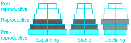
- Age pyramid - It is the geometric representation of age structure that results from the plotting of the age distribution of a population.
- For a human population, 3 age groups are considered:
- Pre-reproductive
- Reproductive
- Post-reproductive
- The age pyramids usually include both male and female individuals.
Explanation:
- The shape of the pyramid shows the growth status of a population.
- They can be of 3 basic types:
- Expanding - Pre-reproductive group is maximum and post-reproductive group is minimum.
- Stable - The pre-reproductive and reproductive groups are almost equal, while the post-reproductive is less.
- Declining - Pre-reproductive group is lesser than the other age groups.
Therefore, geometric representation of age structure is a characteristic of population.
Additional Information
- Biotic community - refers to a group of organisms that live and interact with each other within an environment or habitat.
- Landscape - refers to the visible landforms that can be seen in a particular area at one glance.
- Ecosystem - is a functional unit comprising organisms of a given area interacting with the physical environment and also among themselves, such that flow of energy leads to a clearly defined trophic structure, biodiversity and material cycles.
-
Question 25
5 / -1
What was the first program telecasted on Doordarshan?
Solution
The correct answer is Krishi Darshan.
Key PointsDoordarshan
- The first program to be telecast on Doordarshan was Krishi Darshan, which began on 26th January 1967 and is remembered as the longest-running TV program.
- In 1982 Doordarshan came into existence as a national broadcaster and reached all parts of the country.
- Doordarshan was Launched - on September 15, 1959.
- On 15 September 1959, the Government of India launched Doordarshan, or DD in short, India's public service broadcaster in Delhi.
- Starting, as an experiment with a small 5 KW transmitter and an improvised studio, DD became a national broadcaster in 1982.
- On 15 September 1959, at the studio of All India Radio, Delhi, the first TV channel in India started an experimental telecast with a small transmitter and a makeshift studio, adopting the brand Doordarshan, Hindi for television.
- The Delhi Doordarshan Centre was inaugurated by Dr. RajendraPrasad, the first Indian President in 1959.
- Doordarshans Mumbai center began to telecast its programmes on 1st May 1972.
- Colour television was introduced on 15th August 1982.
-
Question 26
5 / -1
The best solution for overcoming the evil effects of small and uneconomic holdings is: _________.
Solution
- Cooperative farming is an operation in which an agency or organization helps an individual on their holdings or land by contributing for inputs like equipments, fertilisers, etc.
- This helps the holder of the plot to overcome the shortcomings of the small plot.
-
Question 27
5 / -1
Tarapur nuclear power plant is located in ________.
Solution
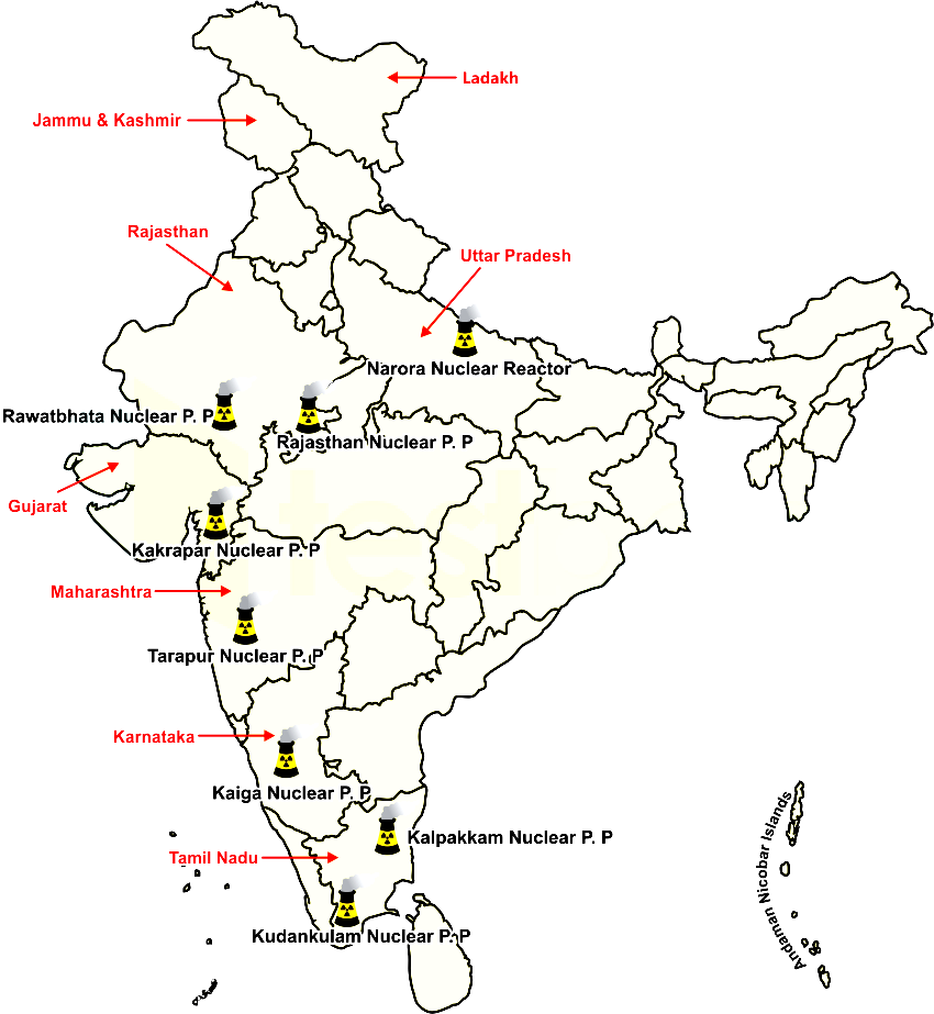
The correct answer is Maharashtra.
Key Points
- Tarapur Atomic Power station is located in Tarapur, Maharashtra.
- It was the first commercial atomic power station of India commissioned on 28th October 1969.
- It was commissioned under 123 agreements signed between India, the United States, and International Atomic Energy Agency.
- The station is operated by the National power corporation of India.
Additional Information
Other important Atomic Power stations in India -
| Nuclear Power Plant(P.P) | Location |
| Kaiga Atomic Power plant | Karnataka |
| Kakarapar Atomic power station | Gujarat |
| Narora Nuclear power plant | Uttar Pradesh |
| Kalapakkam Nuclear plant | Tamil Nadu |
| Rawatbhata Nuclear P.P | Rajasthan |
| Tarapur Nuclear P.P | Maharashtra |
| Kudankulam Nuclear P.P | Tamil Nadu |
-
Question 28
5 / -1
The main watchdog of International Trade is
Solution
The main watchdog of International Trade is the World Trade Organization (WTO).
- It is an international body which promotes free trade by persuading countries to abolish import tariffs and other barriers.
- The WTO is the only international agency overseeing the rules of international trade.
- The WTO is run by its member governments.
- It was established on 1 January 1995 in Geneva, Switzerland.
-
Question 29
5 / -1
What is Terrace Farming?
Solution
The correct answer is Terraces are made on the steep slopes so that flat surfaces are available to grow crops.
Key Points
- Terrace farming is a method of growing crops on the sides of hills or mountains by planting on graduated terraces built into the slope.
- Terraces are made on the steep slopes so that flat surfaces are available to grow crops.
- It is efficient and often the only solution for hilly farmlands.
- The essential feature of terrace agriculture is excavating and moving topsoil to form farmed areas and ridges.
Thus, we can say that the above statements about terrace farming are correct.
-
Question 30
5 / -1
Open Sky Policy5 is related with?
Solution
The correct answer is Air Transport.
Key PointsOpen Sky Policy5
- Air transport terminals are called airports.
- Air transport cost is comparatively very high, and therefore, it is mainly used for passenger services.
- Only light and valuable cargo is dispatched by cargo aircraft.
- In order to help Indian exporters and make their export more competitive, the Government of India introduced the ‘open sky policy5 for cargo.
- Under this policy, any foreign airlines or association of exporters can bring freighters to the country for the upliftment of cargo.
-
Question 31
5 / -1
The Green Revolution in India was an introduction of High Yielding Varieties(HYV) of seeds for__________.
Solution
The correct answer is Wheat.
The Green Revolution in India was an introduction of High Yielding Varieties(HYV) of seeds for Wheat.
- HYV seeds are those seeds that produce huge quantities of crops particularly wheat and rice.
- The regular supply of water, maximum use of fertilizers, and use of pesticides in an accurate proportion are needed to use these seeds.
- HYV are seeds are of better quality than normal quality seeds.
- The yield from these seeds is slightly higher than the normal ones.
- These seeds have a good immune system to fight insects and other diseases.
- Under the new agricultural strategy, special emphasis has been placed on the development and widespread adoption of HYV seeds.
- The actual area under HYV by the end of the 7th plan was only 63.1 hectares.
- In 1998-99, the coverage rose to 78.4 million hectares.
-
Question 32
5 / -1
Tea and coffee fall under which category of crops in India?
Solution
The correct answer is Plantation crops.
Key Points
- Plantation crops
- The term plantation crops refer to those crops which are cultivated on an extensive scale in a contiguous area owned and managed by an individual or a company.
- The crops include tea, coffee, rubber, cocoa, coconut, areca nut, oil palm, palmyra, and cashew.
- These are high-value commercial crops of greater economic importance and play a vital role in improving the Indian economy, especially in view of their export potential, employment generation and poverty alleviation, particularly in the rural sector.
- Tea, Coffee and rubber are dealt with by the Ministry of Commerce, while Coconut, cashew nut, cocoa, areca nut, oil palm yrah come under the Ministry of Agriculture.
Additional Information
- Horticulture crops
- Horticultural crops include fruits, vegetables, medicinal, aromatic, and ornamental plants.
- These crops are important dietary nutritional components and sources of medicines and aroma along with significant esthetic values for human beings.
- Adoption of horticulture is also becoming essential to meet the demands of fruits, vegetables, and other horticultural products for the fast-growing population of the world.
- Cash crops
- Cash crops are agricultural crops that are planted for the purpose of selling on the market or for export to make a profit, as distinguished from subsistence crops planted for the purpose of self-supple of the farmer.
- Cash crops are grown on a large scale and sometimes compete with the land use and resource requirements of the local community.
- Food crops
- The crops that are grown to feed the human population are known as food crops.
- There are a number of food crops grown in the country.
- Cassava, maize, plantains, potatoes, rice, sorghum, soybeans, sweet potatoes, wheat, and yams are some of the leading food crops around the world.
-
Question 33
5 / -1
What is the objective of the Smart Cities Mission?
Solution
The correct answer is All of the above.
Key Points
Smart Cities Mission -
- The objective of the Smart Cities Mission is
- to promote cities that provide core infrastructure,
- a clean and sustainable environment
- give a decent quality of life to its citizens.
- Hence the correct answer is option 4.
- One of the features of Smart Cities is to apply smart solutions to infrastructure and services in order to make them better.
- The focus is on sustainable and inclusive development and the idea is to look at compact areas and create a replicable model, which will act as a lighthouse to other aspiring cities.
- This MIssion is India's urban renewal and retrofitting programme with the mission to develop smart cities across the country, making them citizen-friendly and sustainable.
- Launched in June 2015, the mission initially included 100 cities with the deadline for completion of the projects set between 2019 and 2023.
-
Question 34
5 / -1
Identify the Indian seaport which provides port facilities to its landlocked neighbour countries?
Solution
The correct answer is Kolkata seaport.
Key PointsKolkata seaport.
- Kolkata Port is the only riverine Major Port in India, situated 232 kilometers upstream from the Sandheads, having arguably the longest navigational channel amongst Major Ports of India and its navigational channel is one of the longest in the world.
- KoPT is India’s oldest operational port and the first among the 12 major ports (government-owned) of India. Kolkata Port System includes three ports:
- Kolkata
- Haldia
- Sagar Island
- The port facility has aided in industrialization, employment generation, and major economic activity in the region while serving a vast hinterland as well as landlocked neighbouring countries such as Bhutan and Nepal.
- The river Hooghly, on which it is located, has many sharp bends and is considered a difficult navigational channel.
- Throughout the year, dredging activities have to be carried out to keep the channel open.
- The Farakka Barrage, built-in 1975, reduced some of the port’s woes as Ganga waters were diverted into the Bhagirathi-Hooghly system.
-
Question 35
5 / -1
Which group refers to dependent population in the population pyramid?
Solution
The correct answer is Above 60 years group.
Key Points
- The population pyramid is a graphical representation of the age and sex composition of a specific population.
- Age structure represents the number of people of different age groups and an important indicator of population composition.
- Demographers express the share of the dependent age groups using a metric called the 'age dependency ratio'. This measures the ratio between 'dependents' (the sum of young and old) to the working-age population that is aged between 15 to 64 years old.
- The large size of the population in the age group of 15- 59 indicates a large working population.
- A greater proportion of the population above 60 years represents an ‘aging population’ or ‘the elderly population’ which requires more expenditure on health care facilities.
- A high proportion of the young population would mean that the region has a high birth rate and the population is youthful. This population is known as children and young adolescents who are under 15 years old.
 Confusion Points
- The dependent population will include those of school age and those over the age of retirement.
- The male and female who are within 15-59 years are called independent or active population.
- The age groups of 0-14 and over 60 years are called dependent populations.
- This question is taken from UPPSC 2013 Official Paper and the answer to this question is marked according to the official answer key.
Additional Information
- Population pyramids are important graphs for visualizing how populations are composed when looking at groups divided by age and sex.
- There are three trends in population pyramids: expansive, constrictive, and stationary.
- The population pyramid can be used to represent additional characteristics of a population, such as marital status, race, or geographic location.
-
Question 36
5 / -1
Arable land in the irrigated zones of India is becoming saline because of ________.
Solution
The correct answer is option 2, i.e. Over-irrigation.
Arable lands of India are becoming saline because of Over-irrigation.
- The areas having intensive cultivation and excessive use of irrigation, the soil is losing its fertility and becoming saline.
- Dry climates having excessive irrigation create capillary action by which deposition of salt occurs on the top layer of the soil make it saline.
- Because of over-irrigation, a large part of arable land is irrigated zones of the country are becoming saline.
- This problem occurs mainly in the green revolution areas. Around half of the total land of India is under some form of degradation.
- Soil erosion and land degradation are caused by many factors like human encroachments, wind and water movements, deforestation, over-grazing, the use of chemical fertilizers and pesticides, etc.
-
Question 37
5 / -1
Bewar, Podu and Bringa are types of
Solution
- Every region follows different agricultural practices.
- Depending on the type of crop and scale of farming various agricultural practices are adopted.
Primitive Farming:
- This type of farming is still practised in few pockets of India.
- Primitive agriculture is practised on small patches of land with the help of primitive tools like hoe, dao and digging sticks, and family/community labour.
- This type of farming depends upon monsoon, natural fertility of the soil and suitability of other environmental conditions to the crops grown.
About slash and burn agriculture:
- It is a type of primitive farming in which the farmer cultivates on a plot of land temporarily.
- When he finds the land infertile to grow due to soil exhaustion, they move on to another plot.
- It is largely practised in the north-eastern region of India, including Assam, Manipur, Mizoram, Nagaland, etc.
- This way of farming is also known as "Jhum Kheti".
- It is a shifting cultivation practice.
- It is also known as fire-fallow cultivation.
- Forest land is cleaned and ashes are added to the soil.
- Cultivated spots/ areas are usually small.
- Short periods of crop occupation alternate with long fallow periods.
- Field rotation is practised instead of crop rotation.
Shifting cultivation in India:
Jhoom | North-eastern India |
Bewar or Dahiya | Madhya Pradesh |
Zara or Erka | Southern states |
Valre or Waltre | South-eastern Rajasthan |
Podu or Penda | Andhra Pradesh |
Kumari | Western Ghats |
Pama Dabi or Koman or Bringa | Odisha |
| Khil | Himalayan belt |
| Kuruwa | Jharkhand |
| Jhumming | North-eastern states |
Shifting cultivation in the world:
- Milpa in Central America.
- Chitemene or Tavy in Africa.
- Chena in Sri Lanka.
- Conuco in Venzuela.
- Roca in Brazil.
- Masole in Central Africa.
- Ladang in Indonesia.
- Ray in Vietnam.
Thus, Bewar, Podu and Bringa are types of primitive farming.

Commercial farming:
- In commercial farming, crops are grown and animals are reared for sale in the market.
- The area cultivated and the amount of capital used is large.
- Most of the work is done by machines.
- Commercial farming includes commercial grain farming, mixed farming and plantation agriculture.
Subsistence farming:
- Subsistence farming, a form of farming in which nearly all of the crops or livestock raised are used to maintain the farmer and the farmer’s family, leaving little, if any, surplus for sale or trade.
- Its characteristics are no surplus, distress sale, less or no use of fertilizers etc.
Plantation farming:
- Plantations are a type of commercial farming where a single crop of tea, coffee, sugarcane, cashew, rubber, banana or cotton are grown.
- A large amount of labour and capital are required.
- The produce may be processed on the farm itself or in nearby factories.
- The development of a transport network is thus essential for such farming.
-
Question 38
5 / -1
Suez Canal is connected with
Solution
The Suez Canal is an artificial sea-level waterway in Egypt, connecting the Mediterranean Sea to the Red Sea.
Key Points
Suez Canal was opened on 17 November 1869, after 10 years of construction.
- It allows ships to travel between Europe and South Asia without navigating around Africa thereby reducing the sea voyage distance between Europe and India by about 7,000 kilometres.
- A new stretch of the canal was just opened in 2015. The northern terminus is Port Said, where there are two outlets to the sea; the southern terminus is Port Tewfik at the city of Suez, where there is one outlet to the sea.
- When built, the canal was 164 km long and 8 m deep. After several enlargements, it is 193.30 km long, 24 m deep, and 205 meters wide.
- The canal is single-lane with passing places in the Ballah Bypass and the Great Bitter Lake. It contains no locks, seawater flows freely through it. In general, the canal north of the Bitter Lakes flows north in winter and south in summer.
- The canal is owned and maintained by the Suez Canal Authority (SCA) of Egypt. Under the Convention of Constantinople, it may be used "in time of war as in the time of peace, by every vessel of commerce or of war, without distinction of flag."
- In August 2014, construction was launched to expand and widen the Ballah Bypass, for 35 km (22 mi), costing $8.4 billion, to speed the canal's transit time.
Hence, the correct answer is The Mediterranean Sea and the Red Sea.
Additional Information
- The 193 km Suez Canal is so important to world trade that world powers have fought over it.
- About 12% of world trade passes through the canal each year, everything from crude oil to grains to coffee.
- Without the Suez canal, a supertanker carrying Mideast crude oil to Europe would have to travel an extra 6,000 miles around Africa's Cape of Good Hope.
- As it has no locks, it can even handle aircraft carriers.
- The canal's location makes it a key link for shipping crude oil and other hydrocarbons from countries such as Saudi Arabia to Europe and North America.
-
Question 39
5 / -1
Ambala, Jalandhar, and Mhow are an example of which type of town?
Solution
The correct answer is Garrison Cantonment towns.
Key Points
On the basis of specialised functions, Indian cities and towns can be broadly classified as follows -
- Industrial towns -
- Industries constitute the prime motive force of these cities, such as Mumbai, Salem, Coimbatore, Modinagar, Jamshedpur, Hugli, Bhilai, etc.
- Garrison Cantonment towns -
- These towns emerged as garrison towns such as Ambala, Jalandhar, Mhow, Babina, Udhampur, etc.
- Hence the correct answer is option 2.
- Commercial towns -
- Towns and cities specialising in trade and commerce are kept in this class. Kolkata, Saharanpur, Satna, etc., are some examples.
- Mining towns -
- These towns have developed in mineral-rich areas such as Raniganj, Jharia, Digboi, Ankleshwar, Singrauli, etc.
-
Question 40
5 / -1
Which among the following is the disadvantage of road transport?
Solution
The correct answer is Heavy goods cannot be taken to long distances.
Key PointsDisadvantages of road transport
- Road transport is costly.
- It results in air pollution.
- Heavy goods cannot be taken to long distances.
- Road transport is more accident-prone.
Advantages of roadways.
- When compared to construction costs of railway lines, the construction cost of roads is much lower.
- Undulating topography and dissected terrain can be traversed through roads.
- Roads will help in traveling in tough mountainous regions like the Himalayas and roads will help in negotiating slopes of higher gradients.
- For transporting smaller amounts of goods and for transporting few persons, roadways are the most economical mode of transport.
- Roadway transportation has reduced the cost of unloading and loading.
- Roadways provide door-to-door services.
- For other modes of transportation like ships, aircraft, and railways; road transport acts as a feeder.
- Roadways can be maintained and built easily.
- One of the largest road networks is in India.
-
Question 41
5 / -1
Least polluting energy generating technique among the following is:
Solution
As society advances, we are discovering more pollutants that are contributing to negative climate change effects and global warming. Many of these pollutants come from our manufacturing and power generating industries, and no matter how much they are minimized, there are always going to some pollutants that will enter our atmosphere.
1) Fission based nuclear energy:
- Nuclear is a zero-emission clean energy source.
- It generates power through fission, which is the process of splitting uranium atoms to produce energy. The heat released by fission is used to create steam that spins a turbine to generate electricity without the harmful byproducts emitted by fossil fuels.
- According to the Nuclear Energy Institute (NEI), the United States avoided more than 476 million metric tons of carbon dioxide emissions in 2019. That’s the equivalent of removing 100 million cars from the road and more than all other clean energy sources combined.
- It also keeps the air clean by removing thousands of tons of harmful air pollutants each year that contribute to acid rain, smog, lung cancer, and cardiovascular disease.
2) Magneto-hydrodynamic:
- Magnetohydrodynamics is the study of the magnetic properties and behavior of electrically conducting fluids.
- Examples of such magnetofluids include plasmas, liquid metals, salt water, and electrolytes.
- MHD power generation is a new system of electric power generation that is said to be of high efficiency and low pollution.
- As its name implies, Magneto Hydro Dynamics (MHD) concerned with the flow of a conducting fluid in the presence of the magnetic and electric fields.
3) Thermal Power:
- A thermal power station is a power station in which heat energy is converted to electric power.
- In most, a steam-driven turbine converts heat to mechanical power as an intermediate to electrical power. Water is heated, turns into steam, and drives a steam turbine which drives an electrical generator.
- Thermal power plants are known to pump out a lot of greenhouse gases and ash, which are by-products of burning fossil fuels.
4) Photovoltaics (PV)
- It is the conversion of light into electricity using semiconducting materials.
- A photovoltaic system employs solar modules, each comprising a number of solar cells, which generate electrical power. Solar energy systems/power plants do not produce air pollution, water pollution, or greenhouse gases. However, some toxic materials and chemicals are used to make the photovoltaic (PV) cells that convert sunlight into electricity.
- Some solar thermal systems use potentially hazardous fluids to transfer heat.
Thus, Fission based nuclear energy is the least polluting energy-generating technique.
-
Question 42
5 / -1
The base of sustainable development is
Solution
The correct answer is All of the above.
Key Points
- Sustainable development involves the execution of programs that offer economic benefits in the present without limiting social and environmental choices that may be available to people in the future or in other places.
- ECOSOC operates at the center of the UN system's work on all three pillars of sustainable development—economic, social and environmental.
- Social sustainability is “a process for creating sustainable successful places that promote wellbeing, by understanding what people need from the places they live and work.
- Social sustainability is an often overlooked aspect of sustainability, as sustainable development discussions often focus on the environmental or economic aspects of sustainability.
- All three dimensions of sustainability must be addressed to attain the most sustainable outcome possible.
- Sustainable development is an approach to economic planning that attempts to foster economic growth while preserving the quality of the environment for future generations.
Additional Information
- The environmental approach examines the adaptation of individuals to their surroundings throughout their lives, as well as their ability to shape or change this environment.
- Environment and its positive use is a key factor for sustainable development.
- Negative impact on the environment through unplanned development may mar sustainability as a whole.
- The development which creates complete social and environmental harmony is only classed as sustainable.
-
Question 43
5 / -1
Dry farming is possible because of
Solution
The correct answer is the Utilization of groundwater potential.
- Dry agriculture is the cultivation done in dry and semi-dry areas where the average annual rainfall is about 75 cm.
Key Points
- Dryland farming or rainfed farming is the technique of doing agriculture without irrigation.
- Crops are grown without irrigation by accumulating the limited moisture available under them.
- Due to the lack of rainfall, constant efforts are made to maintain and increase the moisture content of the soil.
- Features of dry agriculture are that it is cultivated in those areas where there is a lack of moisture for about 8 months in a year.
- Jaisalmer and Barmer region of Rajasthan receives less than annual rainfall of about 20 cm.
- Water scarcity is a permanent problem in these areas.

- The importance of dry agriculture is that in a country like India, pulses are an important source of protein.
- About 85% of the country's pulses, 75% of oilseeds, 80% maize, and 95% sorghum are grown in dry agricultural regions through dry agriculture techniques.
-
Question 44
5 / -1
Migrants who move into a new place are called ______.
Solution
The correct answer is Immigrants.
- Migrants who move into a new place are called Immigrants.
Key Points
- Immigrants are the people who come to a new place or country to live there permanently.
Additional Information
- Emigrants are the people who has gone to live in another country.
- Sheltered people are the ones who acquire shelter given either by the government or native people.
- These people are displaced due to various reasons like natural calamities and war.
- Displaced people are the ones who move from their native place to another place due to some circumstances.

- People who are displaced can also be called sheltered after their settlements.
-
Question 45
5 / -1
Which of the following is not a cause of low productivity in Indian agriculture ?
Solution
The correct answer is Cooperative farming.
Key Points
- Efficiency and effectiveness are two wings of Productivity.
- These two are essential for a productive industry.
- Low productivity occurs due to lack of adequate machinery, lack of finances for farmers, lack of good quality seeds and fertilizers and ownership of land.
- Other factors include:
- Inadequate inputs availability
- Sub-division and fragmentation of land holdings
- Poor finance and marketing facilities
- The co-operatives and other institutional agencies have not been able to eliminate the village money-lenders.
- Storage facilities for farmers are not still available to preserve their agricultural products for a better price.
-
Question 46
5 / -1
The place "Noonmati" in India, is related to which among the following?
Solution
The correct answer is Petroleum Industry.
- The place "Noonmati" in India, is related to Petroleum Industry.
Key Points
- Noonmati is a locality located in Guwahati, Assam.
- It was commissioned by the Indian Oil Company on 1 January 1962.
- It was the first oil refinery which was also known as the Guwahati Refinery

- Gujarat is the largest salt-producing state.
- The first Paper Industry was set up at Serampore in Hooghly district of West in 1832.
- The first Textile Industry was set up in Kolkata in 1818.
- The first successful textile mill was established at Bombay in 1854.
-
Question 47
5 / -1
Which of the following is the main factor of desertification?
Solution
Explanation:
Desertification:
- Desertification is the conversion of fertile land into a barren area with loose soil cover.
- This happens due to excessive soil erosion which is again on the rise due to the increasing population.
- Removal of the top layer of the soil exposes the lower, hard and rocky layers.
- This soil has less humus and is less fertile.
- Gradually the fertile land gets converted into deserts.
- Desertification means a process of spread of desert that occurs due to degradation of environment, cutting of trees, soil erosion etc.
- It can be natural or manmade.
- The main causes for desertification are over cultivation of poor soils, overgrazing by animals, excessive cutting of fuelwood and inappropriate irrigation practises resulting in salinization.
Thus, over-grazing is the main factor of desertification.
-
Question 48
5 / -1
Cities accommodating population sizes between one to five million are called ______
Solution
The correct answer is Metropolitan.
Key Points
Classification of Towns on the basis of Population Size -
- Urban centre with population of more than one lakh is called a city or class I town.
- Cities accommodating population sizes between one to five million are called metropolitan cities and more than five million are mega cities.
- Hence the correct answer is option 1.
- The majority of metropolitan and mega cities are urban agglomerations.
-
Question 49
5 / -1
Which one of the following rivers did the highest gully erosion of the soil in Rajasthan?
Solution
The correct answer is Chambal.
Key Points
- Chambal river caused the highest gully erosion of the soil in Rajasthan.
- The Chambal River is a tributary of the Yamuna river.
- Due to gully erosion of soil by the Chambal river the area is degraded ravines, locally called Bihads.
Additional Information
- Luni river:
- It originates in the Naga Hills of Aravalli Range, near Pushkar valley in Ajmer district.
- The total length of Luni is about 511 km.
- Banas river:
- Banas River in Rajasthan state rises near Kumbhalgarh.
- The Banas is a seasonal river that is often dry in the hot months, but it is still a source of irrigation.
- Its main tributaries are the Berach and Kotari rivers.
- Mahi river:
- Mahi River rises in the western Vindhya Range, just south of Sardarpur, and flows northward through Madhya Pradesh state.
-
Question 50
5 / -1
"Slash and Burn Agriculture" is the name given to
Solution
The correct answer is Shifting cultivation.
- Slash and burn agriculture is a type of primitive subsistence agriculture.
- it is also called Jhum agriculture.
- It is a shifting cultivation practice.
- It is also known as fire-fallow cultivation.
Key Points
- Salient features of shifting agriculture -
- Forest land is cleaned and ashes are added to the soil.
- cultivated spots/areas are usually small.
- Short periods of crop occupation alternate with long fallow periods.
- Field rotation is practised instead of crop rotation.
Additional Information
- Extensive subsistence agriculture is a technique where a vast expanse of land is cultivated to yield minimal output for primary consumption.
- Mixed farming is a type of farming that involves both the growth of crops and the raising of life to the class.
- Extensive Commercial Grain cultivation is an extensive and mechanized form of agriculture.
- It specializes in a single crop.
- The farms are very large.
- Low yield per acre but high yield per person.
Note: Other types of farming have been explained here:
Primitive subsistence agriculture | It is the oldest form of farming, practised on small plots of land with the help of primitive tools. |
Commercial farming | It refers to the farming for profit where crops are grown for sale in the market. Mainly t is grown in large farms. |
Shifting cultivation | It refers to the farming in which farmer cultivates on a plot of land temporarily, and when finding the land infertile to grow due to soil exhaustion, they move on to another plot. |


 ×
×

 Sign in
 Profile
 Signout