-
Question 1
5 / -1
In which type of farming, the land is used for growing food and fodder crops and also for rearing livestock?
Solution
Mixed farming is a type of farming that involves both the growing of crops and the raising of livestock.
- Such agriculture occurs across Asia and in countries such as India, Malaysia, Indonesia, Afghanistan, South Africa, China, Central Europe, Canada, and Russia.
- Though at first it mainly served domestic consumption, countries such as the United States and Japan now use it for commercial purposes.
 Key Points
Mixed farms are moderate in size and usually, the crops associated with them are wheat, barley, rye, oats, maize, fodder, and root crops.
- Fodder crops are an important component of mixed farming.
- Crop rotation and intercropping play an important role in maintaining soil fertility.
- Equal emphasis is laid on crop cultivation and Animal husbandry.
- Animals like cattle, sheep, pigs, and poultry provide the main income along with crops.
Hence, we can say that in Mixed farming, the land is used for growing food and fodder crops and also for rearing livestock.
 Additional Information
- Subsistence farming: It occurs when farmers grow food crops to meet the needs of themselves and their families on smallholdings.
- Subsistence agriculturalists target farm output for survival and for mostly local requirements, with little or no surplus.
- Planting decisions occur principally with an eye toward what the family will need during the coming year, and only secondarily toward market prices.
- Intensive farming: It is a type of agriculture, both of crop plants and of animals, with higher levels of input and output per unit of agricultural land area.
- It is characterized by a low fallow ratio, higher use of inputs such as capital and labour, and higher crop yields per unit land area.
- Commercial farming: It is the farming method in which plant and livestock production is practised with the intention of selling the products on the market.
- Subsistence agriculture is practised in a small area only.
- On the other hand, a large area is necessary to practice commercial agriculture.
-
Question 2
5 / -1
Population explosion occurs due to
Solution
Key PointsPopulation explosion:
- Population Explosion is a sudden, large increase in the size of a population.
- The major factors that are responsible for population explosion are illiteracy, reduced mortality, increased birth rate/fertility
- Improved medicare facility is one of the major causes of the population explosion.
- The most simple method to control population explosion is to encourage small families about different control measures such as contraceptives.
- Periodic abstinence is the natural measure for control.
- It refers to the rapid increase in the population of an area among human beings.
- Furthermore, it is a situation where the economy is not capable of coping with the increasing demand of its population.
Causes of population explosion:
- Falling Mortality Rate
- High birth rate
- The imbalance between births and deaths.
- Lack of Female Education
- Underutilized contraception
Hence, the population explosion occurs due to High Birth Rates as well as Low Death rates.
-
Question 3
5 / -1
The most common areas of nomadic herding are
Solution
The correct answer is dry areas.
Key Points
- One of the most ancient forms of herding is nomadic herding.
- Nomadic herders roam in small tribal or extended family groups and have no home base.
- Nomads live in arid and semiarid parts of Africa, Asia, and Europe, and the tundra regions of Asia and Europe.
- Nomadic herding, at present, is mainly concentrated in Saharan Africa (Mauritania, Mali, Niger, Chad, Sudan, Libya, Algeria), the southwestern and central parts of Asia, the northern parts of the Scandinavian countries (Norway, Sweden, Finland) and northern Canada.
-
Question 4
5 / -1
The east-west corridor has the easternmost section-Easternmost section in the east-west corridor is-
Solution
The correct answer is Silchar.
Key Points
- The North-South–East-West Corridor (NS-EW) is the largest ongoing highway project in India.
- East end: Silchar.
- West end: Porbandar.
- North end: Srinagar.
- South end: Kanyakumari/Kochi.
Additional Information
- The NS–EW project is managed by the National Highways Authority of India.
- It is under the Ministry of Road Transport and Highways.
-
Question 5
5 / -1
Seasonal migration of people with their animals is called
Solution
Farming or Agriculture is the science, art, and practice of cultivating plants and livestock. Agriculture was the key development in the rise of sedentary human civilization, whereby farming of domesticated species created food surpluses that enabled people to live in cities.

- Transhumance is a type of pastoralism or nomadism, a seasonal movement of livestock between fixed summer and winter pastures.
- They migrate with their animals depending on the seasons.
- In montane regions, it implies movement between higher pastures in summer and lower valleys in winter.
- Herders have a permanent home, typically in valleys.
- Generally, only the herds travel, with a certain number of people necessary to tend them, while the main population stays at the base.
- In contrast, horizontal transhumance is more susceptible to being disrupted by climatic, economic, or political change.
- It is often important to pastoralist societies, as the dairy products of transhumance flocks and herds (milk, yogurt, butter, and cheese) may form much of the diet of such populations.
Hence, the correct answer is Transhumance.
-
Question 6
5 / -1
Which of the following can be categorized as a primary activity?
Solution
Activities that generate income are termed economic activities. On the basis of economic activities, the Indian economy can be divided into 3 major sectors that are the primary sector, the secondary sector, and the tertiary sector. There are two other sectors also, called quaternary and quinary activity.

- The primary sector is in which industries are engaged in the production or extraction of natural resources such as crops, oil, and ores, etc.
- The secondary sector of the economy produces finished goods from the raw materials extracted by the primary economy.
- The tertiary sector of the economy is also known as the service industry. This sector sells the goods produced by the secondary sector.

Sector of Economy | Nature of activity | Examples |
Primary | Extraction of raw materials | Dairy, Hunting and gathering, pastoral activities, fishing, forestry, agriculture, and mining and quarrying. |
Secondary | Manufacturing | Manufacturing processing and construction (infrastructure) industries. |
Tertiary | Services | Trade and commerce, retail trading services, communication services |
From the above table, it can be clearly understand that coal mining is a primary activity. Handicraft, car manufacturing, etc. are related to the transformation of raw materials into goods. So, these are secondary activities. Teaching means providing services that come under the service sector of the economy.
-
Question 7
5 / -1
The third stage of demographic transition is marked by
Solution
Demographic transition theory can be used to describe and predict the future population of any area. This theory tells us about three states of demographic transitory cycle. Important Points
Demographic Transition Theory
- It suggests that population growth is linked to overall levels of economic development and every society follows a typical pattern of development-related population growth.
There are three basic phases of population growth.
- The first stage has high fertility and high mortality because people reproduce more to compensate for the deaths due to epidemics and variable food supply. It is characterised by a high birth rate, death rate and low rate of population growth.
- The Second Stage is called the stage of Population Explosion. Fertility is still high at the start of the second stage, but it gradually decreases.
- Fertility and mortality both drop dramatically in the third stage. It has a declining birth rate, a low and stable mortality rate, and a rapidly growing population. Hence, option 3rd is correct.
- In India, the demographic transition is not yet complete as the mortality rate has been reduced but the birth rate has not been brought down to the same extent.
-
Question 8
5 / -1
Match the following and select the correct code
(Industry) | (Industrial Centre) |
A. Information Technology | 1. Coimbatore |
B. Iron and Steel | 2. Bangalore |
C. Petrochemicals | 3. Vadodara |
D. Cotton Textiles | 4. Jamshedpur |
Solution
The correct answer is Option 2, i.e A-2, B-4, C-3, D-1.
- The major hubs of technology industry are the Silicon valley of Central California and the Bangalore region of India.
- Bengaluru is located on the Deccan Plateau from where it gets the name ‘Silicon Plateau’.
- The city is known for its mild climate throughout the year.
- Bengaluru has always had a unique advantage, as a city with highest availability of middle and top management talent.
- Geographically, Jamshedpur is the most conveniently situated for Iron and steel centre in the country.
- TISCO was started in 1907 at Sakchi, near the confluence of the rive
- rs Subarnarekha and Kharkai in Jharkhand. Later on Sakchi was renamed as Jamshedpur.
- In Jamshedpur, several other industrial plants were set up after TISCO. They produce chemicals, locomotive parts, agricultural equipment, machinery, tinplate, cable and wire.
- The Indian Petrochemicals Corporation Ltd. (IPCL) is the leading producer of petrochemical products and has manufacturing plants at Vadodara, Gujarat.
- Coimbatore in Tamil Nadu has over 200 small and big factories are one of the biggest centres of cotton textile manufacturing in India
-
Question 9
5 / -1
In Indonesia the "slash and burn agriculture" is called as
Solution
Slash and burn or shifting agriculture is a method of cultivation in which existing crops and weeds of a land a cleared by slashing and burning them. It is basically clearing the land before planting new seeds and crops. It has been given different names in different regions.
Key Points
Slash and burn agriculture:
- In primitive subsistence agriculture or shifting, cultivation vegetation is usually cleared by fire, and the ashes add to the fertility of the soil.
- Thus, also called slash and burn agriculture.
- The cultivated patches are very small and cultivation is done with very primitive tools such as sticks and hoes.
- After some time (3 to 5 years) the soil loses its fertility and the farmer shifts to other parts and clears another patch of the forest for cultivation.
- The farmer may return to the earlier patch after some time.
- It is prevalent in the tropical region in different names, e.g.-
- Jhuming in Northeastern states of India,
- Milpa in Central America and Mexico
- Roca in Brazil
- Ladang in Indonesia and Malaysia.
Hence, in Indonesia, the "slash and burn agriculture" is called Ladang.
-
Question 10
5 / -1
Which one of the following is the example of subsistence farming?
Solution
The correct answer is Shifting cultivation.
Key Points
- Subsistence agriculture/farming:
- It is when farmers grow food crops to meet the needs of themselves and their families only with little or no surplus production.
- Shifting cultivation is an agricultural practice in which a piece of land(forest or abandoned) is cleared for agricultural purposes and once the land becomes inadequate/infertile for crop production, it is abandoned to be reclaimed by natural vegetation. Hence, Option 1 is correct.
- Shifting cultivation is practiced in the thickly forested areas of the Amazon basin, tropical Africa, parts of Southeast Asia, and Northeast India.
- These are the areas of heavy rainfall and quick regeneration of vegetation.
- A plot of land is cleared by felling the trees and burning them.
- The ashes are then mixed with the soil and crops like maize, yam, potatoes, and cassava are grown.
- After the soil loses its fertility, the land is abandoned and the cultivator moves to a new plot. Shifting cultivation is also known as ‘slash and burn agriculture.
- Subsistence farming is self-sufficiency farming in which the farmers grow enough food to feed themselves and their families.
- It is mostly practiced in developing countries.
- Shifting cultivation is a type/ example of subsistence farming in which the farmers clear a patch of forest land by cutting and burning trees and then crops are grown.
- This type of farming is practiced to meet the needs of the farmer’s family. Traditionally, low levels of technology and household labor are used to produce small output.
- Subsistence farming can be further classified as intensive subsistence and primitive subsistence farming.
Additional Information
- Extensive and intensive farming:
- In intensive subsistence agriculture, the farmer cultivates a small plot of land using simple tools and more labor.
- Climate with a large number of days with sunshine and fertile soils permit the growing of more than one crop annually on the same plot.
- Rice is the main crop. Other crops include wheat, maize, pulses, and oilseeds.
- Intensive subsistence agriculture is prevalent in the thickly populated areas of the monsoon regions of the south, southeast, and east Asia.
- Primitive subsistence agriculture includes shifting cultivation and nomadic herding.
- Commercial Farming:
- In commercial farming, crops are grown and animals are reared for sale in the market.
- The area cultivated and the amount of capital used are large.
- Most of the work is done by machines. Commercial farming includes commercial grain farming, mixed farming, and plantation agriculture.
- In commercial grain farming crops are grown for commercial purposes.
- Wheat and maize are common commercially grown grains.
- Major areas where commercial grain farming is practiced are temperate grasslands of North America, Europe, and Asia.
- These areas are sparsely populated with large farms spreading over hundreds of hectares.
- Severe winters restrict the growing season and only a single crop can be grown.
- In mixed farming:
- The land is used for growing food and fodder crops and rearing livestock.
- It is practiced in Europe, the eastern USA, Argentina, southeast Australia, New Zealand, and South Africa.
- Organic farming:
- It is an agricultural system that originated early in the 20th century in reaction to rapidly changing farming practices.
- Certified organic agriculture accounts for 70 million hectares globally, with over half of that total in Australia.
-
Question 11
5 / -1
Which one of the following forms of settlement develops along either side of roads, rivers or canals?
Solution
1. Linear pattern
In such settlements houses are located along a road, railway line, river, canal edge or along a levee. Hence Option B is the correct answer.
2. Rectangular pattern
Such patterns of rural settlements are found in plain areas or wide intermontane valleys. The roads are rectangular and cut each other at right angles.
3. Circular pattern
Circular villages develop around lakes, tanks and sometimes the village is planned in such a way that the central part remains open and is used for keeping the animals to protect them from wild animals.
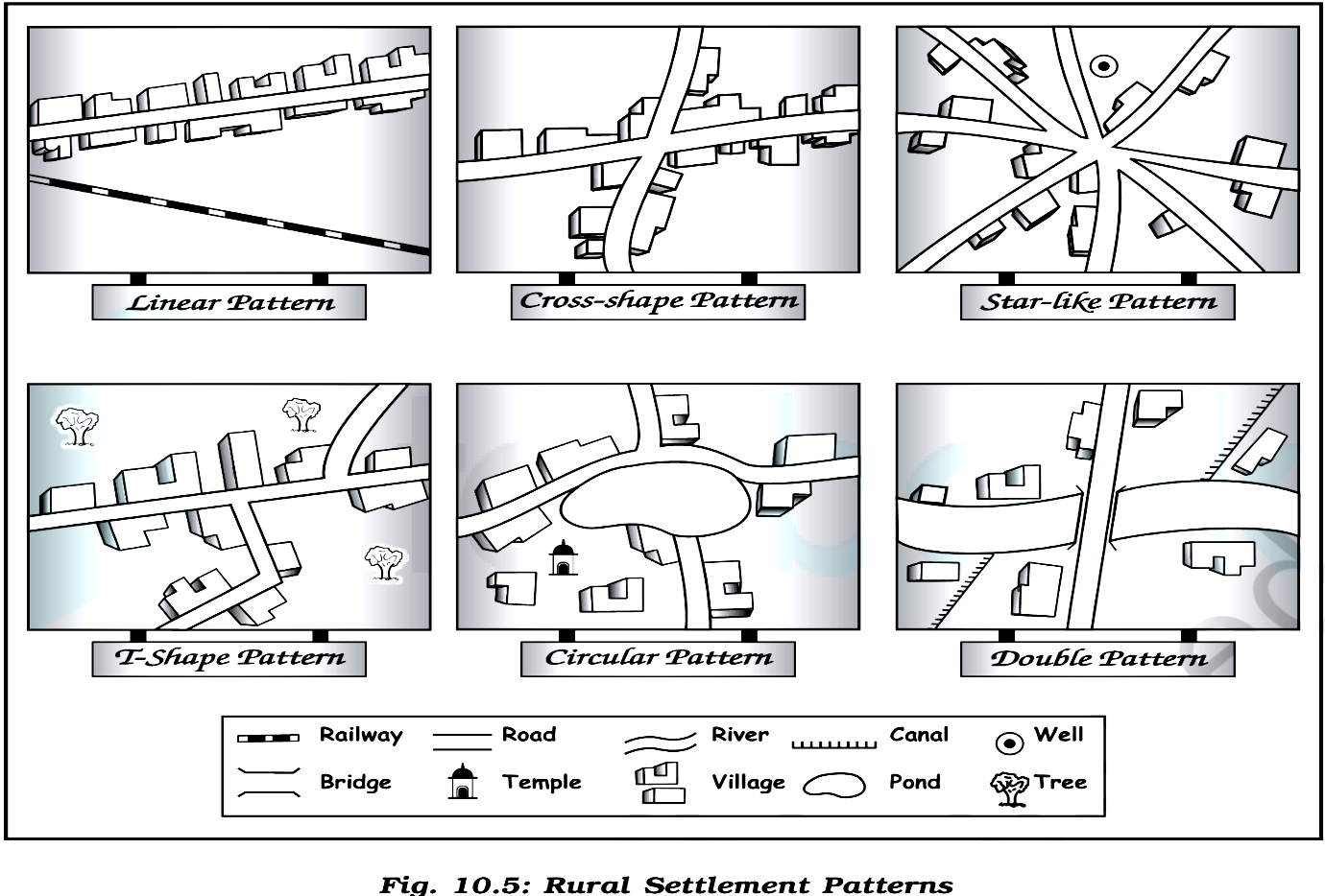
4. Star like pattern
Where several roads converge, star shaped settlements develop by the houses built along the roads.
5. T-shaped, Y-shaped, Cross-shaped or cruciform settlements
T-shaped settlements develop at tri-junctions of the roads while Y-shaped settlements emerge as the places where two roads converge on the third one and houses are built along these roads.
Cruciform settlements develop on the cross-roads and houses extend in all the four directions.
-
Question 12
5 / -1
The Lorraine Region of France is famous for:
Solution
The correct answer is Iron and Steel Industry.
Key Points
- Lorraine is famous worldwide for its quiche, macarons, Mirabelle plum, and madeleine.
- It is home to more than 2.3 million inhabitants (Lorrains and Lorraine's).
- For many years, the region was synonymous with coal, iron, and steel industries and was in 1960 the 3rd economical region in France.
Additional Information
- The states like Maharashtra, Gujarat, Tamil Nadu, Uttar Pradesh, Karnataka, Madhya Pradesh, Rajasthan, and West Bengal have a very high degree of concentration of this industry and especially in the three cities of Bombay, Ahmedabad, and Coimbatore.
- It is the leading producer of cotton textile in India.
- The Paper industry is dominated by North American (the United States and Canada), northern Europe (Finland, Sweden, and North-West Russia), and East Asian countries (such as East Siberian Russia, China, Japan, and South Korea).
- Austral, Asia, and Brazil also have significant pulp and paper enterprises.
- The industry also has a significant presence in a number of European countries including Germany, Portugal, Italy, the Netherlands, and Poland.
- The United States had been the world's leading producer of paper until it was overtaken by China in 2009.
- In India, Gujarat was the largest state contributor to the chemical industry of India in 2018.
- India also produces products related to petrochemicals, fertilizers, paints, varnishes, glass, perfumes, toiletries, pharmaceuticals, etc.
- The Indian chemical industry is divided into six sub-segments.
-
Question 13
5 / -1
Which one of the following is non-renewable source of energy?
Solution
The correct answer is Thermal.
Key Points
Thermal Energy:
- Fossil fuels, coal and biomass are the major sources of thermal energy.
- These sources will end after a short time.
- This source of energy is not recycled and reused.
- While hydroelectricity, wind energy and solar energy are renewable sources of energy.
Thus, thermal is a non-renewable source of energy.Additional Information
ally two sources of energy:There are basic
Renewable resources or Non-Conventional | Non-Renewable resources or Conventional |
The resources can renew themselves or can be used again and again. | The sources cannot be replaced or reused once they are destroyed. |
Renewable resources are replenished naturally and over relatively short periods of time. It is present in unlimited quantity | These are limited resources and consume millions of years to make. So these are used limitedly. |
It has low carbon emission and is hence is environment friendly. | These are not environmentally friendly because the amount of carbon emission is high. |
The cost is low. | The cost of these resources is high. |
A large land area is required for the installation of these plants. | Less land requirement of installation of these plants. |
They require high maintenance costs. | They require low maintenance costs. |
Example: soil, water bodies, sun (solar energy), wind, tidal energy, atomic energy, geothermal, forest, mountains, wildlife, atmospheric resources. | Example: coal, oil, nuclear energy, petroleum, natural gas, LPG, batteries, shale gas, soil and phosphate are some examples. |
-
Question 14
5 / -1
The earliest Iron and Steel Company to be established in India was:
Solution
The correct answer is TISCO.
Key Points
- Tata iron and steel Company
- The first and one of the largest manufacturing plants in Asia is Tata Iron and Steel Company, also known as TISCO.
- Tata iron and steel Company is situated in Jharkhand which was founded by Jamsetji Tata in 1907 and is the oldest steel plant in India. Hence, Option 2 is correct.
- Tata Iron and Steel Company or TISCO is the first iron and steel manufacturing plant in India which was founded and established by Jamsetji Tata and Dorabji Tata respectively on 26th August 1907 at Jamshedpur, Jharkhand.
- Tata iron and steel Company started production of pig iron in the year 1911 and production of steel in the year 1912.
- Tata iron and steel Company made rapid progress during the First World War and by 1939, the largest steel plant was operated by Tata iron and steel Company within the British Empire.
- The establishment of Tata Iron and Steel Company at Jamshedpur includes various advantages like it is near to deposits of coal and manganese, iron ores, and even to Kolkata which provided a large market.
- An adequate water supply is ensured by the rivers Kharkai and Subarnarekha.
- The headquarters of Tata iron and steel company is in Mumbai, Maharashtra and its marketing headquarters are situated in Kolkata and West Bengal.
- Its manufacturing operations are present in 26 countries which include India, Australia, United Kingdom, United Arab Emirates, Malaysia, France, Canada, etc.
- The iron and steel manufactured by Tata iron and steel Company are utilized in construction, automation, engineering, lifting and excavation, defense and security sectors, and many more.
- The first iron and steel plant in India was established at Jamshedpur city in Jharkhand state.
-
Question 15
5 / -1
Regional planning relates to :
Solution
The correct answer is Option 2.
Key Points
- Regional Planning aims at the holistic development of a region.
- It is a specific type of planning which is based on a specific planning structure for inducing public action aimed at societal well being.
- The basic goals of Regional Planning are:
- Building the resource base of an economy
- Diversifying the national economy
- Providing strength and balance in the economic development of the nation,
- Environmental improvement and protection
- The general welfare of the people
- It strives to develop as a broad base of regional economic activities so that the natural and human resources can be economically sustained.
- Regional Planning does not work for regional self-sufficiency but for balanced and harmonious national development.
- Hence, option 2 is correct.
-
Question 16
5 / -1
Which of the following industries is not a heavy industry?
Solution
The industry is a category of active enterprises and organizations which produce or sell products, services, or sources of revenue. Industries are commonly categorized in economics as the primary industry, secondary industry and tertiary industry.
 Important Points
Types of the industry:
Secondary Industry- This industry sector(manufacturing industry) processes the raw materials supplied by primary industries and transforms them into consumer products. Further procedures products that have been incorporated into product lines by specific secondary industries. Develops capital equipment used to produce customer and non-consumer products. The sector is further divided into,
Large or heavy scale industry – It involves massive investment capital in plants and equipment, provides a vast and varied industry such as other industrial sectors, has a complex industrial organization and often a skilled specialist workforce, and produces a high quantity of production.
- Small or light scale industry – It may be distinguished by the nondurability of industrial products and a limited cost of capital in plant and machinery, which may include nonstandard items, such as personalized or design work.
Thus, it is clear that the Cotton textile industry is not heavy industry.
Additional Information
- Primary Industry- The field of the economy of a nation comprises forestry, agriculture, fishing, quarrying, mining and mineral extraction. It could be categorized into two types.
- Tertiary Industry- In the tertiary industry sector, also known as the service industry, involves sectors that provide services or economic costs or produce wealth while generating no tangible goods. In the free market and mixed economies, such a sector typically has a mixture of government and private companies.
- Examples – Real estate service, banking and finance service, communication services etc.
-
Question 17
5 / -1
Which one of the following is the most busy navigable river?
Solution
The correct answer is the Rhine.
- The Rhine is the most important and busiest waterway in Europe.
Key Points
- Navigable rivers:
- Rivers that are deep, wide, perennial, and free of any obstruction are known as navigable rivers.
- In navigable rivers, boats can move heavy goods from one location to another and transport them.
 Important Points
- The Rhine waterways are significant in the following ways:
- With more than 20,000 ocean-going ships and 2,00,000 inland vessels exchanging their cargo on this route, it is the world's most widely used waterway.
- This stretch of the waterway is pushed by immense tonnage.
- From Rotterdam in the Netherlands to Basel in Switzerland, the Rhine river is navigable for 700 km.
- It flows through a rich coalfield that has made the entire region a prosperous area of development.
- The waterway connects the industrial zones of Germany, France, Switzerland, Belgium, the Netherlands with North Atlantic sea routes.
Rhine river of Europe
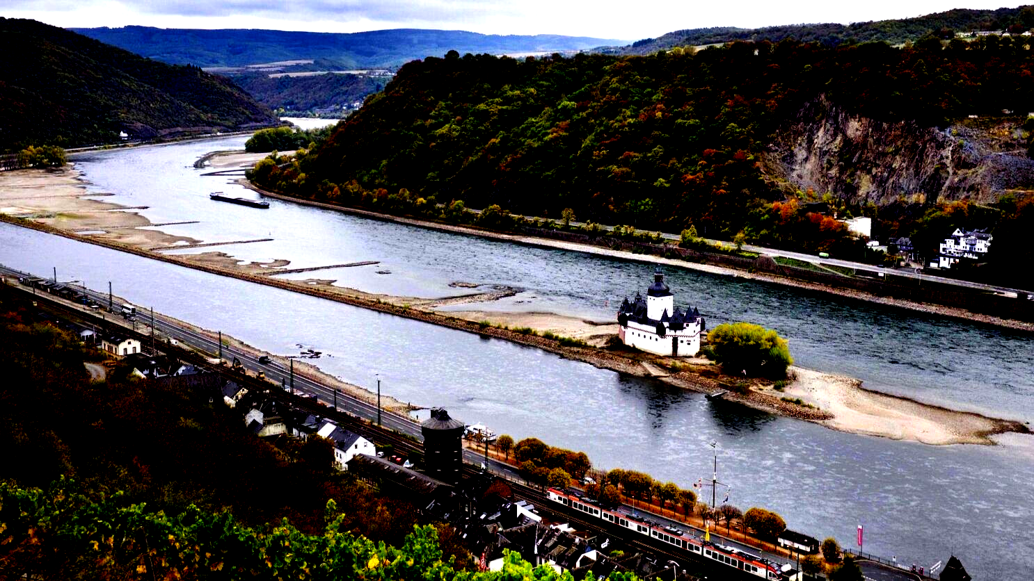
Additional Information
- Ganga and Brahmaputra are two navigable rivers in India.
- Other busy waterways include the French Seine and Loire Rivers, the Eastern European Danube River, and Russia's Volga River.
-
Question 18
5 / -1
What do you understand by Sex ratio?
Solution
The ratio between the number of women and men in the population per 1000 is called the Sex Ratio.
- The sex ratio is an important information about the status of women in a country.
- In regions where gender discrimination is rampant, the sex ratio is bound to be unfavourable to women.
-
Question 19
5 / -1
Match List I and List II and choose the correct answer from the codes given below.
| List I | List II |
| A. Extraction of raw materials | I. Quertarnery sector |
| B. Transformation of raw material into goods | II. Primary sector |
| C. Providing valuable services | III. Secondary sector |
| D. Using knowledge for creating new things | IV. Tertiary sector |
Solution
The correct answer is Primary sector
Key Points
The three-sector theory was developed by Allan Fisher, Colin Clark, and Jean Fourastié
Sector of economy | Nature of activity | Examples |
Primary | Extraction of raw materials | Hunting and gathering, pastoral activities, fishing, forestry, agriculture, and mining and quarrying. |
Secondary | Manufacturing | Manufacturing processing and construction (infrastructure) industries. |
Tertiary | Services | Trade and commerce, retail trading services, communication services |
 Important Points
Other sectors
Quaternary | Knowledge Sector | tax consultants, software developers, and statisticians |
Quinary | creation, re-arrangement, and interpretation of new and existing ideas | senior business executives, government officials, research scientists, financial and legal consultants |
-
Question 20
5 / -1
Which of the following canals is used as an inland waterway in Southern Germany ?
Solution
The correct answer is Ludwig's canal.
Key Points
The Ludwig canals are used as an inland waterway in Southern Germany.
- The canal linked the Danube River at Kelheim with the Main River at Bamberg, connecting the Danube basin with the Rhine basin.
- The first realisation of a dream to enable barges to navigate from the North Sea to the Black sea.
- The Ludwig Canal proved to be unsustainable and was eventually succeeded by a larger canal, over a century later.
- Today, there still exists between Nuremberg and Berching some 60 km of the canal in good condition.
- Some of the locks still function, and part of the towpath has been converted to a cycle track.
- The old canal comes close to the new canal at Pollanten, and from there the two canals flow downstream in parallel, eventually meeting 5km south of Berching.
- Hence, option 3 is correct.
Additional Information
White sea Canal :
- The White Sea is a southern inlet of the Barents Sea.
- It is on the northwest coast of Russia.
- It is surrounded by Karelia to the west, the Kola Peninsula to the north, and the Kanin Peninsula to the northeast.
- All of the White Sea is under Russian control and considered to be part of the internal waters of Russia.
Volga-Don Canal :
- Lenin Volga–Don Shipping Canal is a broad ship canal that connects the Volga and the Don at their closest points.
- The canal forms a part of the Unified Deep Water System of European Russia.
Sault-Sainte Marie Canal :
- Sault Sainte Marie Canal National Historic Site, with the international bridge in the background, Canada.
- The canal was designated a National Historic Site in 1987 and is managed by Parks Canada as a unit of the national park system.
- It welcomes recreational boating and land-based visitors.
- Another unique feature of the site is the Sault Canal Emergency Swing Dam, the only emergency swing dam left in existence, and the only one to ever be used in an emergency.
-
Question 21
5 / -1
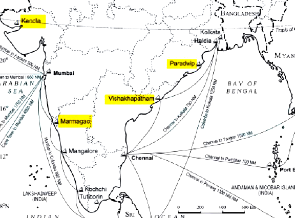
Which one of the following is a land locked harbour?
Solution
The correct answer is Vishakhapatnam.
Key Points
- There are currently 13 major seaports in India, out of which 12 are operated under the government of India while one is run by a corporation (Ennore Port). These seaports are crucial to sustaining and improving India's developing economy.
- Vishakhapatnam - AP
- It is situated in Andhra Pradesh is a land-locked harbour, connected to the sea by a channel cut through solid rock and sand.
- An outer harbour has been developed for handling iron ore, petroleum, and general cargo.
- Andhra Pradesh and Telangana are the main hinterlands for this port.
- Kandla - Gujarat
- It is situated at the head of the Gulf of Kuchchh has been developed as a major port to cater to the needs of western and northwestern parts of the country and also to reduce the pressure at Mumbai port.
- Paradip - Orissa
- It is situated in the Mahanadi delta, about 100 km from Cuttack.
- It has the deepest harbour especially suited to handle very large vessels.
- Marmagao - Goa
- It is situated at the entrance of the Zuari estuary, is a natural harbour in Goa.
-
Question 22
5 / -1
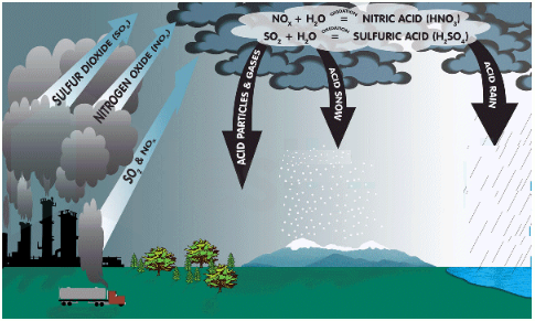
Which one of the following is the cause of acid rain?
Solution
The correct answer is Air Pollution.
Key Points
- Acid rain is rain that has been made acidic by certain pollutants in the air.
- It is caused by a chemical reaction that begins when compounds like sulfur dioxide and nitrogen oxides are released into the air.
- These substances can rise very high into the atmosphere, where they mix and react with water, oxygen, and other chemicals to form more acidic pollutants, and ultimately falls with rain.
- Effects:
- It depletes all nutrients which are required for the growth and survival of plants.
- It alters the composition of the soil, ultimately reducing the crop yield.
- It causes respiratory issues in animals and humans.
- It affects the aquatic ecosystem by altering the chemical composition of the water.
- It corrodes the buildings and monuments made up of stones and metals.
-
Question 23
5 / -1
Push and pull factors are responsible for–
Solution
The correct answer is Migration.
Key Points
- Migration is the movement of humans from one place to another.
- It occurs when the perceived interaction of Push and Pull factors overcome the friction of moving.
- Push factors: Elements of the origin place that are invoked a desire to leave in people.
- e.g: Lack of services, Lack of safety, High crime, Crop failure etc.
- Pull factors: Elements of the destination that are attracting people.
- e.g: Higher employment, More wealth, Better services etc.
- Here, the friction of moving may be costs in time, finance and emotions in leaving one location and moving to another.
-
Question 24
5 / -1
On which river and between which two places does the National Water Way No. 1 lie?
Solution
The correct answer is Option 2.
Key Points
- India has about 14500 km of navigable waterways including rivers, backwaters, canals etc.
- In 1986, the Government of India created the Inland Waterways Authority of India (IWAI) for the regulation and development of Inland Waterways for navigation and shipping.
- In March 2016, the National Waterways Act, 2016 was enacted.
- It created 106 new waterways on rivers, estuaries, creeks, backwaters and canals in the country.
- Currently, 13 NWs are operational for shipping and navigation and cargo/passenger vessels are moving on them.
- NW – 1 is on the Ganga-Bhagirathi-Hooghly river from Prayagraj to Haldia having a length of 1620km stretching in Uttar Pradesh, Bihar, Jharkhand, West Bengal. Hence, option 2 is correct.
Additional Information - NW - 2 is on the Brahmaputra river from Sadiya to Dhubri having a length of 891 km in Assam.
- NW - 3 is on West Coast Canal, Champakara Canal, and Udyogamandal Canal from Kottapuram to Kollam having a length of 205 km in Kerala.
- NW - 8 is on Alappuzha- Changanassery Canal having a length of 28 km in Kerala.
-
Question 25
5 / -1
Shifting Cultivation is practiced in which of the following states?
Solution
Agriculture has been practised since ancient times.
- Cultivation methods have changed significantly over these years depending upon the Physical environment, Technological advancement and socio-cultural practices.
- There are two types of farming- Subsistence farming, and Commercial farming.
 Important Points
Subsistence farming is when a farmer cultivates enough to feed his family. Farmers cultivate their land by using low levels of technology, and household labour. This farming is further divided into Primitive farming and Intensive subsistence farming.
- Primitive subsistence farming includes Shifting cultivation and nomadic herding.
- In Shifting cultivation, a plot of land is cleared so that food crops are grown to sustain the family needs.
- When soil loses fertility farmers move to new land for cultivation.
- Shifting cultivation is also known as slash and burn agriculture.
- In the north-eastern states, it is known as Jhum or Jhoom cultivation.
- It is practised by the tribal groups in the north-eastern states of India like Arunachal Pradesh, Meghalaya, Mizoram and Nagaland and also in the districts of Bangladesh like Khagrachari and Sylhet.
Thus, we can conclude that Shifting Cultivation is practised in the North-eastern states of India.
-
Question 26
5 / -1
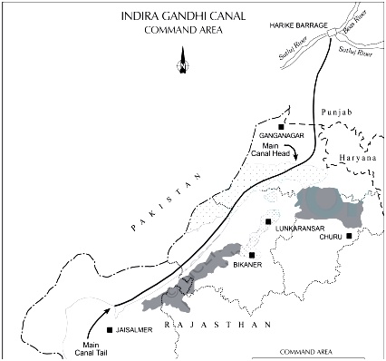
Which one of the following is the most crucial factor for sustainable development in Indira Gandhi Canal Command Area?
Solution
The correct answer is Eco-development.
Key Points
- Indira Gandhi Canal is one of the largest canal systems in India.
- Launched on 31st March 1958.
- It originates at Harike barrage in Punjab and runs parallel to the Pakistan border at an average distance of 40 km in the Thar Desert of Rajasthan.
- It fulfils irrigation needs of a total culturable command area of 19.63 lakh hectares.
- Attaining sustainable development in the command area requires major thrust upon the measures to achieve ecological sustainability.
- Most of the measures proposed to promote sustainable development in the command area are meant to restore ecological balance. Hence, option 2 is correct.
- Measures are:
- Strict implementation of water management policy
- The cropping pattern shall not include water-intensive crops
- The areas affected by waterlogging and soil salinity shall be reclaimed
- Eco-development through afforestation, shelterbelt plantation and pasture development
- Adequate financial and institutional support for the cultivation of land etc.
-
Question 27
5 / -1
Which one of the following best describes development?
Solution
The correct answer is a positive change in quality.
Key Points
- Development:
- Development means a qualitative change that is always value positive.
- This means that development cannot take place unless there is an increment or addition to the existing conditions.
- Development occurs when positive growth takes place.
- Yet, positive growth does not always lead to development.
- Development occurs when there is a positive change in quality. Hence option 3 is correct.
-
Question 28
5 / -1
Which one of the following is not a plantation crop?
Solution
The correct answer is Wheat.
- Plantation crops are those crops that are cultivated on an extensive scale, owned, and managed by an individual or a company. Plantations provide a high level of productivity and employment.
 Important Points
Coffee is a tropical plantation crop.
- Its seeds are roasted, and ground, and are used for preparing a beverage.
- There are three varieties of coffee i.e. arabica, robusta, and Liberia.
- India mostly grows superior quality coffee, arabica, which is in great demand in the international market.
- Coffee is cultivated in the highlands of western ghats in Karnataka, Kerala, and Tamil Nadu.
- Karnataka alone produces two-third of the total production of coffee in the country.
Additional Information
Lets' look at the other given options:
- Jute is a fiber crop. It is a type of Kharif crop. These crops provide us with fiber for preparing cloth, bags, sacks, and a number of other items.
- Wheat is the second most important cereal crop in India after rice. Its cultivation is done in India during winter i.e. Rabi season.
- Sugarcane is a crop of tropical areas. It is also a type of Kharif crop. It is cultivated in sub-humid and humid climates.
-
Question 29
5 / -1
Transportation cost does not play a major role in the location of textile industry, because
Solution
Transportation cost does not play a major role in the location of textile industry, because weight of cotton is more or less equal to the weight of the finished product. There is not much of difference between the cost of transporting raw cotton and finished cloth. Both can be transported with equal ease and without adding much to the total cost of production, it is primarily a market oriented industry.
 Important Points
Factors Affecting the location of Cotton Textile Industry
- Raw Material: It is an agro-based industry and variability in the supply of raw cotton affects the production, there it requires constant supply of raw material. Historically these industries were located close to raw material sources but development in the transport facilities has enabled their spread to other areas.
- Labour: It is a labour-intensive industry and requires cheap labour. It is an important source of employment to large number of population in the country. India enjoys critical advantage over China due to low labour cost in textile sector.
- Climate: Cotton requires black soil as well as hot and humid climate. Cotton yarn cannot be spun successfully under dry conditions. The humidity of the atmosphere must be considerable; otherwise the yarn breaks constantly during the process of spinning.
- Power: It requires a constant and cheap source of power for running powerlooms and textile machines. Earlier, these industries were located close to coal mines areas for cheap and continuous power supply.
- Markets: Availability of domestic and foriegn market for consumption plays a driving force for cotton industries.
-
Question 30
5 / -1
Which is not a correct match?
Shifting Agriculture | Country/Area |
A) Milpa | Mexico |
B) Jhuming | North-East India |
C) Roca | Brazil |
D) Ladang | Sri Lanka |
Solution
Under Shifting cultivation, a piece of land is used for quite some years until the fertility is dropped. After that, the farmers move to the new plots. It is practiced by tribal and is also known as Burn and Slash cultivation.
- It is known as Jhoom in Assam, Bewar in Madhya Pradesh, Onam in Kerala, Podu in Andhra Pradesh, and Odisha.
Over a large part of North East India shifting cultivation used, while having different local names are found to be the same-named as Jhoom cultivation. Jhoom cultivation, also known as Slash-and-Burn cultivation.
Key Features of Shifting Cultivation:-
- They use fire for clearing the land
- They use the land for regeneration for a number of years
- Using human labor as the main input
- Non-employment of draught animals
- Non-use of the plough, but instead very crude and simple implements such as dibble sticks and scrapers

Other Names of Shifting Cultivation:
- Shifting Cultivation is known as Ladang in Indonesia,
- Caingin in the Philippines,
- Milpa in Central America & Mexico,
- Ray in Vietnam,
- Taungya in Myanmar,
- Tamrai in Thailand,
- Chena in Sri Lanka,
- Conuco in Venezuela,
- Roca in Brazil,
- Masole in central Africa.
Hence, from the above-mentioned points, it becomes clear that Ladang shifting cultivation is in Indonesia not in Sri Lanka.
-
Question 31
5 / -1
Which of the following are effects of over-irrigation and poor drainage?
I. Waterlogging
II. Soil salinization
III. Water tables rising artificially
IV. Preventing plant roots from getting adequate oxygen
Solution
The correct answer is I, II, III and IV.
Key Points
- Waterlogging is simply the saturation of soil with water, either temporarily or permanently.
- The soil ought to absorb the water on the surface and regain its natural state.
- The soil is either unable to do that, or human activity makes it difficult for groundwater to go anywhere.
- It leads to a condition referred to as waterlogging, where the land is soaked up and water just rises up.
- The soil might become waterlogged and fail to dry up.
Additional Information
- Soil salinization
- Soil salinization involves a combination of processes like evaporation, salt precipitation and dissolution, salt transport, and ion exchange etc.
- The salt-affected soils contain excessive concentrations of either soluble salts or exchangeable sodium or both to inadequate leaching of base-forming cations.
- The major soil salinity effect on plant growth is tampering with water absorption.
-
Question 32
5 / -1
Which one of the following scholars introduced the concept of Human Development?
Solution
The correct answer is Dr Mahabub-ul-Haq.
Key Points
- The concept of human development was introduced by Pakistani economist Dr Mahbub-ul-Haq. Hence option 2 is correct.
- Dr Haq has described human development as development that enlarges people’s choices and improves their lives.
- He also created the Human Development Index in 1990.
- According to him, development is all about enlarging people’s choices to lead long, healthy lives with dignity.
- The United Nations Development Programme has used its concept of human development to publishing the Human Development Report annually since 1990.
-
Question 33
5 / -1
Mulching is a method of
Solution
Mulching is a method of soil conservation.
Key PointsMulching
- A layer of organic matter like straw covers the bare ground between plants and helps to maintain soil moisture.
- Mulching is a layer of organic material of hay and grass particles that is placed on the surface of the soil to conserve moisture in the soil. It is used to improve the soil around the plants.
- It reduces evaporation rates and conserves soil moisture. It protects the soil from erosion.
- It holds down weeds which helps to improve the soil structure and fertility.
Additional Information
Some soil conservation methods
- Mulching
- A layer of organic matter like straw covers the bare ground between plants and helps to maintain soil moisture.
- Contour barriers
- To create barriers along contours, stones, grass, the soil is being used.
- Trenches are made to collect water in front of the barriers.
- Rock dam
- Rocks are stacked up to slow down water flow and also help to stop gullies and further erosion of soil.
- Terrace farming
- On the steep slopes, wide flat steps or terraces are designed so that flat surfaces are used for cultivation.
- Thus minimizing surface run-off and soil erosion.
- Intercropping
- Various crops can be grown in alternating rows and are planted at varying times to protect the soil from rain washing.
- Ploughing of contours
- Ploughing parallel to the contours of a hill slope to create a natural obstacle for fluid to drain down the slope.
- Shelterbelts
- In the coastal and dry areas, rows of trees are cultivated to track the passage of air and preserve the cover of the soil.
-
Question 34
5 / -1
In which one of the following countries co-operative farming was the most successful experiment?
Solution

Co-operative farming:
- Cooperative farming means that each farmer will remain the owner of the land but farming is done together.
- It means that farming runs in cooperation with each other.
- That means purchasing of farm materials and using machines etc. are done collectively and profit is distributed among all the farmers who are the members depending on the ratio of land owned by them.
- It improves the quality of products and services and reduces the risk for the farmers.
- It has been very successful in Denmark so there it is practised on a large scale.
Thus, in Denmark co-operative farming was the most successful experiment.
-
Question 35
5 / -1
Given below are two statements - one is labelled as Assertion (A) and the other is labelled as Reason (R).
Assertion (A): Most of the developing countries in the world have progressive population
Reason (R): The developing countries recorded declining fertility rate and high mortality rate
Select the correct answer from options given below:
Solution
The age-sex structure of a population refers to the number of females and males in different age groups. A population pyramid is used to show the age-sex structure of the population. There are 3 basic age structures:
- Progressive (Brazilian) Type
- Stationery (American) Type
- Regressive (European) Type

Progressive (Brazilian) Type
- It has a wide base that quickly narrows upwards to a point.
- It indicates a large birth rate, but poor conditions mean people rapidly die-off
- Hence the triangular shape of the structure.
- The population is increasing
- Most of the developing countries in the world have a progressive population.
Stationery (American) Type
- The shape of this structure is more "square." All age groups are well represented.
- It indicates that the birth rate is moderate, and few people die off as they get older.
- The population is stagnant
Regressive (European) Type
- The structure has a fairly wide top with a bulging middle and narrow base.
- The birth rate is low, hence the low base, and there are more adults than children.
- The population is decreasing.
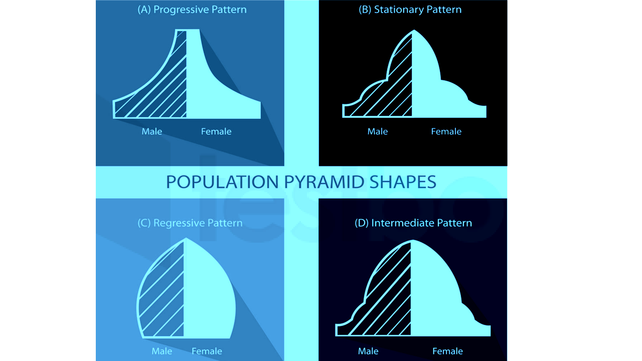
Hence, (A) is true, but (R) is false.

| Progressive Population | Regressive Population |
| The progressive population is where the death rate and birth rate are high. | The regressive population has a low death rate and a declining birth rate. |
| The age-sex pyramid shows a wide base and rapid tapering apex. | The age-sex pyramid has a narrow base and narrow top. |
| Life expectancy is low. | Life expectancy is high. |
| The progressive population is found in less developing countries passing through the first stage of demographic transition. | Developed countries such as Sweden, France, Germany are good examples of regressive population. |
-
Question 36
5 / -1
Which one of the following is the second largest producer of sugarcane?
Solution
The correct answer is Maharashtra.
Key Points
- As per the National Horticulture Board report 2019-2020, Uttar Pradesh is the largest producer of sugarcane crops (36% of total sugarcane production in India).
- While Maharashtra is the second-largest producer of sugarcane in India (32% of total sugarcane production in India).
- Factors for the growth of Sugarcane:
- Hot and moist climate.
- A long frost-free growing season.
- Average annual rainfall: Between 100 cm and 150 cm.
- Deep, well-drained, rich loamy soil is ideal for its growth.
- Bright sunshine after rainfall increases the juice content in sugar cane.
- The sugarcane productivity and juice quality are profoundly influenced by weather conditions.
- Conditions favouring high sugar accumulation are:
- Dry weather with low humidity; bright sunshine hours, cooler nights and very little rainfall during the ripening period.
-
Question 37
5 / -1
Which one of the following river is highly polluted?
Solution
The correct answer is the Yamuna.
Key Points
- The Yamuna is one of the most polluted rivers not only in North India but in the entire country.
- It originates from the Yamunotri glacier, Uttarkashi, Uttarakhand.
- The length of the river is 1370 Km.
- It meets the river Ganga in Prayagraj, Uttar Pradesh.
- Many major cities such as Agra, Mathura, Delhi are situated on its bank.
- The people and industries in the national capital treat this sacred river as a dumping yard.
- The reason behind its pollution:
- More than 50% of the total waste of Delhi is thrown into the Yamuna.
- High phosphate content in the wastewater because of detergents used in dyeing industries, dhobi ghats and households causes the formation of toxic foam.
- The pesticides used in the agricultural land nearby the river directly contributes to the pollution of Yamuna.
- The government is running a “Yamuna Action Plan” to clean the Yamuna, with a total cost of Rs. 1665 Cr.
-
Question 38
5 / -1
Most of India’s foreign trade is carried through
Solution
The correct answer is Sea and air.
Key Points
- India is surrounded by water on three sides and has a coastline of 7516.6 km.
- This geographical feature has made sea transport the major player in carrying out the international trade of India.
- Most of India’s foreign trade is carried through sea and air routes.
- However, a small portion is also carried through land routes to neighbouring countries like Nepal, Bhutan, Bangladesh and Pakistan.
- According to the Ministry of Shipping, around 95% of India's trading by volume and 70% by value is done through maritime transport.
- However, sea alone is not sufficient to transport India’s exports, which include perishable materials which can only be transported through the air.
- Although the demand for air freight is limited by cost so, cargo shipped by air has high values per unit and are very time-sensitive.
- The air cargo sector is known to be the barometer of the economic health of a country because of the cost factor.
Additional Information
- Major sea trading ports of India:
- Kandla Port, Mumbai Port, Chennai Port, Kolkata Port, Cochin Port, Vizag port etc.

-
Question 39
5 / -1
Match List - I with List - II and select the correct answer using the code given below :
List-I (Whiltlesey’s Agriculture Religions) | List-II (Name of Countries) |
A. Commercial Dairy Farming | 1. Argentina |
B. Commercial Grain Farming | 2. Sri Lanka |
C. Nomadic Herding | 3. New Zealand |
D. Commercial Plantations | 4. Mongolia |
Solution
Key Points Whiltlesey’s Agriculture Religions | Name of Countries |
A. Commercial Dairy Farming | 3. New Zealand |
B. Commercial Grain Farming | 1. Argentina |
C. Nomadic Herding | 4. Mongolia |
D. Commercial Plantations | 2. Sri Lanka |
Hence, the correct matching is A - 3, B - 1, C - 4, D - 2
 Important Points
Whiltlesey’s Agriculture Religions | Characteristics |
A. Commercial Dairy Farming | - New Zealand – in a nutshell, it is one of the most profitable dairy farming sectors and the lowest-cost producers globally.
- Dairy farming is a big business in New Zealand and it is New Zealand's top export earner.
|
B. Commercial Grain Farming | - The major countries where commercial grain farming has successfully developed are U.S.A. and Canada in N. America; Argentina in S. America; Australia and New Zealand in Oceania and Ukraine, Russia, Germany, France, Netherlands, etc. in Europe.
|
C. Nomadic Herding | - Nomadic herders live in Mongolia, tending herds of sheep, goats, camels, yaks, and horses just as their ancestors have for more than 3,000 years.
- Herder families live in canvas wool tents called a ger.
- To erect a ger, a canvas covering is draped over a frame of wooden supports, like the spokes of a bicycle wheel.
|
D. Commercial Plantations | - Sri Lanka's primary food crop is rice.
- Rice is cultivated during two seasons.
- Tea is cultivated in the central highlands and is a major source of foreign exchange.
- Fruit, vegetables, and oilseed crops are also cultivated in the country.
|
-
Question 40
5 / -1
Trade between two countries is termed as
Solution
The correct answer is International trade.
Key Points
- International trade is the exchange of goods and services between countries. Hence, option 2 is correct.
- It is done through air, sea or land route.
- Through international trade, buyers find the markets in the foreign and sellers find a new market to sell.
- It allows countries to expand their markets and access goods and services that are otherwise may not have been available domestically.
- It helps countries in terms of tax incentives, support training initiatives to develop the national advantage.
- The WTO is an international organization authorised to supervise and adjudicate international trade.
- Currently, China is the top trading partner of India.
- The two-way trade between India and China stood at USD 77.7 billion for the year 2020.
-
Question 41
5 / -1
In which of the following year, the first radio programme was broadcast?
Solution
The correct answer is 1923.
Key Points
- Marconi started radio broadcasting in 1896 with the invention of the first wireless telegraph link.
- Chronology of Radio broadcast in India:
- Radio broadcasting in India began as a private venture in 1923 and 1924, with the establishment of three radio clubs i.e: in Bombay, Calcutta and Madras.
- The Radio Club of Bombay broadcast the first radio programme in India in June 1923. Hence, option 3 is correct.
- The Indian Broadcasting Company (IBC) came into being on July 23, 1927.
- Lionel Fielden was appointed the first Controller of Broadcasting in August 1935.
- In 1936, a radio station was commissioned in Delhi.
- In 1936, the Indian Broadcasting Service was renamed All India Radio (AIR).
- In 1956, the name AKASHVANI was adopted for the National Broadcaster.
- The Vividh Bharati Service was launched in 1957 with popular film music as its main component.
-
Question 42
5 / -1
Which one of the following is NOT a land-use category?
Solution
The correct answer is Marginal land.
Key Points
- As per the Ministry of Statistics and Program Implementation, Government Of India, the land-use area is classified into the following nine categories:
- Forests: It comprises all lands classed as forest under any legal enactment dealing with forests or administered as forests.
- The area under Non-agricultural Uses: It includes all lands occupied by buildings, roads and railways or underwater.
- Barren and Un-culturable Land: It consists of all barren and unculturable land like mountains, deserts, etc.
- Permanent Pastures and other Grazing Lands: It includes all grazing lands whether they are permanent pastures and meadows or not.
- Land under Miscellaneous Tree Crops, etc.: It includes all cultivable land that is not included in ‘Net area sown’ but is put to some agricultural uses.
- Culturable Waste Land: It comprises lands available for cultivation, whether not taken up for cultivation or taken up for cultivation once but not cultivated during the current year
- Fallow Lands other than Current Fallows: It comprises all lands, which were taken up for cultivation but are temporarily out of cultivation for a period of not less than one year and not more than five years.
- Current Fallows: It represents cropped areas, which is kept fallow during the current year.
- Net sown area: It represents the total area sown with crops and orchards.
- There is not any category like Marginal lands. Hence, Option 3 is correct.
-
Question 43
5 / -1
Which of the following statements about subsistence farming is incorrect?
Solution
The correct answer is Modern and high-end technology is used in this kind of farming.
- Modern and high-end technology is used in this kind of farming.
Key Points
- Subsistence Farming:
- It is characterised by small and scattered land holdings and the use of primitive tools. Hence, option 4 is incorrect.
- As the farmers are poor, they do not use fertilisers and high yielding variety of seeds in their fields to the extent they should do.
- Shifting cultivation is a type/ example of subsistence farming in which the farmers clear a patch of forest land by cutting and burning trees and then crops are grown.
- This type of farming is practised to meet the needs of the farmer’s family.
- Traditionally, low levels of technology and household labour are used to produce small output.
- Facilities like electricity and irrigation are generally not available to them.
Additional Information
- In commercial farming, crops are grown and animals are reared for sale in the market.
- The area cultivated and the amount of capital used is large.
- Most of the work is done by machines.
- Extensive and intensive farming:
- In intensive subsistence agriculture, the farmer cultivates a small plot of land using simple tools and more labour.
- Climate with a large number of days with sunshine and fertile soils permit the growing of more than one crop annually on the same plot.
- Rice is the main crop. Other crops include wheat, maize, pulses, and oilseeds.
- Intensive subsistence agriculture is prevalent in the thickly populated areas of the monsoon regions of the south, southeast, and east Asia.
- Primitive subsistence agriculture includes shifting cultivation and nomadic herding.
-
Question 44
5 / -1
Contour cultivation, contour strip-cropping, mixed-cropping and tillage are examples of which of these terminologies?
Solution
The correct answer is Mechanical and agronomic soil and water conservation.
Key Points
- Agronomic conservation measures function by:
- Reducing the impact of raindrops through interception and thus reducing soil erosion.
- Increasing infiltration rates and thereby reducing surface runoff and soil erosion.
- These measures can be applied together with physical or biological soil and water conservation measures.
- In some systems, they may be more effective than structural measures.
- It is the cheapest way of soil and water conservation.
- The differences in erosion rates caused by different land-use practices on the same soil are much greater than the corresponding values from different soils under the same land use.
- Agronomic measures are often more difficult to implement compared with structural ones as they require a change in familiar practices.
Additional Information
- Integrated Pest and nutritional management
- Integrated pest management is a broad-based approach that integrates practices for Organization defines IPM as the careful consideration of all available pest control techniques and subsequent integration of appropriate measures that minimize risks to human health and the environment.
- The introduction and spread of invasive species can also be managed with Integrated Pest Management by reducing risks while maximizing benefits and reducing costs.
- Entomologists and ecologists have urged the adoption of IPM pest control since the 1970s. IPM allows for safer pest control.
- Watershed based management system
- The word watershed introduce in 1920 was used for the water parting boundaries.
- A Watershed is a land area that drains or contributes runoff to a common outlet.
- A Watershed is defined as a geohydrological unit draining to a common point by a system of drains.
- All lands on earth are part of one watershed or another.
- Resource conserving technologies
- Resource conserving technologies refers to those practices or technologies that enhance resources or input use efficiency such as new varieties that use nitrogen more efficiently, zero or reduced tillage practices that save water, etc, which may be considered as RTCs.
-
Question 45
5 / -1
The total number of children born or likely to be born to woman in her lifetime, if she were subject to the prevailing rate of age specific fertility in the population, is known as -
Solution
The correct answer is Total fertility rate
Key Points
- The total fertility rate (also called the fertility rate, absolute/potential natality, period total fertility rate, or total period fertility rate) of a population is the average number of children that would be born to a woman over her lifetime if: she was to experience the exact current age-specific fertility rates through her lifetime she was to live from birth until the end of her reproductive life.
- It is obtained by summing the single-year age-specific rates at a given time.
-
Question 46
5 / -1
Which one of the following countries is the largest producer of uranium in the world?
Solution
The correct answer is Kazakhstan.
Key Points
- Kazakhstan produces the largest share of uranium from mines (42% of world supply from mines in 2019), followed by Canada (13%) and Australia (12%).
- Over two-thirds of the world's production of uranium from mines is from Kazakhstan, Canada, and Australia.
- An increasing amount of uranium, now over 50%, is produced by in situ leachings.
 Important Points
About Uranium:
- Uranium is a very important element because it provides us with nuclear fuel used to produce electricity in nuclear power stations.
- It is also the major material from which other synthetic transuranium elements are made. Naturally occurring uranium consists of 99% uranium-238 and 1% uranium-235.
- Uranium is generally used in reactors in the form of uranium dioxide or uranium metal.
-
Question 47
5 / -1
Which of the following has the least population?
Solution
The correct answer is Australia.
Key Points
- According to the census 2011,Australia has the least population.
Continent | Population (2020) | Area (Km²) | Density (P/Km²) | World Population
Share |
| Asia | 4,641,054,775 | 31,033,131 | 150 | 59.54% |
| Africa | 1,340,598,147 | 29,648,481 | 45 | 17.20% |
| Europe | 747,636,026 | 22,134,900 | 34 | 9.59% |
North America | 592,072,212 | 21,330,000 | 28 | 7.60% |
| South America | 430,759,766 | 17,461,112 | 25 | 5.53% |
| Australia/Oceania | 43,111,704 | 8,486,460 | 5 | 0.55% |
| Antarctica | 0 | 13,720,000 | 0 | 0.00% |
-
Question 48
5 / -1
Which of the following is a technology for utilizing renewable energy sources in tropical countries?
Solution

Solar cooker:
- It is a device that uses the energy of sunlight to heat or cook food
- A concave mirror is a mirror whose reflecting surface is toward the center of the curvature. It is also known as a converging mirror.
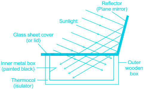
- A solar cooker contains a box made of insulating material, with its inner surfaces blackened. The top is closed by a glass sheet.
- The glass sheet present in the solar cooker easily passes the radiation into the solar cooker and the radiation gets absorbed and cannot pass back out through the glass.
- The technology of utilizing solar energy benefits a lot of tropical countries that are blessed with abundant sunshine.
Due to abandoned resources, i.e. solar energy available in the tropical regions, solar technology can be utilized in a lucid manner.

- A nuclear reactor is a user in nuclear power plants. It is not necessary to be located within the territory of the tropical regions.
- Turbine: A turbine is a device that harnesses the kinetic energy of some fluid - such as water, steam, air, or combustion gases - and turns this into the rotational motion of the device itself.
- A biogas plant is another way of using organic waste and converting them into a gaseous fuel called biogas.
-
Question 49
5 / -1
Which is not a factor of industrial location?
Solution
The correct answer is Population Density.
Key Points
- Population density is not a preferred characteristic for an industrial location as industries tend to be a source of pollution (noise, sound, air, water, and what not!) and, thus, inconvenience for habitats around.
- Industrial location factors
- The industry is classified into different sectors - secondary, tertiary, and quaternary.
- The employment structure of a country shows how the labor force is divided into different sectors.
- Different industries require different inputs.
- Industries are more likely to locate where these inputs are readily and cheaply available.
- Factors that influence where an industry locates include:
- Power supply
- Communications - including transport, telecommunications
- Labour supply - including workers with the right skills
- Access to market - where the goods are sold
- Grants and financial incentives - usually from governments
- Raw materials
- Industrial location favors proximity to market, accessibility of power, and availability of capital.
-
Question 50
5 / -1
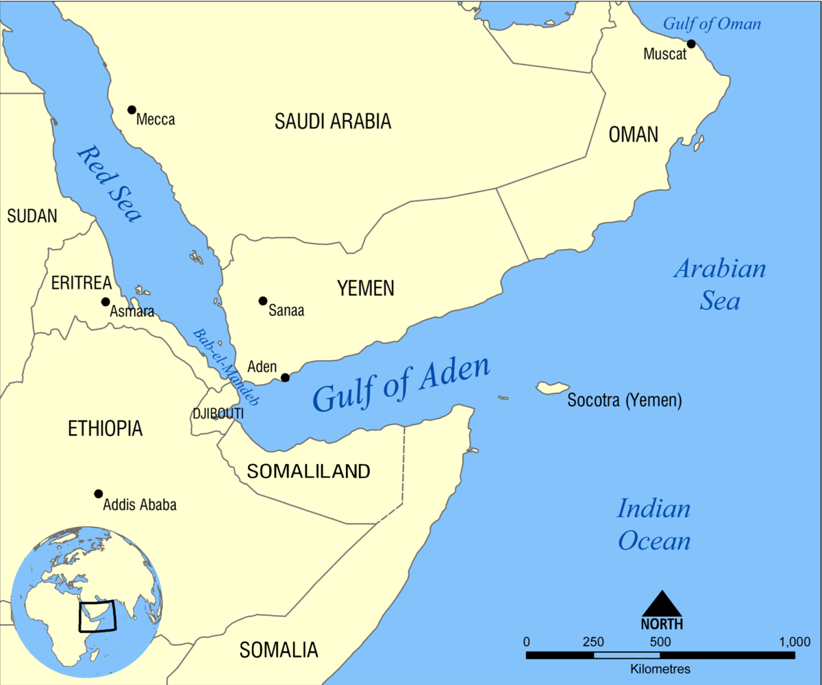
Gulf of Aden is located in ________.
Solution
- The Gulf of Aden is located in the Indian Ocean and is situated between Yemen on the south coast of the Arabian Peninsula and Somalia in Africa.
- The gulf – roughly 900 kilometers long and 500 kilometers wide – is an important waterway for transporting Persian Gulf oil. Together with the Red Sea, which connects within the northwest through the Bab el Mandeb sound, it forms an essential oil transport route between Europe and the Far East.
- The Gulf of Aden, which runs in a west-east direction, and the Red Sea have been used for thousands of years for fishing, trading, and transportation. Located on the great Mediterranean Sea-Indian Ocean trade route, the gulf was a strategic waterway sought by Portugal, Turkey, and Great Britain in the 16th century. Britain prevailed and dominated the gulf by the 19th century.
- When the British military withdrew from the area in the late 1960s, the use of the gulf was diminished due to the closing of the Suez Canal. Egypt renovated and reopened the canal in 1975, boosting activity in the gulf once again.
Additional Information
- In recent years, the gulf has received a lot of attention due to piracy, terrorism, and refugee smuggling. In October 2000, suicide bombers attacked and nearly sank the U.S. destroyer Cole in the gulf, and in 2002 the French oil tanker MIV Limburg, carrying Persian Gulf crude oil, was attacked.
- According to the United Nations High Commissioner for Refugees (UNHCR), 142 people died and another 40 went missing between 12-23 January this year while trying to cross the Gulf of Aden from the Horn of Africa to the coast of Yemen.


 ×
×

 Sign in
 Profile
 Signout