-
Question 1
5 / -1
Nomadic herding or pastoral nomadism comes under which kind of subsistence activity?
Solution
The correct answer is Primitive.
 Key Points
Nomadic Herding
- Nomadic herding or pastoral nomadism is a primitive subsistence activity, in which the herders rely on animals for food, clothing, shelter, tools and transport.
- Hence the correct answer is option 1.
- They move from one place to another along with their livestock, depending on the amount and quality of pastures and water.
- Each nomadic community occupies a well-identified territory as a matter of tradition.
-
Question 2
5 / -1
The Ruhr coalfield is located in which country?
Solution
The correct answer is Germany.
Key Points
The Ruhr Coalfield, Germany
- This has been one of the major industrial regions of Europe for a long time.
- Coal and iron and steel formed the basis of the economy, but as the demand for coal declined, the industry started shrinking.
- Even after the iron ore was exhausted, the industry remained, using imported ore brought by waterways to the Ruhr.
- The Ruhr region is responsible for 80 per cent of Germany’s total steel production.
- This is Germany's most densely populated region.
- The Ruhr coalfield is one of the world's largest, producing the bulk of Germany's bituminous coal.
- Hence the correct answer is option 3.
-
Question 3
5 / -1
A type of farming in which higher doses of modern inputs are used to obtain higher productivity is known as
Solution
Farming varies from subsistence to commercial type. The cultivation methods have changed significantly depending upon the characteristics of the physical environment, technological know-how, and socio-cultural practices.

Commercial Farming:
- The main characteristic of this type of farming is the use of higher doses of modern inputs
- For example, high yielding variety (HYV) seeds, chemical fertilizers, insecticides, and pesticides in order to obtain higher productivity.
- The degree of commercialization of agriculture varies from one region to another.
- For example, rice is a commercial crop in Haryana and Punjab, but in Odisha, it is a subsistence crop.
- The plantation is also a type of commercial farming. In this type of farming, a single crop is grown in a large area.
- The plantation has an interface of agriculture and industry.
- Plantations cover large tracts of land, using capital-intensive inputs, with the help of migrant laborers.
- All the produce is used as raw material in respective industries.
- In India, tea, coffee, rubber, sugarcane, banana, etc.. are important plantation crops.
- Tea in Assam and North Bengal coffee in Karnataka are some of the important plantation crops grown in these states.
Hence, the type of farming in which higher doses of modern inputs are used to obtain higher productivity is known as Commercial Farming.

| Types of farming | Characteristics |
| Extensive Agriculture | - Extensive agriculture, in agricultural economics, is a system of crop cultivation using small amounts of labor and capital in relation to the area of land being farmed.
- The crop yield in extensive agriculture depends primarily on the natural fertility of the soil, the terrain, the climate, and the availability of water.
|
| Shifting Agriculture | - Shifting agriculture is a system of cultivation in which a plot of land is cleared and cultivated for a short period of time, then abandoned and allowed to revert to producing its normal vegetation while the cultivator moves on to another plot.
|
| Subsistence Farming | - The subsistence farming/agriculture etc. farming that produces just enough food for the farmer to live on, but does not produce enough food to sell to other people
|
-
Question 4
5 / -1
The main cause of acid rain is
Solution
The correct answer is- industrial burning of coal and other fossil fuels
 Important Points
- Acid rain means the presence of excessive acids in rainwater.
- The causes of acid rain are Sulfur and Nitrogen particles which get mixed with the wet components of rain.
- Sulfur and Nitrogen particles which get mixed with water are found in two ways either man-made as the emissions are given out from industries or by natural causes.
- Natural causes of acid rain are oxides of sulfur and nitrogen from volcanoes, swamps, and plankton in the oceans.
- However, most of the acids are produced by human activities like power generation from fossil fuels which produces around 70% of the SO2 produced in the atmosphere. However, this is not a natural source but is an anthropogenic source.
Hence, The main cause of acid rain is industrial burning of coal and other fossil fuels Additional Information
Sources of acid rain-
- Sulfur-
- Seas and oceans
- Volcanic eruptions
- Biological processes in the soil
- Burning of coal
- Petroleum product
- Industries
- Nitrogen-
- Lightening
- Volcanic eruptions
- Biological activity
- Forest fires
- Combustion of oil and coal
- Formic Acid-
- Biomass burning due to forest fires causes the emission of formic acid (HCOOH) and formaldehyde (HCHO) into the atmosphere.
- A large fraction of formaldehyde gets photo-oxidation and forms formic acid in the atmosphere.
- The above mentioned three components are the main compound that causes acidification of rain in the atmosphere.
-
Question 5
5 / -1
Which one of the following groups of cities has been arranged in the sequence of their ranks i.e. 1, 2, 3 and 4 in decreasing order of their size according to the population?
Solution
The correct answer is Greater Mumbai, Kolkata, Delhi, Chennai.
Key Points
- Greater Mumbai, Kolkata, Delhi, Chennai' are a group of cities arranged in the 'sequence of their ranks' in size. Hence, Option 4 is correct.
- Greater Mumbai, Kolkata, Delhi, Chennai cities have been arranged in the 'sequence of their ranks'. It has a population of 16.4 million, 13.22 million, 12.79 million, and 6.42 million respectively.
- India is the 'seventh biggest country in the nation by region, and a country this big has a population to match.
- In detail, the country has an entire 39 cities, which has a population of one million residents.

- Greater Mumbai extends from Colaba in the south to Mulund, Mankhurd, and Dahisar in the north, and is under the jurisdiction of Municipal Corporation Greater Mumbai.
- Greater Mumbai forms two districts of Maharashtra, each under the jurisdiction of a District Collector.
- Kolkata (formerly Calcutta) is the capital of India's West Bengal state.
- Founded as an East India Company trading post, it was India's capital under the British Raj from 1773 - 1911.
- Today it’s known for its grand colonial architecture, art galleries, and cultural festivals.
- It’s also home to Mother House, headquarters of the Missionaries of Charity, founded by Mother Teresa, whose tomb is on site.
- Delhi, India’s capital territory, is a massive metropolitan area in the country’s north.
- In Old Delhi, a neighborhood dating to the 1600s, stands the imposing Mughal-era Red Fort, a symbol of India, and the sprawling Jama Masjid mosque, whose courtyard accommodates 25,000 people. Nearby is Chandni Chowk, a vibrant bazaar filled with food carts, sweets shops, and spice stalls.
- Chennai, on the Bay of Bengal in eastern India, is the capital of the state of Tamil Nadu.
- The city is home to Fort St. George, built in 1644 and now a museum showcasing the city’s roots as a British military garrison and East India Company trading outpost, when it was called Madras.
- Religious sites include Kapaleeshwarar Temple, adorned with carved and painted gods, and St. Mary’s, a 17th-century Anglican church.
-
Question 6
5 / -1
Industries which are independent of any specific raw material are called __________?
Solution
The correct answer is Footloose industries.
Key Points
Footloose industries
- Footloose industries can be located in a wide variety of places.
- They are not dependent on any specific raw material, weight loss or otherwise.
- Hence the correct answer is option 2.
- They largely depend on component parts which can be obtained anywhere.
- They produce in small quantities and also employ a small labour force.
- These are generally not polluting industries.
- The important factor in their location is accessibility by road network.
-
Question 7
5 / -1
Which one of the following states of India has the lowest female child sex ratio 0-6 years?
Solution
The correct answer is Harayana.
Key Points
- The Child Sex Ratio is defined as the number of females per 1000 males in the age group 0 - 6 years.
- In the census 2001, the child sex ratio of India was 927 which declined to 919 in the census 2011.
- As per the census 2011, Arunachal Pradesh has the highest child sex ratio among the Indian states is 972 while Haryana has the lowest child sex ratio is 834 per thousand males. Hence, Option 3 is correct.
- Among the Union Territories of India; Andaman and Nicobar Islands has the highest child sex ratio is 968 per thousand males.
Sex Ratio in India
- The sex ratio is used to describe the number of females per 1000 males.
- In the Population Census of 2011, it was revealed that the population ratio in India 2011 is 940 females per 1000 males.
- The Sex Ratio 2011 shows an upward trend from the census 2001 data. Census 2001 revealed that there were 933 females to that of 1000 males.
- For decades India has seen a decrease in the sex ratio 2011, but since the last two of the decades, there has been a slight increase in the sex ratio.
- Since the last five decades, the sex ratio has been moving from around 930 females to that of 1000 males.
- There are also states such as Puducherry and Kerala where the number of women is more than the number of men.
- Kerala houses a number of 1084 females to that of 1000 males.
- While Puducherry and Kerala are the only two states where the number of females is more than the number of men, there are also states in India like that of Karnataka, Andhra Pradesh, and Maharashtra where the sex ratio 2011 is showing considerable signs of improvement.
Additional Information
Child Sex Ratio of all Indian states
State/UTs | Child Sex Ratio (0-6) |
| Census-2001 | Census-2011 |
INDIA | 927 | 919 |
1. Jammu & Kashmir | 941 | 862 |
2. Himachal Pradesh | 896 | 909 |
3. Punjab | 798 | 846 |
4. Chandigarh | 845 | 880 |
5. Uttarakhand | 908 | 890 |
6. Haryana | 819 | 834 |
7. NCT of Delhi | 868 | 871 |
8. Rajasthan | 909 | 888 |
9. Uttar Pradesh | 916 | 902 |
10. Bihar | 942 | 935 |
11. Sikkim | 963 | 957 |
12. Arunachal Pradesh | 964 | 972 |
13. Nagaland | 964 | 943 |
14. Manipur | 957 | 936 |
15. Mizoram | 964 | 970 |
16. Tripura | 966 | 957 |
17. Meghalaya | 973 | 970 |
18. Assam | 965 | 962 |
19. West Bengal | 960 | 956 |
20. Jharkhand | 965 | 948 |
21. Odisha | 953 | 941 |
22. Chhattisgarh | 975 | 969 |
23. Madhya Pradesh | 932 | 918 |
24. Gujarat | 883 | 890 |
25. Daman & Diu | 926 | 904 |
26. Dadra & Nagar Haveli | 979 | 926 |
27. Maharashtra | 913 | 894 |
28. Andhra Pradesh | 961 | 939 |
29. Karnataka | 946 | 948 |
30. Goa | 938 | 942 |
31. Lakshadweep | 959 | 911 |
32. Kerala | 960 | 964 |
33. Tamil Nadu | 942 | 943 |
34. Puducherry | 967 | 967 |
35. A. & N. Islands | 957 | 968 |
-
Question 8
5 / -1
What is farming along with animal husbandry called?
Solution
The correct answer is Mixed farming
Key Points
- Rearing of animals and cultivation of crops together are the chief characteristics of mixed farming and in India, animal rearing is considered an associate business with agricultural activities in rural India.
- Animal husbandry is an integral component of Indian agriculture, supporting the livelihood of almost 55% of the rural population as India is the highest livestock owner in the world.
- Cultivation of crops in India is the primary activity, which produces food grains and raw materials for industries as two-thirds of India’s population is engaged in agricultural activities.
- Mixed farming is a type of farming that involves both the growing of crops and the raising of livestock together.
- Alternatively, Mixed farming is one of the agricultural methods in which more than one agricultural practices take place on the same agricultural field.
 Mistake Points
- Mixed Farming and Mixed cropping are two separate concepts.
- In mixed cropping, two or more plants are simultaneously cropped in the same field.
- Mixed farming means crops + animal rearing.
Here best option is Rearing of animals and cultivation of crops.
Additional Information
- Horticulture refers to the cultivation or processing of fruits, vegetables, ornamental plants, and flowers.
-
Question 9
5 / -1
Which of the following processes of soil conservation is called 'mulching'?
Solution
The correct answer is The bare ground between plants is covered with a layer of organic matter like straw.
Key Points
- Mulching is a long-established horticultural practice that involves spreading a layer of material on the ground around plants to protect their roots from heat, cold, or drought or to keep the fruit clean.
- It is the process of covering the topsoil with plant material such as leaves, grass, twigs, crop residues, straw, etc.
- Mulches conserve soil moisture, improve soil nutritional status, limit erosion losses, inhibit weeds in crop plants, and remove pesticide, fertilizer, and heavy metal residues.
- Mulches enhance the visual appeal of landscapes while also increasing the economic worth of crops.
Additional Information
- Contour barrier
- In steep terrains, the practice of building contour strips with stones, grass, and soil that intercept the downslope running of water is used to avoid soil erosion. These strips of stone, grass, and soil are called contour barriers.
- These barriers diminish the erosive force of the water by slowing it down.
- Many suspended soil particles are also filtered out and trapped, preventing them from being washed out of the field.
- Inter-cropping
- Inter-cropping is a soil conservation technique in which various crops are grown in alternate rows and sowed at different periods to protect the soil from rainwash.
- Inter-cropping involves using an agricultural field to produce two or more crops in a specific arrangement.
- The main advantage of inter-cropping is getting higher returns from the same piece of land which otherwise not be utilized by a single crop.
- Rock Dam
- Small obstacles composed of stone, sand, or gravel that divide a drainage system are known as rock dams. Its major goal is to prevent erosion in a drainage channel by limiting the channel's flow velocity.
-
Question 10
5 / -1
The profitability of mining operations depends on which main factors?
Solution
The correct answer is Physical and Economic.
Key Points
Factors Affecting Mining Activity
- The profitability of mining operations thus depends on two main factors -
- Physical factors include the size, grade and mode of occurrence of the deposits.
- Economic factors such as the demand for the mineral, technology available and used, capital to develop infrastructure and labour and transport costs.
- Hence the correct answer is option 3.
-
Question 11
5 / -1
___________ centres cater to nearby settlements and these are quasi-urban centres.
Solution
The correct answer is Rural marketing.
Key Points
Rural marketing
- Rural marketing centres cater to nearby settlements.
- These are quasi-urban centres.
- Hence the correct answer is option 1.
- They serve as trading centres of the most rudimentary type.
- Here personal and professional services are not well-developed.
- These form local collecting and distributing centres.
- Most of these have mandis (wholesale markets) and also retailing areas.
- They are not urban centres per se but are significant centres for making available goods and services which are most frequently demanded by rural folk.
Urban marketing
- Urban marketing centres have more widely specialised urban services.
- They provide ordinary goods and services as well as many of the specialised goods and services required by people.
-
Question 12
5 / -1
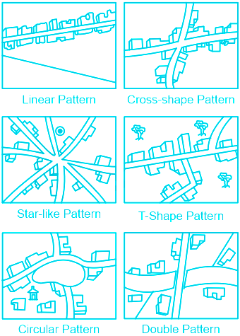
Which of the following example of the star shaped pattern?
Solution
The correct answer is Both 1 and 2
Key PointsStar shaped pattern
- This pattern of settlement develops when three or more transportation lines cross each other.
- The settlements in which houses are constructed in a star shape is known as Star like Pattern.
- Such kind of settlements is found around the points where several roads cross each other (making star shape).
- The settlements in which houses are constructed at the tri-junctions of the roads is known as T-shaped Pattern.
Examples:
- NH-47 in Tamil Nadu
- Villages in coastal Orissa
- Alabama mining state of USA
-
Question 13
5 / -1
The term Municipal Solid Waste (MSW) is generally used to describe:
Solution
Municipal Solid Waste:
- It may be defined as the organic and inorganic waste materials produced by various activities of the society, normally discarded as useless or unwanted.
- This garbage is generated mainly from residential and commercial complexes.
- It includes waste from households, hazardous solid waste from industrial and commercial establishments, waste from institutions, market waste, yard waste, and street sweeping.
- Municipal solid waste includes commercial and domestic wastes generated in municipal or notified areas in either solid or semi-solid form excluding industrial hazardous wastes but including treated bio-medical wastes.
- Municipal solid waste (MSW), commonly known as trash or garbage in the United States and rubbish in Britain, is a waste type consisting of everyday items that are discarded by the public.
Mining wastes:
- Mining waste comes from extracting and processing mineral resources.
- It includes materials such as topsoil overburden (which are removed to gain access to mineral resources), and waste rock and tailings (after the extraction of the valuable mineral).
Agricultural wastes:
- Agricultural waste is waste produced as a result of various agricultural operations.
- It includes manure and other wastes from farms, poultry houses and slaughterhouses; harvest waste; fertilizer run- off from fields; pesticides that enter into water, air or soils; and salt and silt drained from fields.
Thus, the term Municipal Solid Waste (MSW) is generally used to describe Wastes from Private homes, commercial establishments and institutions.
-
Question 14
5 / -1
ITDP refers to which one of the following?
Solution
The correct answer is Option 3.
Key Points
- The Integrated Tribal Development Programme was formally launched in 1974 with the Fifth Five Year Plan.
- The Integrated Tribal Development Projects (ITDP) under Tribal Sub-Plan (TSP) is being implemented since the Fifth Five Year Plan.
- Objectives: To reduce poverty, improve the educational status and eliminate exploitation of the tribal families.
- Ministry of Tribal Affairs releases grants to the State Governments for the implementation of the schemes/ programmes for Scheduled Tribes meant for their socio-economic development and protection against exploitation.
- This plan laid the highest priority on the development of transport and communications, agriculture and allied activities, and social and community services.
- The social benefits derived from ITDP include a tremendous increase in literacy rate, improvement in sex ratio and decline in child marriage.
- The administrative arrangements to execute this program exists in all states like the Integrated Tribal Development Authority and the system of decentralised planning, implementation and monitoring is being implemented.
-
Question 15
5 / -1
Sufficiency of which type of resources can help to create adequate social infrastructure catering to the needs of the large population in the developing countries?
Solution
Problems of Human Settlements in Developing Countries:
- The settlements in developing countries suffer from various problems, such as unsustainable concentration of population, congested housing and streets, lack of drinking water facilities.
- They also lack infrastructures such as electricity, sewage disposal, health and education facilities.
- People flock to cities to avail themselves of employment opportunities and civic amenities.
- Since most cities in developing countries are unplanned, it creates severe congestion.
- Shortage of housing, vertical expansion and growth of slums are characteristic features of modern cities of developing countries.
- In many cities, an increasing proportion of the population lives in substandard housing, e.g. slums and squatter settlements.
- In most million-plus cities in India, one in four inhabitants lives in illegal settlements, which are growing twice as fast as the rest of the cities.
- Even in the Asia Pacific countries, around 60 per cent of the urban population lives in squatter settlements.

Socio-cultural Problems:
- Cities in developing countries suffer from several social ills.
- Insufficient financial resources fail to create adequate social infrastructure catering to the basic needs of the huge population.
- The available educational and health facilities remain beyond the reach of the urban poor.
- Health indices also, present a gloomy picture in cities of developing countries.
- Lack of employment and education tends to aggravate the crime rates.
- Male selective migration to the urban areas distorts the sex ratio in these cities.
Thus, financial resources sufficiency can help to create adequate social infrastructure catering to the needs of the large population in developing countries.
-
Question 16
5 / -1
Land pollution in which land is unsuitable for farming due to high salt content is known as:
Solution
The correct answer is Salinization.
- Salinization is an increase in the total dissolved solids (TDS) as the salt of the aquifer caused by natural or anthropogenic factors.
- Salinization is a global problem.
- It tends to be concentrated in the world’s arid and semi-arid regions.
- Gypsum (calcium sulfate) or lime can be used to help leach salt from the soil.
Important Points
- Desertification is an environmental degradation that reduces the productivity of dryland ecosystems by reducing plant.
- Overgrazing is the major cause of desertification worldwide.
- Other factors that cause desertification are urbanization, climate change, overuse of groundwater, deforestation, natural disasters, and tillage practices in agriculture that make soils more vulnerable to wind.
- Carbonization is a process in which fuel is heated (900–1,200 °C) without air to leave solid porous carbon.
- By this process, cole creates coke and sub byproducts.
- Oxygenation is a process where the addition of oxygen takes place to any chemical or physical system, including the human body.
- By the process of oxygenation of the water, fish and seafood farmers can protect their stock against oxygen deficiencies during peak consumption and growth periods.
Additional Information
- The dissolved oxygen content of the water can be expressed as the absolute quantity of oxygen in one unit of water (mg/l, ppm) or as relative oxygen saturation (%).
-
Question 17
5 / -1
__________ is the latest generation of manufacturing activities with the application of research and development.
Solution
The correct answer is High technology
Key Points
Concept of High Technology Industry
- High technology, or simply high-tech, is the latest generation of manufacturing activities.
- Hence the correct answer is option 3.
- It is best understood as the application of intensive research and development (R and D) efforts leading to the manufacture of products of an advanced scientific and engineering
character. - Professional workers make up a large share of the total workforce.
- These highly skilled specialists greatly outnumber the actual production (blue-collar) workers.
- Robotics on the assembly line, computer-aided design (CAD) and manufacturing, electronic controls of smelting and refining processes, and the constant development of new chemical and pharmaceutical products are notable examples of a high-tech industry.
-
Question 18
5 / -1
Which one of the following is not a land-use category?
Solution
The correct answer is Marginal land.
- Marginal land is land with little to no agricultural or commercial value.
Key Points
- The land-use categories as maintained in the Land Revenue are as follows:
- Forests:
- It is important to note that area under actual forest cover is different from the area classified as forest.
- The latter is the area which the Government has identified and demarcated for forest growth.
- Land put to Non-agricultural Uses:
- Land under settlements (rural and urban), infrastructure (roads, canals, etc.), industries, shops, etc. are included in this category.
- An expansion in the secondary and tertiary activities would lead to an increase in this category of land use.
- Barren and Wastelands:
- The land which may be classified as a wasteland such as barren hilly terrains, desert lands, ravines, etc. normally cannot be brought under cultivation with the available technology.
- The area under Permanent pastures and Grazing Lands:
- Most of this type of land is owned by the village ‘Panchayat’ or the Government.
- Only a small proportion of this land is privately owned.
- The area under Miscellaneous Tree Crops and Goves (Not included is Net sown Area):
- The land under orchards and fruit trees are included in this category. Much of this land is privately owned.
- Culturable Waste-Land:
- Any land which is left fallow (uncultivated) for more than five years is included in this category. It can be brought under cultivation after improving through reclamation practices.
- Current Fallow:
- This is the land that is left without cultivation for one or less than one agricultural year, Fallowing is a cultural practice adopted for giving the land rest. The land recoups the lost fertility through natural processes.
- Fallow other than Current Fallow:
- This is also a cultivable land that is left uncultivated for more than five years, it would be categorized as culturable wasteland.
- Net Area Sown:
- The physical extent of land on which crops are sown and harvested is known as net sown area.
- Marginal Land
- Marginal land is land with little to no agricultural or commercial value.
-
Question 19
5 / -1
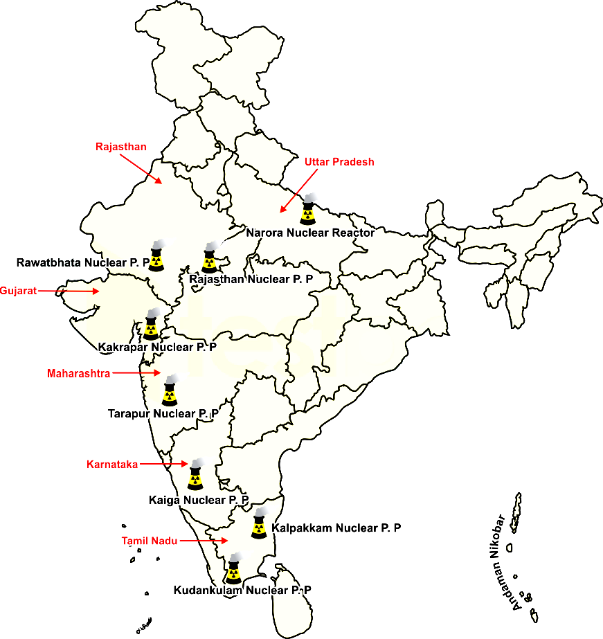
India’s first atomic power station is
Solution
The correct answer is Option 2 i.e. Tarapur atomic Power plant
- About Tarapur Atomic Power Station -
- Tarapur Atomic Power station is located in Tarapur, Maharashtra.
- It was the first commercial atomic power station of India commissioned on 28th October 1969.
- It was commissioned under 123 agreements signed between India, the United States, and International Atomic Energy Agency.
- The station is operated by the National power corporation of India.
-
Question 20
5 / -1
Rural to urban migration brings about the negative impact on urban areas
Solution
Concept:
Migration:
- When people move from one place to another, the place they move from is called the place of origin and the place they move to is called the place of destination.
- The place of origin shows a decrease in population while the population increases in the place of destination.
- Migration may be permanent, temporary or seasonal.
- It may take place from rural to rural areas, rural to urban areas, urban to urban areas and urban to rural areas.
- Migrants who move into a new place are called immigrants.
- Migrants who move out of a place are called emigrants.
- People migrate for a better economic and social life.
Urbanization:
Urban areas are characterised by high human population density and vast human-built features.
Urban areas are like cities or towns, developed by the process of urbanisation.
- Due to heavy population, urbanisation and industrialisation, several problems and threats have arisen in urban areas.
Explanation:
Negative impact on urban areas:
- Automobile exhausts increase pollution and lead level in the air.
- Intensive urban growth can lead to greater poverty with local governments unable to provide services for all their people.
- Too much dumping of waste creates multiple health hazards, that increase the rate of illness in that area.
- Here conditions are unhygienic with poor sanitation, leading to water accumulation and breeding grounds for mosquitoes, houseflies etc in nearby areas.
- Urban areas' poor drainage system leads to flooding in the lower urban are.
- Overpopulation leads to a high demand for water which causes water scarcity.
- Physical barriers to tree growth-promoting loss of urban tree cover.
- Overpopulation in urban areas leads to the loss of habitat and food sources.
- In urban areas lack of safety and high crime rate sometimes comes as a negative thing in the environment.
- Competition for a limited number of jobs (unskilled) occurs between locals and urban migrants.
- Since most cities in developing countries are unplanned, it creates severe congestion.
- In urban areas, an increasing proportion of the population lives in substandard housing, e.g. slums and squatter settlements that low the standard of living in those areas.
By increasing the risk of illness and diseases - Negative Impact
Increase in crime rate in urban areas - Negative Impact
Unemployment leads to decrease standards in urban areas - Negative Impact
Thus, All the options are correct.
-
Question 21
5 / -1
Which state has emerged as a leading sugar producer in the country and produces more than one-third of the total production of the sugar in the country?
Solution
The correct answer is Maharashtra.
Key Points
Location of the Sugar Industry
- Sugarcane is a weight-losing crop.
- The ratio of sugar to sugarcane varies between 9 to 12 per cent depending on its variety.
- Its sucrose content begins to dry during haulage after it has been harvested from the field.
- Maharashtra has emerged as a leading sugar producer in the country and produces more than one-third of the total production of sugar in the country.
- Uttar Pradesh is the second-largest producer of sugar.
- The sugar factories are concentrated in two belts the Ganga-Yamuna doab and the Tarai region.
- The major sugar-producing centres in the Ganga -Yamuna doab are Saharanpur, Muzaffarnagar, Meerut, Ghaziabad, Baghpat and Bulandshahr districts; while Kheri Lakhimpur, Basti, Gonda, Gorakhpur, Bahraich are important sugar-producing districts in the Tarai region.
-
Question 22
5 / -1
Consider the following:
1. Poor Infrastructure
2. Inadequate Health and Education
3. Unmetalled Roads
4. Absence of Irrigation
Which of the above are problems faced by Rural Settlements?
Solution
Problems of Rural Settlements
- Rural settlements in the developing countries are large in number and poorly equipped with infrastructure.
- They represent a great challenge and opportunity for planners.
- Supply of water to rural settlements in developing countries is not adequate.
- People in villages, particularly in mountainous and arid areas have to walk long distances to fetch drinking water.
- Water borne diseases such as cholera and jaundice tend to be a common problem.
- The countries of South Asia face conditions of drought and flood very often.
- Crop cultivation sequences, in the absence of irrigation, also suffer.
- The general absence of toilet and garbage disposal facilities cause health related problems.
- The design and use of building materials of houses vary from one ecological region to another.
- The houses made up of mud, wood and thatch, remain susceptible to damage during heavy rains and floods, and require proper maintenance every year.
- Most house designs are typically deficient in proper ventilation.
- Besides, the design of a house includes the animal shed along with its fodder store within it.
- This is purposely done to keep the domestic animals and their food properly protected from wild animals.
- Unmetalled roads and lack of modern communication networks creates a unique problem.
- During the rainy season, the settlements remain cut off and pose serious difficulties in providing emergency services.
- It is also difficult to provide adequate health and educational infrastructure for their large rural population.
- The problem is particularly serious where proper villagization has not taken place and houses are scattered over a large area.
-
Question 23
5 / -1
Which of the following is correct regarding Non-renewable resources?
Solution
The correct answer is They have limited stock.
Key Points
- Non-renewable resources:
- Non-renewable resources are those which have limited stock. Hence statement 1 is correct.
- Once the stocks are exhausted it may take thousands of years to be renewed or replenished.
- Since this period is much more than human life spans, such resources are considered non-renewable.
- Coal, petroleum, and natural gas are some examples of non-renewable resources.
- They are found deep inside the earth and are made by natural processes over many centuries.
Important Points
- Renewable resources:
- Renewable resources are those which get renewed or replenished quickly.
- Some of these are unlimited and are not affected by human activities, such as solar and wind energy.
- Yet careless use of certain renewable resources like water, soil, and forest can affect their stock.
-
Question 24
5 / -1
Match the following and choose the correct answer from the codes given below.
List I | List II |
A. Cheapest means of transport | i. Rail transport |
B. Land transport for bulky goods and passengers over long distances. | ii. Waterways |
C. Suitable means of transport for shorter distances | iii. Air transport |
D. Fastest means of transport for longer distance | iv. Road network |
Solution
Key Points
| Means of transport | Characteristics |
| Road transport | - Road transport is the most economical for short distances compared to railways.
- Freight transport by road is gaining importance because it offers door-to-door service.
|
| Rail transport | - Railways are a mode of land transport for bulky goods and passengers over long distances.
- The railway gauges vary in different countries and are roughly classified as broad (more than 1.5 m), standard (1.44 m), meter gauge (1 m), and smaller gauges.
- The standard gauge is used in the U.K.
|
| Water Transport | - One of the great advantages of water transportation is that it does not require route construction.
- The oceans are linked with each other and are negotiable with ships of various sizes.
- All that is needed is to provide port facilities at the two ends.
- It is much cheaper because the friction of water is far less than that of land.
- The energy cost of water transportation is lower.
- Water transport is divided into sea routes and inland waterways.
|
| Air Transport | - Air transport is the fastest means of transportation, but it is very costly.
- Being fast, it is preferred by passengers for long-distance travel.
- Valuable cargo can be moved rapidly on a worldwide scale.
- It is often the only means to reach inaccessible areas.
- Air transport has brought about a connectivity revolution in the world.
|
Hence, the correct matching is A - ii, B - i, C - iv, D - iii
-
Question 25
5 / -1
Which of the following is the leading producers of coffee in the world?
Solution
The correct answer is Brazil.
Key Points
- Coffee production in Brazil:
- The coffee plant was first brought to Brazil in the early 18th century by French settlers.
- With the rise in the popularity of coffee among Europeans, Brazil became the world's largest producer in the 1840s and has been ever since.
- According to the United States Department of Agriculture (USDA), Brazil is expected to produce 58 million 60-kilogram bags of coffee in the 2019-20 marketing year, accounting for more than a third of the world's production.
Additional Information
- Coffee production in India:
- In India, coffee is traditionally grown in the Western Ghats spread over Karnataka, Kerala, and Tamil Nadu.
- Coffee cultivation is also being expanding rapidly in the nontraditional areas of Andhra Pradesh and Odisha as well as in the North-East states.
- Coffee is predominantly an export-oriented commodity and 65% to 70% of the coffee produced in the country is exported while the rest is consumed within the country.
- The two main varieties of coffee viz., Arabica and Robusta are grown in India.
Important Points
- Vietnam is the second-largest coffee-producing nation in the world.
- Colombia is the third-largest coffee-producing nation in the world.
- Colombia is the second highest producer of Arabica beans.
-
Question 26
5 / -1
An engineered facility for the disposal of municipal solid waste is called:
Solution
Explanation:
Sanitary landfills:
- This is a method of disposal of municipal solid waste.
- In this method disposal of refuse is being carried out over the low lying area in the layers of approximately 1.5 m thick.
- Each layer after being disposed is properly compacted and left for at least 7 days before the application of another layer over it.
- This entire process is biological in approach.
- For optimum decomposition moisture content of the refuse must be greater than 60%.
- This entire process completed within 2-12 months after which the height of the landfill is reduced by 25-40%.
-
Question 27
5 / -1
The economic factor affecting economic development is ________.
Solution
The correct answer is technological advancement.
Key Points
- The economic factor affecting economic development is technological advancement.
- Other Economic affects affecting economic development are human resources, physical capital, natural resources, entrepreneurship, population growth and social overheads.
- Technological progress primarily entails research into the use of new and improved methods of production or the improvement of existing methods.
- Adoption of new production techniques facilitates economic development.
Thus, we can say that the economic factor affecting economic development is technological advancement.
-
Question 28
5 / -1
Which one of the following is not the part of the definition of a town as per the census of India?
Solution
The correct answer is the More than 75% of the population engaged in the primary sector.
Key Points
- A Census Town is an area with urban characteristics like
- A minimum population of 5,000
- At least 75% of the male main working force engaged in non-agricultural activities
- Population density of at least 400 persons per km2
- As per the 2011 Census, there are 3,784 Census Towns against 1,362 in 2001.
- A Statutory Town is one with a municipality, corporation, cantonment board, or notified town area committee.
- As per the 2011 Census, there are 4,041 such towns as against 3,799 in 2001.
- Conversion of Census towns into statutory ULBs entitles states to Central assistance as per the guidelines of the 14th Finance Commission.
- Under Atal Mission for Rejuvenation and Urban Transformation (AMRUT), 50% weightage is given to the number of statutory towns in any State/UT in the allocation of funds among States/UTs.
- The state with the highest number of census towns in West Bengal with 780 towns.
- Mizoram has no census towns.
-
Question 29
5 / -1
Which of the following is an example of non-metallic mineral?
Solution
The correct answer is Mica.
A mineral is a natural substance of organic or inorganic origin with definite chemical and physical properties. On the basis of chemical and physical properties, minerals may be grouped under two main categories of metallics and non-metallics
Key Points
Metallic minerals:
- These are the sources of metals.
- Iron ore and copper produce metal and are included in this category.
- Metallic minerals are further divided into ferrous and non-ferrous metallic minerals.
- Ferrous minerals refer to iron.
- Thus, all those minerals which have iron content are ferrous such as iron ore itself.
- For e.g iron, manganese, etc.
- Those metallic minerals which do not have iron content are referred to as non-ferrous such as copper, bauxite, aluminium, brass, lead, etc.
Non-metallic minerals
- These are either organic in origins such as fossil fuels also known as mineral fuels which are derived from the buried animal and plant life such as coal and petroleum.
- Other types of non-metallic minerals are inorganic in origin such as mica, limestone, and graphite, etc.
Additional Information
| Metallic Minerals | Distribution |
| Iron Ore | Bihar, Odisha (top 2) and also Andhra Pradesh, Madhya Pradesh, Maharashtra, Tamil Nadu, Goa |
| Bauxite | Bihar, M.P., Gujarat, Odisha, Maharashtra |
| Manganese | Karnataka, Odisha, Madhya Pradesh, Maharashtra, Goa |
| Copper | Singbhum district (Bihar), Balaghat (M.P.), and Jhunjhunu and Alwar districts (Rajasthan) |
-
Question 30
5 / -1
What is known as Hariyali guidelines ?
Solution
The correct answer is Entrusting entire responsibility for the implementation of watershed projects to Panchayats.
Key Points
- The Hariyali Guidelines (HGs) aimed at empowering panchayats, especially the gram panchayats.
- Under this new initiative, all watershed development activities would be implemented through the panchayats by providing them with necessary.
Additional Information
- The objectives of projects under Hariyali will be:
- Harvesting every drop of rainwater for purposes of irrigation, plantations including horticulture and floriculture, pasture development, fisheries, etc.
- Ensuring overall development of rural areas by creating regular sources of income for the Panchayat from rainwater harvesting and management.
- Employment generation, poverty alleviation, community empowerment.
- Mitigating the adverse effects of extreme climatic conditions.
- Restoring ecological balance by harnessing conserving and developing natural resources.
-
Question 31
5 / -1
The sustainable development aims to ensure
Solution
The sustainable development aims to ensure Sustainable consumption and production patterns.
Key Points
- The goal # 12 of the 2030 Agenda for Sustainable Development aims to ensure sustainable consumption and production patterns.
Important Points
- Some of the targets coming under SDG 12 are listed below:
- Target 12.1: Implement the 10 year sustainable consumption and production framework.
- Target 12.2: Sustainable management and use of natural resources.
- Target 12.3: Halve total per capita food waste.
- Target 12.4: Responsible management of chemicals and waste.
- Target 12.5: Substantially reduce waste generation
- Target 12.6: Encourages company to adopt sustainable practices and sustainable reporting
- In addition to that, there are several other targets like 12.7, 12.8, 12.A, 12.B and 12.C.
-
Question 32
5 / -1
______ causes extensive soil erosion.
Solution
The correct answer is excessive grazing.
Key Points
- Excessive grazing causes extensive soil erosion.
- Soil Erosion is the process that erodes, breaks or gradually diminishes things down.
- The process of erosion usually takes place on the surface of soil, rock, or dissolved material from one location on the Earth’s crust and with the help of the wind or water flow, it gets to settle down at another location.
- Flowing water, rainwater, and wind are the prime agents which cause a significant amount of soil loss each year.
- Too much soil erosion causes serious loss of topsoil and also reduces crop production potential, lower surface water quality, and damaged drainage networks.

Causes of Soil Erosion
- Running water is one of the main cause of soil erosion. Some soil erosion causes are mentioned below.
- Due to Soil Texture- If the texture is loose that is the soil contains more small grains and of open structure erodes faster.
- Slope- Soil present in a steeper slope more than the soil present at a plane level of the ground.
- Intensity or Amount of Rainfall- More intense rain, more erosion. This can be a bit slow if there are more trees present in the land as the roots of the plants hold soil in a firm manner.
- Human Activities- Agricultural practices, deforestation, roads and urbanization and global warming are a few major causes of soil erosion.
- Deforestation- Mismanaged utilization of soil resources like the removal of forest cover causes soil erosion heavily. Due to increasing land demand, the human is more into deforesting lands. Tree roots act as a binder of the top layer of the soil. And excess over grazing by animals.
Additional Information
| Crop rotation | Crop rotation is the practice of growing a series of different types of crops in the same area across a sequence of growing seasons. It reduces reliance on one set of nutrients, pest and weed pressure. |
| Contour Ploughing | Contour ploughing is the farming practice of plowing and/or planting across a slope following its elevation contour lines. |
-
Question 33
5 / -1
Who defines a primate city as being “at least twice as large as the next largest city and more than twice as significant.”?
Solution
The correct answer is Mark Jefferson
Key PointsPrimary City
- A primate city (Latin: “prime, first rank”) is the largest city in its country or region, disproportionately larger than any others in the urban hierarchy.
- First proposed by the geographer Mark Jefferson in 1939.
- He defines a primate city as being “at least twice as large as the next largest city and more than twice as significant.”
- Among the best-known examples of primate, cities are London and Paris.
- Other major primate cities include Athens, Baghdad, Bangkok, Budapest, Buenos Aires, Cairo, Dublin, Jakarta, Kuala Lumpur, Lima, Mexico City, Seoul, Tehran, and Vienna.
Additional Information
- Gottmann defined its population as 25 million.
- Doxiadis defined a small megalopolis as a similar cluster with a population of about 10 million.
-
Question 34
5 / -1
Which of the following is/are the benefits of Contour Bunding?
Solution
All the statements mentioned in given options are the benefits of Contour Bunding.
- It maintains soil fertility and reduces soil erosion.
- It is used in both cultivated and uncultivated land.
- It conserves the upper layer of soil and improves crop production.
- It promotes the absorption of water by soil and prevents soil from erosion.
-
Question 35
5 / -1
Which of the following is an abiotic resource?
Solution
Everything available in our environment which can be used to satisfy our needs can be called resources. But resources are not free gifts of nature. It is the process of transformation of things available in our environment which involves an interactive relationship between nature, technology, and institutions.
These resources can be classified in the following ways:
- On the basis of origin – biotic and abiotic.
- On the basis of exhaustibility – renewable and non-renewable.
- On the basis of ownership – individual, community, national and international.
- On the basis of the status of development – potential developed stock and reserves.
Types of resource on the basis of origin:
Biotic Resources:
- These are obtained from the biosphere and have life
- For example, human beings, flora, and fauna, fisheries, livestock, etc.
Abiotic Resources:
- All those things which are composed of non-living things are called abiotic resources.
- For example, rocks and metals. land, water, minerals, etc.
Hence, option 3 is the correct answer.
-
Question 36
5 / -1
The Channel Tunnel is the name of an undersea tunnel connecting ________.
Solution
The correct answer is option 1, i.e. France and England.
- The Channel Tunnel is an undersea tunnel linking southern England and northern France.
- It is operated by the company Eurotunnel, who also runs a railway shuttle between Folkestone and Calais, carrying passengers in cars, vans and other vehicles.
- The Channel is actually comprised of three tunnels: two rail tunnels, used for freight and passenger trains, and a service tunnel.
- The idea of a tunnel under the Channel was first proposed in 1802 but construction wasn't started until 1988. It was completed in 1993.
-
Question 37
5 / -1
Border Roads Organization is under the administrative control of the :
Solution
The Correct Answer is the Ministry of Defence.
- Border Roads Organization (BRO) was set up for coordinating the speedy development of a network of roads that develops and maintains road networks in India's border areas and friendly neighboring countries.
- It works under the administrative control of the Ministry of Defence.
Important Points
- Recently BRO has developed the Atal tunnel under Rohtang Pass.
- It is an 8.8-kilometer-long tunnel and will be the world's longest tunnel above an altitude of 3,000 meters.
- It will reduce the distance between Manali and Leh by 46 kilometers and saves transport costs.
-
Question 38
5 / -1
What are the difficulties faced by people living in slums?
Solution
Concept:
- A slum is a part of a city or a town where many poor people live.
- It is a place where people may not have basic needs.
- There are slums in most of the big cities of the world.
Explanation:
- Shelter is a major problem in big cities like Delhi.
- People from villages and towns come to big cities like Delhi in search of work.
- These people often settle in the city.
- There are a large number of people living here and the space is less.
- Many people do not have houses at all.
- They have to live in slums – and many people do not have that either.
- People sleep wherever they find a place – on the road, on the footpath, at the station.
- Characteristics of a Slum are:
- overcrowded homes
- limited or no access to basic services
- poor house condition
- lack of privacy
Thus, the difficulties faced by people living in slums is lack of space, people don't get the essential facility and lack of privacy.
-
Question 39
5 / -1
What one of the following is the main reason due to which share of forest has shown an increase in the last forty years?
Solution
The correct answer is Option 3.
Key Points
- Major policies like National Forest Policy, 1988 and other economic changes in the last four decades have greatly influenced the land use pattern in India.
- As per the India State of Forest Report, 2019, the total forest cover of the country is 7,12,249 sq km which is 21.67% of the geographical area of the country.
- The tree cover of the country is estimated as 95,027 sq km which is 2.89% of the geographical area.
- The area under forest has increased in the last forty years due to various steps of government like an increase in the recorded forest area along with the increase in the notified area allocated for forest growth. Hence, option 3 is correct.
Additional Information
- The top five states to have shown an increase in forest cover include Karnataka (1,025 sq km) > Andhra Pradesh (990 sq km) > Kerala (823 sq km) > J&K (371 sq km) > Himachal Pradesh (334 sq km).
- Forest Cover (Area-wise) : Madhya Pradesh > Arunachal Pradesh > Chhattisgarh > Odisha > Maharashtra.
- Forest Cover (Percentage): Mizoram (85.4%) > Arunachal Pradesh (79.63%) > Meghalaya (76.33%).
-
Question 40
5 / -1
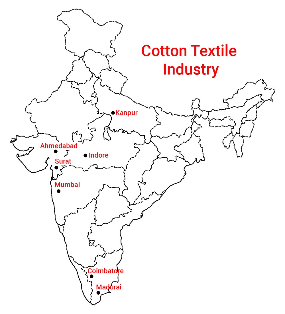
Ahmedabad, Kanpur, Lucknow and Kolkata famous for _______ industry.
Solution
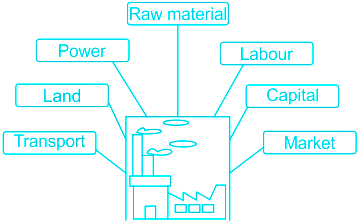
Explanation:- The location of industries is influenced by several factors like access to raw materials, power, market, capital, transport and labour, etc.
Cotton Textile Industry:
- They are among the oldest industries in India.
- Its raw material is cotton that grows in cool frost-free climates.
- Cotton can be transported easily and is non-perishable.
- Hence, its industries are located not closer to the source but to the market.
- Ahmedabad, Kanpur, Lucknow and Kolkata are huge consumers of cotton.
- Hence the industry is located in these areas.
Silk Industry:
- Silk has been a commercial product in India since ancient times.
- It was a major export item.
- Silk can also be transported easily and is non-perishable.
- In India, the silk industry is located in Karnataka, Andhra Pradesh and Tamil Nadu.
Jute:
- Jute is another fibre grown in India.
- it requires a warm and moist climate for its growth.
- It is perishable and hence industries are located close to the source of raw material.
- The plains of West Bengal provide an ideal location for the jute industry.
Sugar:
- The raw material used for sugar production is sugarcane which is perishable.
- Sugarcane grows well in a moderate climate.
- Punjab and Uttar Pradesh are the largest producers of sugarcane.
- Hence industry is also located in this area.
∴ Ahmedabad, Kanpur, Lucknow and Kolkata are famous for the cotton textile industry.
Additional Information
-
Question 41
5 / -1
Which of the following is the essential condition of urban settlement as per the census of India 1991?
Solution
The correct answer is option 2.
Key Points
- Urban areas have been recognized as “engines of inclusive economic growth”.
- Of the 121 crore Indians, 83.3 crores live in rural areas while 37.7 crores stay in urban areas, i.e approx 32 % of the population.
- The census of India, 2011 defines urban settlement as:-
- All the places which have municipality, corporation, cantonment board, or notified town area committee
- All the other places which satisfy the following criteria :
- A minimum population of 5000 persons; Hence, statement 1 is not correct.
- At least 75 % of the male main working population engaged in non-agricultural pursuits; Hence, statement 4 is not correct.
- A density of population of at least 400 persons per square kilometer. Hence, statement 2 is correct.
-
Question 42
5 / -1
What is a carbon footprint?
Solution
The correct answer is Option 3.
- Carbon footprint is the total amount of greenhouse gases released into the atmosphere as a result of the activities of a particular individual, organization, or community.
- It is usually expressed in equivalent tons of carbon dioxide (CO2).
Important Points:
- Carbon footprint is the sum of all emissions of CO2 (carbon dioxide), which were induced by all activities in a given time frame.
- Usually, a carbon footprint is calculated for the time period of a year.
-
Question 43
5 / -1
Elementary schools and university classrooms, hospitals and doctor's offices are which types of activities?
Solution
The correct answer is Quaternary.
Key Points
Quaternary activities -
- Quaternary activities centre around research, and development and may be seen as an advanced form of services involving specialised knowledge and technical skills.
- The Quaternary Sector along with the Tertiary Sector has replaced most of the primary and secondary employment as the basis for economic growth.
- Over half of all workers In developed economies are in the ‘Knowledge Sector’.
- There has been a very high growth in demand for and consumption of informationbased services from mutual fund managers to tax consultants, software developers and statisticians.
- Personnel working in office buildings, elementary schools and university classrooms, hospitals and doctors’ offices, theatres, and accounting and brokerage firms all belong to this category of services.
- Hence the correct answer is option 4.
-
Question 44
5 / -1
The Delhi-Mumbai Industrial Corridor (DMIC) project covers how many states/UT?
Solution
The correct answer is option 2 i.e Six
- The Delhi–Mumbai Industrial Corridor Project (DMIC) is a planned industrial development project between India's capital, Delhi, and its financial hub, Mumbai.
- An MOU was signed in December 2006 between Vice Minister, Ministry of Economy, Trade, and Industry (METI) of Government of Japan and Secretary, Department of Industrial Policy & Promotion (DIPP).
- DCIM passing through the SIX States -
- NCR of Delhi,
- Haryana
- Rajasthan
- Gujarat
- Maharashtra
- DCIM end terminals at Dadri in the National Capital Region of Delhi and Jawaharlal Nehru Port near Mumbai.
-
Question 45
5 / -1
Which of the following factors affect population growth?
Solution
- The population is a dynamic phenomenon.
- The numbers, distribution, and composition of the population are constantly changing.
- Growth of population refers to the change in the number of inhabitants of a country/territory during a specific period of time, say during the last 10 years.
- Such a change can be expressed in two ways: in terms of absolute numbers and in terms of percentage change per year.
- There are three main processes that contribute to population growth birth rates, death rates, and migration.

Birth rate:
- The birth rate is the number of live births per thousand persons in a year.
- It is a major component of growth because, in India, birth rates have always been higher than death rates.
Death rate:
- The death rate is the number of deaths per thousand persons in a year.
- The main cause of the rate of growth of the Indian population has been the rapid decline in death rates.
- Till 1980, high birth rates and declining death rates led to a large difference between birth rates and death rates resulting in higher rates of population growth.
- Since 1981, birth rates have also started declining gradually, resulting in a gradual decline in the rate of population growth.
Migration:
- The third component of population growth is migration.
- Migration is the movement of people across regions and territories.
- Migration can be internal (within the country) or international (between the countries).
Thus, the factors that affect population growth are Birth rate, Death rate and Migration.

Immigration: Immigration is the international movement of people to a destination country of which they are not natives or where they do not possess citizenship in order to settle as permanent residents or naturalized citizens.
Emigration: It is the act of leaving a resident country or place of residence with the intent to settle elsewhere.
-
Question 46
5 / -1
Geothermal energy is :
Solution
Geothermal energy is the heat that comes from the sub-surface of the earth. It is contained in the rocks and fluids beneath the earth’s crust and can be found as far down to the earth’s hot molten rock, magma.
- To produce power from geothermal energy, wells are dug a mile deep into underground reservoirs to access the steam and hot water there, which can then be used to drive turbines connected to electricity generators.
Advantages and Disadvantages
- There are many advantages of geothermal energy. It can be extracted without burning a fossil fuel such as coal, gas, or oil. Geothermal fields produce only about one-sixth of the carbon dioxide that a relatively clean natural-gas-fueled power plant produces.
- Unlike solar and wind energy, geothermal energy is always available, 365 days a year. It’s also relatively inexpensive; savings from direct use can be as much as 80 per cent over fossil fuels.
- But it has some environmental problems. The main concern is the release of hydrogen sulfide, a gas that smells like rotten egg at low concentrations. Another concern is the disposal of some geothermal fluids, which may contain low levels of toxic materials. Although geothermal sites are capable of providing heat for many decades, eventually specific locations may cool down.
-
Question 47
5 / -1
Which country has emerged as the leading country of medical tourism in the world?
Solution
The correct answer is India.
Key Points
Medical Services for Overseas Patients in India -
- About 55,000 patients from the U.S.A. visited India in 2005 for treatment.
- This is still a small number compared with the millions of surgeries performed each year in the U.S. healthcare system.
- India has emerged as the leading country in medical tourism in the world.
- Hence the correct answer is option 2.
- World-class hospitals located in metropolitan cities cater to patients all over the world.
- Medical tourism brings abundant benefits to developing countries like India, Thailand, Singapore and Malaysia.
- Beyond medical tourism, is the trend of outsourcing medical tests and data interpretation.
-
Question 48
5 / -1
What does the pollution in simple terms means
Solution
The Correct option is a contaminated environment.
Key Points
Explanation:
- Pollution word literally means damage caused by the presence of harmful substances.
- The presence of harmful gases in the air causes air pollution. This causes health issues for human beings and other species around.
- The presence of non - biodegradable wastes pollutes the soil.
- The presence of sewage pollutants pollutes the water.
- All these factors affect the life balance of not only mankind but other species too.
- These factors result in a contaminated environment and causes disturbance of environmental cycles.
Additional Information
Waste and its Types
- Waste includes the various types of garbages or disposable substance which are no longer in use for any particular individual.
- Waste includes
- biodegradable wastes like food remain waste paper which can be decomposed microorganisms.
- non - biodegradable wastes like polythene cannot be decomposed and causes damage to the environment.
- Waste is also classified into solid, liquid, and gaseous wastes
- Solid waste includes usual home garbage
- Liquid waste includes certain pollutants that are drained in rivers through sewage
- Gaseous waste includes pollutants released from industries, vehicles, etc.
Air Pollution:
- The presence of an excess of poisonous gas in the air causes air pollution.
- Poisonous gases are released by vehicles and industries which pollute the air.
Water Pollution
- The presence of pollutants in water is termed water pollution which creates a major impact on the aquatic ecosystem.
- The water pollution is caused by liquid sewage waste released in rivers.
Soil Pollution
- The presence of unwanted chemicals in soil pollutes the soil.
- Such chemicals are induced in soil by chemicals obtained from domestic or industrial garbage.
- Soil pollution causes loss of fertility of the soil and impacts agricultural productivity.
-
Question 49
5 / -1
What is the predominant type of Indian agriculture?
Solution
The correct answer is Subsistence agriculture.
- Indian Agriculture
- Agriculture plays a vital role in the Indian economy.
- Over 70 percent of rural households depend on agriculture.
- Agriculture is an important sector of the Indian economy as it contributes about 17% to the total GDP and provides employment to around 58% of the population.
- Indian agriculture has registered impressive growth over the last few decades.
- The foodgrains production has increased from 51 million tonnes (MT) in 1950-51 to 250MT during 2011-12 highest ever since independence
- The share of agriculture in GDP increased to 19.9 percent in 2020-21 from 17.8 percent in 2019-20.
- The last time the contribution of the agriculture sector in GDP was at 20 percent was in 2003-04.
- The predominant type of Indian agriculture is subsistence agriculture. Hence, Option 4 is correct.
- In this, farmers grow food to feed themselves and their dependents.
Additional Information
- Features of intensive subsistence agriculture:
- Small Holdings:
- It is practiced in a smaller piece of land to meet the personal need first and sell the rest of it is in surplus.
- Very Intensive Farming:
- Due to the very limited space of usable land for agriculture, farmers try to make as much as possible with their crops.
- The farming is so intensive that they sometimes practice double- or treble-cropping.
- Requires Much Hand Labour:
- The intensive subsistence farmers don’t use much technology in their farming nor much machinery and thus much hand labour is required.
- These farmers usually use traditional techniques and simple tools to produce the best products possible.
- Use Of Animal And Plant Manures:
- Farmers often use every available type of manure such as farm wastes, rotten vegetables, animal dung, human excreta, etc.
-
Question 50
5 / -1
Hunting, gathering, fishing and forestry are examples of which of the following activities given below?
Solution
The correct answer is Primary.
Key Points
Human activities
- Human activities which generate income are known as economic activities.
- Economic activities are broadly grouped into primary, secondary, tertiary and quaternary activities.
- Primary activities are directly dependent on the environment as these refer to the utilisation of the earth’s resources such as land, water, vegetation, building materials and minerals.
- It, thus includes hunting and gathering, pastoral activities, fishing, forestry, agriculture, and mining and quarrying.
- Hence the correct answer is option 1.


 ×
×

 Sign in
 Profile
 Signout