-
Question 1
5 / -1
Which type of farming is practiced in areas of high population pressure on land?
Solution
The Correct Answer is Intensive subsistence farming.
 Key Points
- In intensive subsistence farming, the farmer cultivates a small plot of land using simple tools and more labour.
- Intensive subsistence agriculture is prevalent in the thickly populated areas of the monsoon regions of the south, southeast, and east Asia.
 Important Points
Commercial Farming
- In commercial farming, crops are grown and animals are reared for sale in the market.
- The area cultivated and the amount of capital used is large. Most of the work is done by machines.
- Commercial farming includes commercial grain farming, mixed farming, and plantation agriculture.
Primitive subsistence farming
- Primitive subsistence agriculture includes shifting cultivation and nomadic herding.
Extensive subsistence agriculture
- Extensive subsistence agriculture is farming in thinly populated areas.
- The vast expanse of land is cultivated to yield minimal output of crops and animals for the primary consumption of the grower's family.
-
Question 2
5 / -1
Which of the following is not a commercial crop in India?
Solution
- Commercial agriculture, or otherwise known as agribusiness, is a cropping method in which crops or livestock are raised in order to sell the products on the market in order to make money.

Commercial crop:
- Commercial farming is a form of market-oriented and profit-motivated farming.
- In this farming, consumption of the cultivated products by the farmers, if at all done, is an insignificant proportion of the total production.
- It occupies a large area of cultivation and requires significant capital input along with heavy use of machinery.
- It includes commercial grain farming, mixed farming, and plantation agriculture.
- Commercial farming includes commercial grain farming, mixed farming, and plantation agriculture.

Commercial crops:
- Coffee
- Cotton
- Jute and Mesta
- Oilseeds
- Opium (Afeem)
- Rubber
- Sannhemp
- Sugarcane
- Tea
- Tobacco
Thus, maize is not a commercial crop in India.

Food crops:
- These crops are grown for food such as cereals: wheat, rice maize, pulses, etc.
- These grow in the plains generally.
- These are annuals and complete their cycle in one season as in the case of wheat, rice, maize, gram.
-
Question 3
5 / -1
The ratio of gross cropped area to the net sown area is called:
Solution
The correct answer is cropping intensity.
- In News:
- In a recent study, it has been found that groundwater depletion in India could reduce winter cropped acreage significantly in the years ahead.
- The researchers studied India’s three main irrigation types on winter cropped areas: dug wells, tube wells and canals.
Key Points
- Cropping Intensity:
- It refers to the raising of a number of crops from the same field during one agricultural year; it can be expressed through a formula.
- Cropping Intensity = Gross Cropped Area/Net Sown Area x 100.
- The present cropping intensity of 136% has registered an increase of only 25% since independence. Further, rainfed drylands constitute 65% of the total net sown area.
- Present Scenario:
- Even if all regions that are currently using depleted groundwater for irrigation will switch to using canal irrigation, cropping intensity may decline by 7% nationally and by 24% in the most severely affected locations.
- Groundwater depletion in India could result in a reduction in food crops by up to 20% across the country and up to 68% in regions projected to have low future groundwater availability in 2025.
- India produces 10% of the world’s crops and is now the world’s largest consumer of groundwater, and aquifers are rapidly becoming depleted across much of India.
- The Indian government has suggested that switching from groundwater-depletion wells to irrigation canals is one way to overcome projected shortfalls.
-
Question 4
5 / -1
Which one of the following countries has the highest sex ratio in the world?
Solution
The correct answer is Latvia.
Key Points
- In India, the sex ratio is the number of females per thousand males.
- On average, the world population reflects a sex ratio of 102 males per 100 females.
- The highest sex ratio in the world has been recorded in Latvia where there are 85 males per 100 females. In contrast, in Qatar, there are 311 males per 100 females.
- The world pattern of sex ratio does not exhibit variations in the developed regions of the world.
- The sex ratio is favourable for females in 139 countries of the world and unfavourable for them in the remaining 72 countries listed by the United Nations.
-
Question 5
5 / -1
Which one of the following is not a fossil fuels?
Solution
The correct answer is Biogas.
Key Points
- Biogas produced by microbes is used as a source of energy in rural areas.
- Biogas can be compressed after the removal of carbon dioxide.
- It can be used to power motor vehicles.
- Animal and plant wastes can also be used to produce biogas.
- Methane and Carbon-dioxide are the main constituents of biogas.
- The process of biogas production is also called anaerobic digestion.
- Biogas is usually made up of:
- Around 25-45% carbon dioxide (CO₂).
- Around 50-70% methane (CH4).
 Additional Information
- Liquefied petroleum gas:
- Liquefied petroleum gas consists of propane and butane.
- Liquefied petroleum gas is used as fuel for home and industry.
- Compressed natural gas:
- It can be used in place of petrol, diesel, and LPG.
- CNG is made by compressing natural gas.
- It is mainly composed of methane.
- It occupies at standard atmospheric pressure.
-
Question 6
5 / -1
Which famous economist developed the human development index?
Solution
The correct answer is Mahbub ul Haq.
- Mahbub ul Haq was a Pakistani economist.
- He served as the former Finance Minister of Pakistan
- The human development index was developed by Mahbub ul Haq in 1990.
- He is widely regarded as "the most articulate and persuasive spokesman for the developing world".
- The Human Development Index (HDI) is a statistical tool used to measure a country's overall achievement in its social and economic dimensions.
- United Nations Development Program (UNDP) is the agency responsible for creating the Human Development Index.
- Norway tops in the Human Development Index 2019.
- India ranks 129 out of 189 countries on the 2019 Human Development Index (HDI).
| Richard H. Thaler | - American economist.
- Served as the president of the American Economic Association.
- He was awarded the Nobel Prize in Economic Sciences for his contributions to behavioural economics in 2017.
|
| Adam Smith | - Scottish economist.
- Well known as ''The Father of Economics''.
- Notable works:
- The Theory of Moral Sentiments.
- An Inquiry into the Nature and Causes of the Wealth of Nations.
|
| Dadabhai Naoroji | - Father of Indian economics.
- The propounder of the Drain of Wealth Theory.
- The first person attempted to calculate national income in India.
|
-
Question 7
5 / -1
O.F.C (Optical Fibre Cable) is used in internet communication because of:
Solution
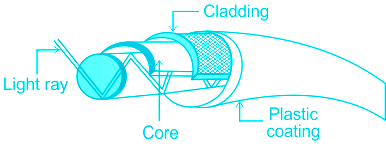
Concept:
- Optical fibre is a hair-like wire used for data transmission.
- It is consist of a core at the centre and cladding around it with different refractive index.
- The diameter of core and cladding is approximately 10μm and 125μm respectively.
- The phenomenon of total internal reflection is used for data transmission.
Explanation:
- Optical fibre cable has many advantages over copper.
- Greater bandwidth: The bulk of data can be transferred in less amount of time.
- It can transfer data from 200 Mb/s to 100 Gb/s.
- High data-carrying capacity.
- Fast speed: Speed of transmission is significantly faster than copper up to 100 Gbps.
- Data is transferred with the speed of light.
- Longer distance: Maximum distance for copper cable is 100 meters but optical fibre cable can achieve a distance 10 times Km.
- Better reliability: Data is not affected due to weather change, temperature change.
- It can also transfer data underwater.
- Compact structure: Its structure is very thin and lightweight.
- It can handle more pressure, breakage, and damages are avoided due to structure.
- Flexible: OFC is very flexible it can easily bend and corrosion is resisted.
- Although its cost is higher than copper.
- Option 3 is correct.
-
Question 8
5 / -1
Which Port is situated at the head of Vembanad Kayal, popularly known as the ‘Queen of the Arabian Sea’?
Solution
The correct answer is Kochchi Port.
Key Points
Kachchi Port
- Kachchi Port situated at the head of Vembanad Kayal, popularly known as the ‘Queen of the Arabian Sea’, is also a natural harbour.
- Hence the correct answer is option 1.
- This port has an advantageous location being close to the Suez-Colombo route.
- It caters to the needs of Kerala, southern Karnataka and south western Tamil Nadu.
Additional Information Chennai Port
- Chennai Port is one of the oldest ports on the eastern coast.
- It is an artificial harbour built-in 1859.
- It is not suitable for large ships because of the shallow waters near the coast.
- Tamil Nadu and Puducherry are its hinterlands.
Kolkata Port
- Kolkata Port is located on the Hugli river 128 km inland from the Bay of Bengal.
- Like the Mumbai port, this port was also developed by the British.
- Kolkata had the initial advantage of being the capital of British India.
Jawaharlal Nehru Port
- Jawaharlal Nehru Port at Nhava Sheva was developed as a satellite port to relieve the pressure at the Mumbai port.
- It is the largest container port in India.
-
Question 9
5 / -1
In which of the following urban settlements is the first well-documented city to reach one million populations?
Solution
The first urban settlement to reach a population of one million was the city of London by around. A.D. 1810
-
Question 10
5 / -1
Given below are two statements: One is labelled as Assertion (A) and the other is labelled as Reason (R) :
Assertion (A): In areas of intensive subsistence agriculture animal husbandry is a meagre sideline of crop farming
Reasons (R): Throughout the region. the farmers are handicapped in raising cattle due to a lack of scientific methods of breeding the animals.
In light of the above Statements. choose the most appropriate answer from the options given below:
Solution
Characteristics of Intensive Subsistence Farming:
- Intensive farming is an agricultural intensification and mechanization system that aims to maximize yields from available land through various means, such as heavy use of pesticides and chemical fertilizers.
- Three major characteristics of intensive farming are as follows,
- Low fallow ratio
- Labour and capital intensive
- Higher crop yields per unit land area.
- That means high output per unit of land and relatively low output per worker
- Executive use of mechanization found.
- It is a labour-intensive farming method.
- This farming produces cheaper food per hectare to feed the rising population.
- Created multiple cropping systems.
- High productivity using modern inputs.
- It also involves intensive livestock farming.
- It is a common practice in the fertile areas of south-east Asia, China, India (Punjab, parts of Rajasthan, Madhya Pradesh, etc.), etc.
Intensive livestock farming:
- In areas of intensive subsistence agriculture. animal husbandry is a meagre sideline of crop farming
- This is clearly more sophisticated than primitive agriculture. Sometimes it is also known as the ‘monsoon type of agriculture’.
- Subsistence farming is being superseded by intensive animal farming in the more developed parts of the world, where for example beef cattle are kept in high-density feedlots, and thousands of chickens may be raised in broiler houses or batteries.
- Throughout the region. the farmers are handicapped in raising cattle due to a lack of scientific methods of breeding the animals
Therefore, Both (A) and (R) are correct but (R) is NOT the correct explanation of (A).
-
Question 11
5 / -1
What are the causes of salinization, alkalinization and waterlogging?
Solution
The correct answer is All of the above
Key PointsThe causes of salinization, alkalinization and waterlogging
- Driving forces for natural soil salinity and alkalinity are climate, rock weathering, ion exchange, and mineral equilibria reactions that ultimately control the chemical composition of soil and water.
- The major weathering reactions that produce soluble ions are tabled.
- Where evapotranspiration is greater than precipitation, downward water movement is insufficient to leach solutes out of the soil profile and salts can precipitate.
- Microbes are involved in organic matter mineralization and thus the carbon, nitrogen, and sulfur biogeochemical cycles are also implicated.
- Seasonal contrast and evaporative concentration during dry periods accelerate short-term oxidation-reduction reactions and local and regional accumulation of carbonate and sulfur minerals.
- The presence of salts and alkaline conditions, together with the occurrence of drought and seasonal waterlogging, creates some of the most extreme soil environments where only specially adapted organisms are able to survive.
- Sodic soils are alkaline, rich in sodium carbonates, with an exchange complex dominated by sodium ions.
- Such sodic soils, when low in other salts, exhibit dispersive behavior, and they are difficult to manage for cropping.
- Maintaining the productivity of sodic soils requires control of the flocculation-dispersion behavior of the soil.
- Poor land management can also lead to anthropogenically induced secondary salinity.
- New developments in physical chemistry are providing insights into ion exchange and how it controls flocculation-dispersion in soil.
- New water and solute transport models are enabling better options of remediation of saline and/or sodic soils.
-
Question 12
5 / -1
Autobahns a term for roadways is used in which country?
Solution
The correct answer is Germany.
Key Points
Roads
- Road transport is the most economical for short distances compared to railways.
- Freight transport by road is gaining importance because it offers door-to-door service
- The quality of the roads varies greatly between developed and developing countries because road construction and maintenance require heavy expenditure.
- In developed countries good quality roads are universal and provide long-distance links in the form of motorways, autobahns (Germany), and interstate highways for speedy movement.
- Hence the correct answer is option 1.
- Lorries, of increasing size and power to carry heavy loads, are common.
-
Question 13
5 / -1
The most effective crop for reducing soil erosion is one of the following:
Solution
The correct answer is Green Gram.
Key PointsSoil Erosion
- Soil erosion is a gradual process that occurs when the impact of water or wind detaches and removes soil particles, causing the soil to deteriorate.
- Soil deterioration and low water quality due to erosion and surface runoff have become severe problems worldwide.
- The problem may become so severe that the land can no longer be cultivated and must be abandoned.
- Many agricultural civilizations have declined due to land and natural resource mismanagement, and the history of such civilizations is a good reminder to protect our natural resources.
- Strip cropping is a method of farming in which more than one variety of crops is grown in different strips.
- One of the important crops that is usually grown along with other crops is the gram. This is because it has good soil holding capacity and prevents soil erosion.
- The impact of soil erosion on water quality becomes significant, particularly as soil surface runoff.
- Therefore, the most effective way to minimize sediment production is the stabilization of the sediment source by controlling erosion.
- Soil erosion is the detachment and movement of soil particles from the point of origination through the action of water or wind.
- Thus, minimizing the impact of water or wind forces is the main objective of erosion control. Water erosion is the most pertinent erosion problem in Iowa.
Additional InformationGram
- Gram is an important rabi crop mainly sown in September-November and harvested in February.
- Crop duration is 90-120 days, depending on the variety. Desi varieties are short duration while Kabuli varieties take relatively longer period to mature.
-
Question 14
5 / -1
Which method of soil conservation is most suitable in the coastal and dry regions?
Solution
The correct answer is Shelterbelts.
Key Points
- A shelterbelt is a barrier of trees and shrubs that provides protection from wind and storm and lessens erosion.
- Shelterbelts are a specific type of agroforestry system that help reduce natural hazards.
- It is the most suitable method of soil conservation in coastal and dry areas.
- Soil conservation is the protection of soil from erosion and other types of deterioration, so as to maintain soil fertility and productivity.
Thus, we can say that Shelterbelts is the most suitable method of soil conservation in the coastal and dry regions.
-
Question 15
5 / -1
Identify the type of farming:
A) Crops are grown and animals are reared for sale in the market.
B) The area cultivated and the amount of capital used is large.
C) Most of the work is done by machines.
Solution
Farming is the act or process of working the ground, planting seeds, and growing edible plants.
- It can also describe raising animals for milk or meat as farming. Farming is a great way to describe the lifestyle and work of people whose jobs are in the agriculture industry.
- There are various types of farming.
Important Points
- In commercial farming, crops are grown and animals are reared for sale in the market. which resulted in a profit for the farmers.
- The area cultivated and the amount of capital used are large. This is done with the increased production levels.
- Most of the work is done by machines.
- Commercial farming includes commercial grain farming, mixed farming, and plantation agriculture.
Hence, Commercial farming is mainly done by machines and in large areas. Which eventually increases the production of agricultural products.
-
Question 16
5 / -1
Which of the following are not the part of continuous landmass?
Solution
The correct answer is Asia.
Key PointsLandmass
- There are four major continuous landmasses on Earth: Afro-Eurasia, the Americas, Antarctica, and Australia.
- Covering an expanse of over 6.6 million square miles, Russia is the world's largest country by landmass, beating out runner-up Canada by around 2.8 million square miles.
- Most geologists recognize six continents — Africa, Antarctica, Eurasia, Australia, North America, and South America
-
Question 17
5 / -1
What is also called drainage basin/catchment area?
Solution
The correct answer is Watershed.
Key PointsWatershed
- A watershed (also called drainage basin/catchment area) is an area of land that drains or “sheds” water into a specific waterbody.
- It is an independent drainage unit for surface water runoff.
- One watershed is separated from another by a natural boundary known as the water divide or the ridgeline.
Types of Watershed: They are classified depending on the size, drainage, shape, and land use pattern.
- Macro watershed (> 50,000 Ha)
- Sub-watershed (10,000 to 50,000 Ha)
- Milli-watershed (1000 to 10,000 Ha)
- Micro watershed (100 to 1000 Ha)
- Mini watershed (1-100 Ha)
-
Question 18
5 / -1
Which is the major rail route of Russia that runs from St. Petersburg in the west to Vladivostok on the Pacific Coast?
Solution
The correct answer is Trans–Siberian Railway.
Key Points
Trans–Siberian Railway -
- This is a trans–Siberian Railways major rail route of Russia runs from St. Petersburg in the west to Vladivostok on the Pacific Coast in the east passing through Moscow, Ufa, Novosibirsk, Irkutsk, Chita and Khabarovsk.
- Hence the correct answer is option 1.
- It is the most important route in Asia and the longest (9,332 km)double-tracked and electrified trans–continental railway in the world.
- It has helped in opening up its Asian region to West European markets.
- It runs across the Ural Mountains Ob and Yenisei rivers Chita is an important agro centre and Irkutsk, a fur centre.
-
Question 19
5 / -1
____________ is the natural flooding and over-irrigation that brings water at underground levels to the surface.
Solution
The correct answer is Water logging.
Key PointsWater logging
- Waterlogging is the natural flooding and over-irrigation that brings water at underground levels to the surface.
- As a consequence, displacement of the air occurs in the soil with corresponding changes in soil processes and an accumulation of toxic substances that impede plant growth.
- Waterlogged soils release increased amounts of nitrous oxide (N2O), a particularly damaging greenhouse gas.
- Waterlogging occurs when the soil profile or the root zone of a plant becomes saturated. In rain-fed situations, this happens when more rain falls than the soil can absorb or the atmosphere can evaporate.
- Western Australia’s ‘Mediterranean’ climate of cool and wet winters and hot dry summers produces more rain than the atmosphere can evaporate every winter.
- The amount of ‘excess’ rain is particularly large in the higher rainfall areas of the south-west.
-
Question 20
5 / -1
Which one of the following is NOT the part of the definition of a town as per the census of India?
Solution
The correct answer is Option 3.
Key Points
- As per the census 2011, Places that satisfy the following criteria are called census towns:
- A minimum population of 5,000;
- At least 75 per cent of the male main working population engaged in non-agricultural pursuits; and Hence, option 3 is not correct.
- A density of population of at least 400 persons per sq. km.
- Presence of municipality, corporation, etc
Additional Information
- Towns are classified into different classes based on the size of population:
- Class I: 100,000 and above;
- Class II: 50,000 to 99,999;
- Class III: 20,000 to 49,999;
- Class IV: 10,000 to 19,999;
- Class V: 5,000 to 9,999 and
- Towns with population of 1,00,000 and above are called cities.
-
Question 21
5 / -1
Sex ratio is defined as:
Solution
Concept:-
As per Census 2011, Haryana has the lowest sex ratio, i.e., the number of females per 1000 males.
- The sex ratio is a valuable source for identifying the female population in India and what is the ratio between women and men in India.
- It was revealed in the 2011 Population Census that the Indian population ratio 2011 is 940 females per 1000 males.
- Haryana has India's lowest sex ratio and the figure shows a number of 877 females to 1000 males.
- Puducherry and Kerala where there are more women than men.
- Kerala has India's highest sex ratio and the figure shows a number of 1084 females to 1000 males.
-
Question 22
5 / -1
Petrochemicals are used in the manufacture of________.
Solution
The correct answer is Detergent.
Key Points
- Petrochemicals are used in the manufacture of detergent.
- Detergent is a substance that's used for cleaning.
- Detergent is similar to soap, but it's stronger and dissolves more completely in water.
- Detergents are special, powerful cleansers that can break up dirt, oils, and grease in clothing or on dishes.
- The most important raw material for synthetic detergent production alkylbenzene.
- The alkyl molecular group has in the past usually been C12H24 (tetrapropylene) obtained from the petrochemical gas propylene.
- This molecular group is attached to benzene by a reaction called alkylation, with various catalysts, to form the alkylbenzene.
-
Question 23
5 / -1
What do you understand by common property resource?
Solution
The correct answer is Option A.
Key PointsCommon Property Resource
- CPRs can be defined as a community’s natural resource, where every member has the right of access and usage with specified obligations, without anybody having property rights over them.
- CPRs provide fodder for the livestock and fuel for the households along with other minor forest products like fruits, nuts, fibre, medicinal plants, etc.
- In rural areas, such land is of particular relevance for the livelihood of the landless and marginal farmers and other weaker sections since many of them depend on income from their livestock due to the fact that they have limited access to land.
- CPRs also are important for women as most of the fodder and fuel collection is done by them in rural areas.
-
Question 24
5 / -1
Which group of profession from the following came under tertiary sector of economy?
Solution
The correct answer is Teacher, Doctor, Barber.
Key Points
- Tertiary Sector
- The tertiary Sector is a collection of industries that produce mostly intangible value, meaning value that has no physical form.
- It is a hallmark of advanced economies to have a large tertiary sector that generates a high percentage of GDP and employment.
- The tertiary sector is also called as service sector.
- This sector also includes essential services that may not directly help in the production of goods.
- Examples: Education, Utilities, Transportation, Hospitality, etc.
- For example, we require teachers, doctors, tailors, some of which provide us with personal services.
- Primary Sector
- The sector that includes the different raw materials is also known as the primary sector.
- This sector includes all of the sectors of human activity that transform natural resources into commodities.
- These raw materials are products generated from agriculture, crop production, animal husbandry, fishing, forestry, and mining.
- The activities carried out in the primary sector are important, necessary, and indispensable for the populations' survival.
- Secondary Sector
- The secondary sector includes economic activities that create finished products for consumption( consumer goods).
- It takes the production of the primary activities and manufactures new end goods.
- Examples: Manufacturing, Construction, etc.
-
Question 25
5 / -1
The type of farming which uses less labor for cultivating large area of land by farmers is called as:
Solution
Under extensive agriculture, less labor is used for cultivating larger area of land by farmers. It is opposite to intensive subsistence farming. Famers opt for such farming to produce more by using less labor, less fertilizers and capital on more land. Such type of farming uses machinery and scientific methods of farming large quantity of crops.
-
Question 26
5 / -1
Which of the following sentence is correctly define slum?
Solution
The correct answer is a Highly populated and poor areas in the city.
Key PointsSlum
- The word “slum” is often used to describe informal settlements within cities that have inadequate housing and squalid, miserable living conditions. Hence, statement 2 is correct.
- They are often overcrowded, with many people crammed into very small living spaces.
- These settlements lack basic municipal services such as water, sanitation, waste collection, storm drainage, street lighting, paved sidewalks and roads for emergency access.
- Most also do not have easy access to schools, hospitals or public places for the community to gather.
- UN-HABITAT defines a slum household as a group of individuals living under the same roof in an urban area who lack one or more of the following:
- Durable housing of a permanent nature that protects against extreme climate conditions.
- Sufficient living space, which means not more than three people sharing the same room.
- Easy access to safe water in sufficient amounts at an affordable price.
- Access to adequate sanitation in the form of a private or public toilet shared by a reasonable number of people.
- Security of tenure that prevents forced evictions.
-
Question 27
5 / -1
Which among these is the highest motorable pass in the country?
Solution
The correct answer is Umling La
Key Points
- Umling La, situated at an elevation of more than 19300 feets (5,799 m) above sea level is the highest motorable pass in the country.
- It connects Chisumle and Demchok village.
- The road was recently completed by the Border Roads Organization of India at Umling La, making it the world's highest motorable road and pass.
- The pass is located at kilometer 24, part of the 52 kilometres (32 mi) Chisumle-Demchok road.
Additional Information
Chang La Pass | Ladakh, 5,360 m above sea level |
Bomdi La Pass | Arunachal Pradesh, 4,600 m above sea level |
| Diphu Pass | Arunachal Pradesh, 4,587 m above sea level |
-
Question 28
5 / -1
Milpa and Ladang are different names for
Solution
The correct answer is shifting cultivation.
Key Points
- Shifting cultivation is a form of agricultural practice or a cultivation system.
- In which an area of ground is cleared of vegetation and cultivated for a few years and then abandoned for a new area until its fertility has been naturally restored.
- It is practised by tribal and is also known as Burn and Slash cultivation.
- It is known as Jhoom in Assam, Onam in Kerala, Podu in Andhra Pradesh, and Odisha. The same is known as Bewar in Madhya Pradesh.
Additional Information
- Key Features of Shifting Cultivation:
- Use of fire for clearing the land.
- Rotation of fields.
- Use of human labour as the main input.
- Keeping the land fallow for regeneration for a number of years.
- Non-employment of draught animals.
- Non-use of the plough, but instead very crude and simple implements such as dibble sticks and scrapers, are used.
- All the crops being grown are mixed together.
- In most parts of Northeast India, it is found that hunting and gathering is an important subsidiary occupation of the shifting cultivators.

List of local names of shifting cultivation around the world.| Name of Shifting Cultivation | Region |
| Ray | Vietnam |
| Tavi | Madagascar |
| Masole | Congo (Zaire River Valley) |
| Fang | Equatorial African Countries |
| Logan | Western Africa |
| Comile | Mexico |
| Milpa | Yucatan and Guatemala |
| Echalin | Guadeloupe |
| Konuko | Venezuela |
| Roka | Brazil |
-
Question 29
5 / -1
What do you understand by the term Tankas?
Solution
The correct answer is option 2.
Key PointsTankas
- It is a cylindrical paved underground pit into which rainwater from rooftops, courtyards or artificially prepared catchments flows.
- It is indigenous to the Thar Desert region of Rajasthan.
- Rainwater harvesting/storage in an underground cistern locally known as Tanka is an age-old common practice in western Rajasthan.
- Various types of tanka from rectangular to circular in shape and capacity ranging from as small as 1000 liters to 500,000 liters are prevalent in this region.
- The availability of water in these tankas was usually round the year for drinking purposes for the whole family.
- The traditional construction of tanka varies from simple mud plaster to lime mortar, however, wide variations have been observed.
Additional Information
Traditional Rainwater Harvesting (TRH) Structures:
- Hundreds of years ago, the rulers of princely states in Rajasthan had created structures for rainwater harvesting, now called traditional rainwater harvesting (TRH) structures.
- These structures catered to the local needs utilized local resources and were based on the wisdom and knowledge handed down from generation to generation.
- They were replenished each year with monsoon rain and served the people all around the year.
- Many community TRH structures also had temples or religious associations with them and became centers of pilgrimage. Many were built with royal patronage or rich businessmen.
- The main TRH structures in Rajasthan, namely, kundi, kui/beri, baori/ber, jhalara, nadi, toba, tanka, khadin, johad and anicut are described below in brief.
- A kundi is essentially a circular underground well with a saucer-shaped catchment area that gently slopes towards the centre where the well is situated. A wire mesh across water inlets prevents debris from falling into the well pit. The sides of the well-pit are covered with lime and ash. Most wells have a dome-shaped cover for protection.
- A kui/beri is a 10-12 meter deep pit dug near tanks to collect the seepage. It is used to harvest rainwater in areas with meager rainfall. The month of the pit Is made narrow to prevent the
-
Question 30
5 / -1
Which of the following is the name the three stages of demographic transition theory?
Solution
The Demographic Transition Model was developed by the American demographer Warren Thompson in 1929.
The five stages of the demographic transition model
- Stage One: The Pre-Industrial Stage (highly fluctuating – high stationery)
- Stage Two: The Industrial Revolution (early expanding) –very rapid increase.
- Stage Three: Post-Industrial Revolution (late expanding) –increase slows down.
- Stage Four: Stabilization (low stationery) – very slow increase
- Stage Five: Declining population
Hence the correct answer is Rural agrarian, demographic transition, urban industrial.
Stage One:
- Both birth rate and death rate are high
- The population fluctuates due to the incidence of famine, disease, and war.
- High infant mortality and very low life expectancy.
- Rural societies are dependent on subsistence agriculture.
- The total population is low and balanced due to high birth rates and high death rates.
- Isolated tribes in Amazon
Stage Two:
- The death rate falls sharply due to improvements in health care and sanitation.
- Birth rates remain high. The total population grows very quickly.
- Improvement in farming technology and increase in the food supply
- Better nutrition, water supply, sewage, and personal hygiene and improvement in the public health system.
- Increase in female literacy combined with public health education programs
- Afghanistan, Pakistan, Bolivia, sub-Saharan
Stage Three:
- The birth rate falls due to the availability of contraception.
- Reduction of child labor- fewer children are needed to work on the farm due to the mechanization of farming
- The death rate stays at a low level due to improved health conditions
- An increase in the status and education of women
- The total population still rises rapidly due to population momentum.
- The gap between birth and death rates narrows down
- Costa Rica, Panama, Jamaica, Mexico, Colombia, Ecuador, Philippines, Indonesia, Malaysia, Sri Lanka, Turkey, Azerbaijan, Turkmenistan, Uzbekistan, Egypt, Tunisia, Algeria, Morocco, Lebanon, South Africa, India.
-
Question 31
5 / -1
Which theory says that the true and only geographical problem is that to utilisation of possibilities?
Solution
The correct answer is Possibilism
Key PointsPossibilism
- Possibilism is reaction to determinism and environmental determinism.
- It is based upon the assumption that environment sets certain constraints or limitations, but culture is otherwise determined by social conditions.
- This theory says that the true and only geographical problem is that to utilisation of possibilities.
- Essence of Possibilism is that:
- Nature provides possibilities and man utilises them according to his culture, traditions, and levels of socioeconomic development.
- People are not just the products of their environment or just pawn of natural environment.
- Nature is never more than an adviser.
- There are not necessities but everywhere possibilities.
- The range of possibilities in every region is limited more by the price man is willing to pay of what he wants than by the dictates of environment. For instance, man through his technical skill can grow banana, rice and rubber plants in tundra, Greenland, and Antarctica, but he has to take into consideration the input cost.
- The prohibitive cost of production of these crops in the extremely cold conditions of these areas will compel man not to grow them in the tundra climate.
-
Question 32
5 / -1
Consider the following:
1. Delhi
2. Kolkata
3. Hyderabad
4. Bengaluru
Which of the above is/are mega cities?
Solution
Out of 468 cities, 53 cities/urban agglomerations are metropolitan cities. Six of them are mega cities with a population over five million each.
- Mumbai, Delhi, Kolkata, Chennai, Bengaluru and Hyderabad are other mega cities in the country.
- More than one-fifth (21.0%) of urban population lives in these mega cities.
-
Question 33
5 / -1
Which of the following does not belong in the category of municipal solid waste?
Solution
The correct answer is Radioactive substance.
Key PointsMunicipal Solid Waste
- Municipal solid waste (MSW) is defined as waste collected by the municipality or disposed of at the municipal waste disposal site and includes residential, industrial, institutional, commercial, municipal, and construction and demolition waste
- The term “garbage” can also refer to food waste, as in a garbage disposal; the two are sometimes collected separately.
- Municipal solid waste (MSW) composition varies greatly from municipality to municipality and changes significantly over time.
- In municipalities with a well-developed waste recycling system, the waste stream consists primarily of difficult-to-recycle wastes such as plastic film and non-recyclable product packaging materials.
- At the turn of the century, most domestic waste in the United Kingdom (53 percent) was coal ash from open fires.
- Food wastes, market wastes, garden waste, containers, product packaging material, and other miscellaneous solid wastes from residential, commercial, institutional, and industrial sources predominate in developed areas with little recycling activity.
-
Question 34
5 / -1
In which of the following regions has the oldest well-documented urban settlement found?
Solution
Urban Settlements in India
- Towns flourished since prehistoric times in India.
- Even at the time of Indus valley civilization, towns like Harappa and Mohenjo-Daro were in existence.
- They were the first well documented human urban settlements in Human History.
- The following period has witnessed the evolution of towns.
- It continued with periodic ups and downs until the arrival of Europeans in India in the eighteenth century.
-
Question 35
5 / -1
Commercial farming always differs from subsistence farming in
1. Selection of crops
2. Use of modern agricultural inputs
3. Farm size
4. Sale of farm produce in the market
Solution
The correct answer is 2, 3 and 4.
Important Points
- Rice is a commercial crop in Haryana and Punjab, but in Orissa, it is a subsistence crop.
- The selection of crops can be the same in both types of farming, technique is what essentially differs. So, statement 1 is NOT correct.
- Farm size must be small in subsistence farming as the farmer has to feed a single-family only.
- In commercial farming, produce is to sell in the market, so farms must be large and economically viable. So, statements 3 and 4 are correct.
Additional Information
- The main characteristic of commercial farming is the use of higher doses of modern inputs, e.g. high yielding variety (HYV) seeds, chemical fertilizers, insecticides, and pesticides in order to obtain higher productivity. So, statement 2 is correct.
- The degree of commercialization of agriculture varies from one region to another.
-
Question 36
5 / -1
The total amount of green-house gases produced, to directly and indirectly support human activities, is referred to as
Solution
The correct answer is the Carbon footprint.
Key Points
- The total amount of green-house gases produced, to, directly and indirectly, support human activities, is referred to as Carbon Footprint.
Additional Information
- Carbon dioxide emission index
- Carbon dioxide emission index, defined as the amount of CO2 released per unit of energy value, was used to rate gaseous, liquid and solid fuels.
- Carbon Footprint
- A carbon footprint is the total greenhouse gas emissions caused by an individual, event, organization, service, or product, expressed as carbon dioxide equivalent.
- Carbon Sequestration
- Carbon sequestration or carbon dioxide removal is the long-term removal, capture or sequestration of carbon dioxide from the atmosphere to slow or reverse atmospheric CO2 pollution and to mitigate or reverse global warming.
- Carbon Capture
- Carbon capture and storage, or carbon capture and sequestration and carbon control and sequestration, is the process of capturing waste carbon dioxide, transporting it to a storage site, and depositing it where it will not enter the atmosphere.
-
Question 37
5 / -1
Which of the following is not correct about Environmental Determinism?
Solution
Environmental determinism
- In the early stages of their interaction with their natural environment humans were greatly influenced by it. They adapted to the dictates of Nature.
- This philosophy says that aspects of physical geography, particularly climate, influenced the psychological mind-set of individuals, which in turn defined the behaviour and culture of the society that those individuals formed.
- The core philosophy is that the supreme achievements of civilisation in any region were always bound up with a particular type of climate and variation in climate led to pulsations in the history and culture of the people.
- These geographers who propound this theory say that the civilisations of Egyptians, Mesopotamians, Indus-valley, disappeared because of the climatic changes.
-
Question 38
5 / -1
According to the Demographic Transition Theory, the third stage in a demographic cycle is marked by:
Solution
The correct answer is low fertility low mortality.
Key Points
- Demographic Transition Theory
- It predicts the shift in the population (birth and death rate) of an area.
- This theory also studies the relationship between economic development and population growth.
- Demographic cycle
- According to the Demographic Transition Theory, the third stage is marked by low fertility low mortality.
- High fertility and high mortality is the first stage in a demographic cycle.
- At the beginning of the second stage, fertility remains high and increases population.
- Then fertility starts to decline and leads to a low mortality rate.
- This is the high fertility low mortality stage.
- The third stage is where fertility and mortality decreases.
- The last stage is the low fertility and low mortality stage, where both fertility and mortality even declines at a considerable rate.
Important Points
- The first stage of demographic transition was experienced in India from 1891 to 1921.
- Demographic Transition Theory was formulated by Warren Thompson and Frank W. Notestein.
-
Question 39
5 / -1
The region where farmers specialise in vegetables only, this type of farming is known as :
Solution
The correct answer is Truck farming.
Key Points
- The farmers specialize in vegetables only, this type of farming is known as Truck farming.
- In the regions where farmers specialize in vegetables only, the farming is known as Truck farming, and the distance of truck farms from the market is governed by the distance that a truck can cover overnight, hence the name truck farming.
- Vegetable farms are in some regions known as truck farms: "truck" is a noun for which its more common meaning overshadows its historically separate use as a term for "vegetables are grown for the market".
- The production of crops of some vegetables on an extensive scale in regions especially suited to their culture primarily for shipment to distant markets known as Truck farming.
- The major truck-farming areas are in California, Texas, Florida, along the Atlantic Coastal Plain, and in the Great Lakes area.
- Centres for specific crops vary with the season. Among the most important truck crops are tomatoes, lettuce, melons, beets, broccoli, celery, radishes, onions, cabbage, and strawberries.
Additional Information
| Farming type | Description |
| Cooperative farming | Cooperative farming mainly refers to farming practices where farming operations are conducted cooperatively. These agricultural practices are conducted by individuals on their holdings jointly with certain common agencies. |
| Mixed farming | Mixed farming is a type of farming that involves both the growing of crops and the raising of livestock. For example, a mixed farm may grow cereal crops such as wheat or rye and also keep cattle, sheep, pigs, or poultry. |
| Collective farming | Collective farming is a farm or a group of farms that is organized as a unit and managed and worked cooperatively by a group of labourers under state supervision, especially in a communist country. |
-
Question 40
5 / -1
Which of the following irrigation system is prevalent in Meghalaya?
Solution
The correct answer is Bamboo Drip.
Key PointsBamboo Drip
- Bamboo drip irrigation system is a 200-year-old system of tapping stream and spring water by using bamboo pipes.
- This irrigation system is prevalent in Meghalaya.
- About 18-20 litres of water enters the bamboo pipe system, gets transported over hundreds of metres, and finally reduces to 20-80 drops per minute at the site of the plant.
- Bamboo Drip Irrigation is an innovative irrigation method that makes use of streams and spring water sources on hilltops and directs them to fields of Betel Leaf and dark pepper crops planted in Arecanut plantations.
- Bamboo channels are utilized to tap perennial water from up-slopes, which is cleverly diverted to the lower parts using gravity.
- An ingenious system that wastes very little water and works to this day.
- Bamboo Drip irrigation framework is widely prevalent in the War areas, Jaintia hills of Meghalaya and extends to the Muktapur area adjoining Bangladesh.
- These areas have steep slopes with a rough landscape.
- Hence, using ground channels in this area is unfavorable. So, bamboo drip irrigation is widely preferred.
-
Question 41
5 / -1
Match List - I with List-II and select the correct answer using the codes given below:
List-I (Economic Activity/Agriculture region) | List-II (Country) |
1. Commercial dairy farming | (a) Argentina |
2. Commercial grain farming | (b) France |
3. Commercial plantation farming | (c) Denmark |
4. Commercial fruits production | (d) Malaysia |
Solution
The correct answer is 1 - c, 2 - a, 3 - d, 4 - b
Key Points
- Commercial dairy farming in Denmark:
- In Denmark, dairy farming is the main agricultural occupation and it is one of the world’s leading butter exporters.
- Denmark combines dairy production with pig rearing and is also a major exporter of bacon.
- The highly developed cooperative farming system in Denmark has helped farmers to take advantage of new techniques and output is of very high quality.
- Danish milk yields per cow are amongst the highest in the world.
- Commercial grain farming in Argentina:
- Argentina is one of the world’s major exporters of soybeans and wheat, as well as meat.
- Agriculture is an important source of export earnings.
- Wheat is Argentina’s largest crop is harvested land area, and it is the main crop in the cattle-raising southern Pampas of Buenos Aires and La Pampa provinces.
- Wheat and corn (maize) dominate in the north.
- Commercial plantation farming in Malaysia:
- Rubber and palm oil are the dominant cash crops.
- Although the contribution of rubber to GDP has declined significantly since the mid-20th century, rubber production remains important and closely tied to domestic manufacturing.
- Palm oil plantations have proliferated since the 1970s, to some degree at the expense of rubber plantations.
- By the early 21st century, Malaysia had become one of the world’s top producers of palm oil.
- Other common cash crops include cocoa, pepper, coffee, tea, various fruits, and coconuts.
- Commercial fruits production in France:
- France has long been a site of Mediterranean crops such as temperate fruit and nut production.
- Grapes, olives, figs, almonds, dates, and carobs have been cultivated there since early times.
- This area has both active consumption and commerce in these crops.
- Other Mediterranean crops, such as mandarins, figs, loquats, persimmons, pomegranates, pistachios, carob pods, and cactus pear, have received little attention up until now but are now being re-emphasized in areas with Mediterranean climates for diversification and revitalization of local agriculture.
-
Question 42
5 / -1
What causes air pollution naturally?
Solution
The correct answer is Both 1 and 2
Key PointsAir Pollution
- Air pollution is created when harmful substances, in the form of gases, liquids, or solids, enter the air.
- There are natural processes that create air pollution - such as
- sulfur and chlorine gases from volcanic activity, smoke and ash from wildfires, dust storms (e.g. from the Sahara), and biological decay - but most pollution enters the air from human-made (anthropogenic) sources. Hence, options 1 and 2 are correct.
- Other natural sources are released during catastrophes such as volcanic eruptions and forest fires.
- Large amounts of harmful gases and smoke are released which can increase background pollution levels for years - even in areas far away from the original source.
- Ozone is one of the most common natural air pollutants.
- Most human-made air pollution comes from burning fossil fuels for transportation, electricity, and industry.
- Common pollutants produced by fossil fuel burning engines are carbon dioxide, nitrogen oxides, sulfur dioxide, volatile organic compounds (VOCs), and particulates.
- Stoves, incinerators, and open burning produce carbon monoxide and carbon dioxide, as well as particulates.
- Chlorofluorocarbons (CFCs) and hydrochlorofluorocarbons (HCFCs), which are used as refrigerants, are examples of pollutants that only come from human activity.
-
Question 43
5 / -1
Channel Tunnel, operated by Euro Tunnel Group through England, connects which two important cities?
Solution
The correct answer is London and Paris.
Key Points
Railways
- Railways are a mode of land transport for bulky goods and passengers over long distances.
- The industrial regions exhibit some of the highest densities in the world.
- The important rail heads are London, Paris, Brussels, Milan, Berlin and Warsaw.
- Passenger transport is more important than freight in many of these countries.
- Underground railways are important in London and Paris.
- Channel Tunnel, operated by Euro Tunnel Group through England, connects London with Paris. Hence the correct answer is option 1.
- Trans-continental railway lines have now lost their importance to quicker and more flexible transport systems of airways and roadways.
-
Question 44
5 / -1
The settlement pattern in India which appears in the form of isolated huts in remote jungles or in small hills is known as _______.
Solution
The Correct Answer is Option (4) i.e. Dispersed Settlements.
- The dispersed or isolated settlement pattern in India appears in the form of isolated huts or hamlets or few huts in remote jungles, or on small hills with farms or pasture on the slopes.
- Many areas of Meghalaya, Uttrakhand, Himachal Pradesh, and Kerala have this type of settlement.
- There are four types of rural settlements in India - Clustered, Semi-Clustered, Hamleted, and Dispersed.
| Settlement Type | Meaning | Areas |
| Clustered | It is a compact or closely built-up area of houses. In this type of village, the general living area is distinct and separated from the surrounding farms and pastures. | Rajasthan, Nagaland, Bundelkhand region, etc. |
| Semi-Clustered | It may result from the tendency of clustering in a restricted area of dispersed settlement. | Gujarat Plain, and some parts of Rajasthan. |
| Hamleted Settlements | Sometimes a settlement is fragmented into several units physically separated from each other bearing a common name. These units are called panna, para, palli, nagla, Dhabi, etc. | Lower Ganga Plain, Chhattisgarh, lower valleys of Himalayas. |
-
Question 45
5 / -1
Which of the following are non-conventional sources of power generation?
Solution
Energy resources:
- Power or energy plays a vital role in our lives.
- We also need power for industry, agriculture, transport, communication, and defense.
- Power resources may be broadly categorized as conventional and non-conventional resources

Non-conventional Sources of Energy:
- There is a need for using non-conventional sources such as solar energy, wind energy, tidal energy which are renewable.
Wind Energy:
- The wind is an inexhaustible source of energy.
- Windmills have been used for grinding grain and lifting water since times immemorial.
- In modern time windmills, high-speed winds rotate the windmill which is connected to a generator to produce electricity.
- Wind farms having clusters of such windmills are located in coastal regions and in mountain passes where strong and steady
Nuclear Power:
- Nuclear power is obtained from energy stored in the nuclei of atoms of naturally occurring radioactive elements like uranium and thorium.
- These fuels undergo nuclear fission in nuclear reactors and emit power.
- The greatest producers of nuclear power are the USA and Europe.
- In India, Rajasthan and Jharkhand have large deposits of Uranium.
- Thorium is found in large quantities in the Monazite sands of Kerala.
Geothermal Energy:
- Heat energy obtained from the earth is called geothermal energy.
- The temperature in the interior of the earth rises steadily as we go deeper.
- Sometimes this heat energy may surface itself in the form of hot springs.
- This heat energy can be used to generate power.
Nuclear energy, wind energy, and geothermal energy are three important non-conventional energy resources, and their demand increasing day by day.
-
Question 46
5 / -1
Where is an experimental geothermal energy project located in India?
Solution
The correct answer is Puga Valley-Ladakh.
Key PointsGeothermal energy project located in India
- Puga- Ladakh
- Tatapani- Chhattisgarh
- Godavari
- Manikaran- Himachal Pradesh
- Bakreshwar- West Bengal
- Tuwa- Gujarat
- Unai- Maharashtra
- Jalgaon- Maharashtra
- Rajgor and Munger- Bihar
Additional InformationGeothermal Energy
- Thermal Energy is the energy that determines the temperature of the matter.
- Geothermal energy is present in the rocks and fluids beneath the earth.
- It is also found in the shallow ground to several miles below the surface of the Earth reaching upto Magma.
Types of Geothermal Power Plants:
- Dry Steam Plants: It takes the steam out of fractures in the ground and uses it to directly drive a turbine.
- Flash Plants: In this, they pull deep, high-pressure hot water into cooler low-pressure water. The steam then resulting from this process is used to drive the turbine.
- Binary Plants: The hot water is passed by a secondary fluid with a lower boiling point than actual which makes it turn into vapour. This then drives the turbine.
-
Question 47
5 / -1
Which one of the following is a metallic mineral?
Solution
The correct answer is Hematite.
Key PointsMetallic Minerals
- Metals are obtained by extraction of these minerals.
- These are very valuable as they provide metals in pure form.
- Examples of metallic minerals – iron ore, bauxite, hematite etc.
Non-Metallic Minerals
- Those minerals which do not contain metals are called non-metallic minerals.
- Examples of non-metallic minerals – diamond, mica, salt, potash etc.
- The Kohinoor diamond placed on the crown of England’s queen is an example of non-metallic mineral.
-
Question 48
5 / -1
In mined regions, ecological balance can be achieved by:
Solution
The correct answer is developing a vegetational cover.
Key PointsEcological balance
- A number of the world's ecosystems have undergone significant degradation leading to a negative impact on biodiversity and livelihood.
- One such ecosystem that has depleted over the years is the mined habitats.
- Since the mineral-rich areas are also rich in forest resources. However continuous mining activities tend to change the ecological equilibrium.
- Restoration of the ecological equilibrium of the mined areas can be achieved by understanding the ecology, plant succession, and soil types of the place and revegetation of the spoils. Hence, option 1 is correct.
- Ecological equilibrium refers to a state of equilibrium between all living and non-living organisms in the environment.
- Mining sites are constantly subjected to mining activities, and as a result, the natural balance of the area is disrupted.
- The development of a plant cover in such an area will aid in the recovery or of the soil.
- The land is not intended for farming.
- There is no grazing in this location.
- It is possible to avoid soil erosion, but this does not guarantee that the soil will be totally restored.
- For the time being, vegetation cover and regular revegetation work will rebalance the ecology of the mined region.
-
Question 49
5 / -1
Which is the largest electronic network on the planet?
Solution
The correct answer is Internet.
Key Points
Satellite Communication
- The Internet is the largest electronic network on the planet connecting about 1,000 million people in more than 100 countries.
- Hence the correct answer is option 2.
- Communication through satellites emerged as a new area in communication technology in the 1970s after the U.S.A. and former U.S.S.R. pioneered space research.
- Artificial satellites are successfully deployed in the earth’s orbit to connect even the remote corners of the globe with limited on-site verification.
- These have rendered the unit cost and time of communication invariant in terms of distance.
-
Question 50
5 / -1
Which waterway is the world’s most heavily used?
Solution
The correct answer is the Rhine Waterway.
Key Points
The Rhine Waterways
- The Rhine flows through Germany and the Netherlands.
- It is navigable for 700 km from Rotterdam, at its mouth in the Netherlands to Basel in Switzerland.
- Ocean-going vessels can reach up to Cologne.
- The Ruhr river joins the Rhine from the east.
- It flows through a rich coalfield and the whole basin has become a prosperous manufacturing area.
- Dusseldorf is the Rhine port for this region.
- Huge tonnage moves along the stretch south of the Ruhr.
- This waterway is the world’s most heavily used.
- Hence the correct answer is option 2.


 ×
×

 Sign in
 Profile
 Signout